Jump to content
Sign in to follow this  
  • entries
    56
  • comments
    7
  • views
    33,881

About this blog

Random flight simulator musings, review addendums and flight logs

Entries in this blog

Gaiiden

I was quite the Man on a Mission this past weekend, having taken on the challenge of creating realistic AI ground movements for LHSimulation's freeware LHDC Debrecen airport. The airport, with one runway and essentially one taxiway as well as a single main apron, lent some interesting challenges and surprises - made all the more difficult thanks to the rather inane if somewhat-predictable behaviour of the FSX AI system.


Design Overview


Let's first get an idea of what we are dealing with here. There are 15 gates, and numerous paddocks for which additional ramp parking can be added that's not in the latest version release. Of these 15 gates, 9 of them are drive-through parking. Of these 9 gates, 5 of them are suitable for large airliners. The paddock areas offer an additional 9 parking spaces.


Pathing aircraft to pull in and out of spaces with only one exit is easy - aircraft pull in, then push back and spin around to get out. Drive through parking (DTP) is a technique that is meant to make aircraft enter and exit a parking space facing the same direction the whole time. Because this is not how parking spaces are intended to work in the simulator, implementing this requires a bit of finagling around with setting up your path links.


The best reference for DTP is this document written by Don Grovestine and much of his advice and forewarning went into the development of the "piping" for this airport. It should be read as I will not be explaining any concepts in this write-up already covered in Don's reference.


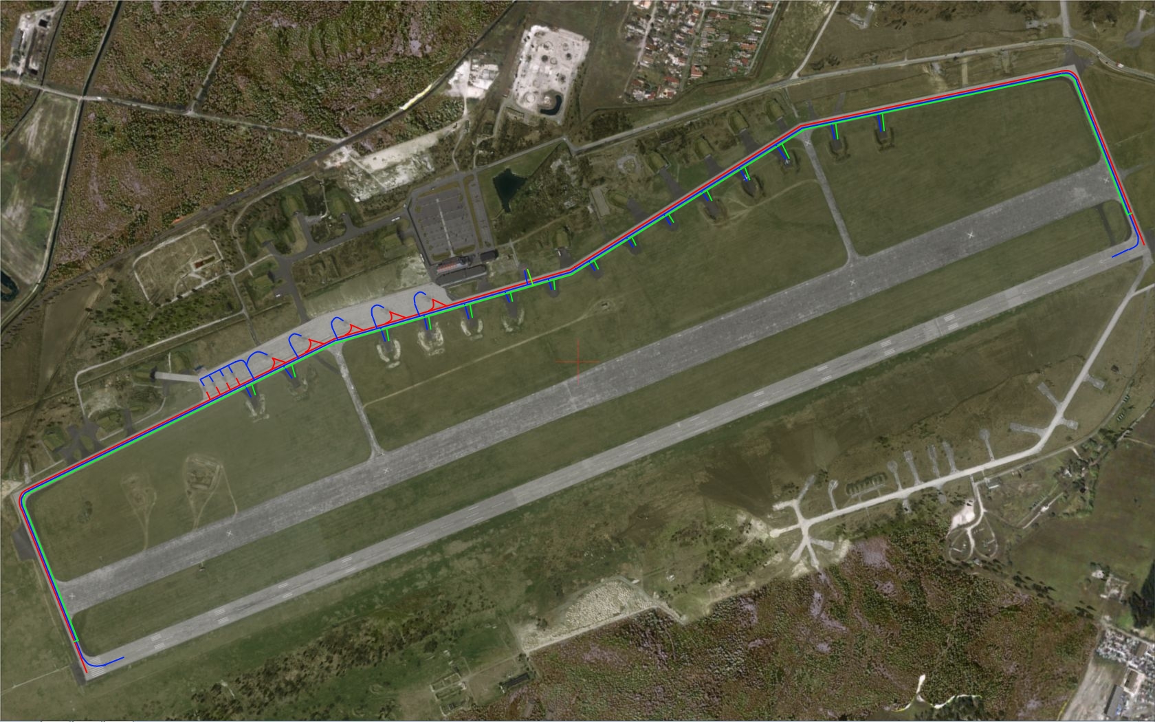
The final result of the network required to achieve ground movement appropriate for this airport is below. There are three separate networks:

  • The RED network is the departure network that services parking spots requiring DTP
  • The GREEN network is the departure network that services parking spots that do not require DTP
  • The BLUE network is the arrival network servicing all parking spots in the airport

network.jpg


Why 3 networks instead of 2?


The Major Design Hurdle


There was one serious problem with developing the pathing network for this airport - parking nodes are not end nodes. This was something that threw me for a loop, although I'm not too surprised this is how the AI works in FSX. I always imagined that when you connected a path to a parking space that path was terminated at the parking space. However it appears that FSX treats a parking space as any other node in the network. This means when the system was originally designed with two pipes (arrival and departure) the following problem presented itself:


parking hop.jpg


In the image above, BLUE represents the departure network and RED represents the arrival network. You can see how aircraft are supposed to arrive and pull into the two top parking spots from behind, and then exit straight out the other side. The two parking spots on the bottom are regular pull-in parking.


parking hop2.jpg


In the image above, RED represents the path arriving AI from runway 05R should take to reach the parking location and BLUE represents the path the AI actually takes. What is happening? AI route from runway to parking via the shortest path possible. Technically, pulling into the spot from the bottom is shorter than driving past and swinging around to pull in from the top. So the AI jumps networks by pulling in towards the parking spot and leaving the arrivals network and moving on to the departure network so it can travel the shortest distance. The aircraft does not pull all the way in to the spot - the slight dip in the path line is a fair representation of how much the aircraft deviates from the main taxiway before turning back. It also does not care if there is another aircraft currently occupying that bottom parking spot. Additionally, swapping the node positions would have no effect, the aircraft would simply spin about when jumping networks.


The worse part about all this is that all the non DTP spaces, with exception to Gate 10, were located on the Runway 23L-side of the airport, which meant aircraft taxiing in from 05R would pass them and could use any of them to hop networks.


Working Towards a Solution


My first thought was to simply remove access of non-DTP spots from one of the networks. Well, if I only left them attached to the departures network, AI could still spawn and depart but with only gates 1-10 able to accept aircraft that limited capacity at the airport for people who like having a lot of AI running around. On the other hand, if I only left them attached to the arrivals network aircraft would be able to arrive but you'd also have aircraft that would spawn and be unable to depart.


Next I decided that really only gates 1-5 were affected by this problem, and only airliners service these gates thanks to parking code assignments. So I attempted to "capture" GA aircraft and route them separate from airliner arrivals. I did this by noting where the airliners received their gate assignments while on the runway, and placing a node to the arrivals network before this, so only smaller GA aircraft would pick it up as the airliners would be past this after they landed. I then created a new arrivals network for the airliners towards the end of the runway and routed them straight to gates 1-5. It made the airport piping look like this:


network2.jpg


In the image above, which shows arrival piping only, the BLUE represents both airliner and GA arrivals and the RED represents airliner-only arrivals. Note though that GA aircraft landing on Runway 05R will stop shorter and intercept the BLUE path whereas airliners will land past the node at the start of the BLUE path and instead take the RED path. Landing on Runway 23L this whole path jumping issue is non-existent due to the taxi-in distance for the proper path to the gates being the shortest. Also notice that I'm not piping the airliners all the way up to the parking location, I'm simply denying them access to the non-DTP spots at the bottom of the ramp and hooking them back into the main arrival network as soon as possible to avoid laying down too many extra nodes. While this technique did work at consistently capturing GA aircraft versus airliners as intended, it had one insurmountable flaw.


Once I confirmed this was working I went to test Runway 23L landings and was dismayed to find that every single aircraft, GA and airliner alike, would now turn about after landing and back-taxi to leave the runway! It was a bit astounding to me as these were aircraft that would be heading to gates on the main ramp and as such a back-taxi and taxi in along the longer Taxiway B to get to the main ramp area does not seem shorter to me. However sometimes FSX AI is simply unfathomable. What was apparent however is that there was nothing I could to to stop aircraft from back taxiing without simply reverting to my previous runway pathing. Due to the fact that AI are arriving and departing on separate taxi networks, even if another aircraft was holding short for Runway 23L at the time a plane was landing and taxiing off they would simply pass right through each other. AI only yield to other AI traveling on the same path network.


I did attempt a last-ditch effort by playing around with putting breaks in the runway link, but once I realized an aircraft doesn't need a runway link to land, it will simply choose the closest apron/taxi link and follow it, I gave up.


Finally I decided that if I can't put in a separate taxi in network I would put in a separate taxi out network, which brings us back to the image at the top of this entry:


network.jpg


You'll notice that the GREEN network joins up with the RED network near the runway. This is where the hold short node is located, and this node is located closer to the runway than the hold short node for the arrival network. This means I can combine the two departure networks and not have to worry about aircraft jumping because they are already past the point of doing so when they get their final taxi in route. With this three-route network AI aircraft can arrive and depart from every available parking location and do so in a proper manner depending on the DTP nature of that spot.


Nothing Is Ever Perfect


There still remains a minor drawback to this system, and really to any taxi system that employs more than one route. The issue I mentioned earlier with aircraft taxiing through one another still exists - there's a chance that an arriving aircraft can taxi through a departing aircraft because they only react to other craft on their network (they could even taxi through the user aircraft depending on which network the AI decides you're on given your position). This can happen either when and arriving aircraft taxis past a departing aircraft pulling out onto the taxiway, or it could happen when an aircraft taxiing faster on a path with less nodes overtakes an aircraft taxiing slower on a path with more nodes (explanation: AI aircraft taxi speed is determined by the distance between nodes. The more nodes closer together on a path than spaced far apart, the slower an aircraft will taxi).


however here is where LHDC's single runway and taxiway actually mitigates this problem significantly. There are no intersections or runway crossing where separate path networks can cross over each other and lead to aircraft passing through one another. Everyone is always heading in the same direction. Add to that parking located across the length of the airport instead of one dense area and not a lot of traffic arriving/departing even on the highest traffic levels, and the chances of witnessing a "non-collision" are extremely slim.


Testing Procedures


The DTP implementation for LHDC works - on my system. This has been proven through rigorous testing with help from Super Traffic Board. Coupled with UT2, it is a powerful tool. In addition to real time data like location and status (such as noting when gate assignment is given upon landing, as mentioned earlier) I can call down any aircraft I want that's scheduled to arrive to land at any time at any runway. A B737 will hit the runway just under 2 minutes at 4x speed after I create it 20nm downrange on approach. A much slower Piper Cub will make it down in just over 6 minutes. I can also land mutiple copies. So within 10 minutes I can fill up 5 gates to test the AI's arrival to each one. Similarily, I can dispatch aircraft on command. So I can load up the airport with only a few parking spots available (due to sizing the rest too small to accept aircraft) and immediately send off all aircraft parked to test their departure from each spot. So every parking spot on the airport has been tested to make sure AI craft arrive and depart properly from both runways.


It also helps to have both FSX and UT2 traffic sliders at full to give me lots of activity to stress-test operations at the airport. Leaving the sim running at 4x speed while using my screen capture time-lapse technique to monitor it, I can come back hours later (like after sleeping) after many more hours have passed in the sim and spend a fraction of the time making sure there were no anomalies during normal operations.


I also tested with all the WoAI packages that are available for this airport.


The Final Result


I'll be sending this off to the LHSim people for additional testing - LHDC is compatible with AES and I am unfamiliar with how that application operates - it may not like what I've done to the AI network at all. I also may have missed something unique to my FSX environment that will cause the pathing network to fail on other systems. But hopefully this is an improvement that LHSim can include in the next version release, and regardless I certainly learned a lot in how to successfully plumb out an airport for DTP.

Gaiiden

KBLM to KWWD

It was cloudy, dreary and rainy outside today, but the best thing about a flight simulator is that you can choose to ignore the real weather if you want to. Certainly you can set FSX to pull down and then update current meteorological conditions, but then who wants to fly in rainy weather when they don’t have to? So after setting up a trusty Cessna 172 trainer (in yellow!) with my tail number N727DS, I changed the weather to fair conditions – no wind, partly cloudy skies, >20mi visibility. Well, where’s the fun in that?? But this trip I’m not out to battle against the forces of nature, but to take a nice leisurely VFR cruise down the Jersey Shore.

<center><object width="500" height="375"> <param name="flashvars" value="offsite=true&lang=en-us&page_show_url=%2Fphotos%2Fgaiiden%2Fsets%2F72157624784672784%2Fshow%2F&page_show_back_url=%2Fphotos%2Fgaiiden%2Fsets%2F72157624784672784%2F&set_id=72157624784672784&jump_to="></param> <param name="movie" value="http://www.flickr.com/apps/slideshow/show.swf?v=109615"></param> <param name="allowFullScreen" value="true"></param><embed type="application/x-shockwave-flash" src="http://www.flickr.com/apps/slideshow/show.swf?v=109615" allowFullScreen="true" flashvars="offsite=true&lang=en-us&page_show_url=%2Fphotos%2Fgaiiden%2Fsets%2F72157624784672784%2Fshow%2F&page_show_back_url=%2Fphotos%2Fgaiiden%2Fsets%2F72157624784672784%2F&set_id=72157624784672784&jump_to=" width="500" height="375"></embed></object></center>

So I filed the flight plan in FSX, allowing it to chart me out VOR waypoints that would vector me from Monmouth Executive airport (KBLM) down to Cape May County Airport (KWWD). But I don’t have my instrument rating yet and even if I do have rudimentary knowledge of VOR navigation from previous FSX flight lessons and experience, this isn’t an instrument flight. But it at least let me get an idea of how long the trip would take and how much fuel I would burn. I effectively doubled both figures since I knew I was taking a roundabout course down the shoreline.

After going through the pre-flight checklist and doing an exterior check of control surfaces I turned over the engine and taxiied off the apron, radioing to local traffic my intent to take off from Runway 14 departing to the South. Airspace was clear in the area, so I was able to taxi straight on to the runway and take off immediately. After climbing to my cruise altitude of 2,500ft, I contacted McGuire to get on their radar and find out if there was any traffic in my area. I freaked the controller out because I hadn’t finished trimming for cruise and ended up ascending to 2,800ft without realizing it, and a Mooney Bravo buzzed by me relatively close, so she was screaming at me to eyeball the traffic that was right on top of me. That’s what I get for spending too much time looking out the windows.

The rest of the flight was uneventful. I stuck to the coast and flew over Atlantic City, Ocean City and Wildwood before finally circling around the very tip of New Jersey at Cape May. The sun was just kissing the horizon and I had to make it to ground before it got too dark and I broke VFR rules. Tuning into Cape May traffic, I announce position and intent to land on Runway 1. Getting no response and checking around to make sure there was no traffic, I took her straight in, picking up the PAPI glidepath and touching down just left of the centerline. Taxiing off and announcing clear of runway, I pulled onto the nearest apron and parked, shutting down.

Great cruise, and gave me a chance to check out some more of the MegaEarth scenery I bought for the NJ region. Excellent VFR quality (as you will see in the gallery), I look forward to continuing my tour – I think my next hop will be across the Delaware Bay to the Middletown area over there.

Gaiiden

Wilco's Harrier Jump Jet

This review anndendum addresses various issues with Wilco's Harrier Jump Jet product. You can read more about the Jump Jet in my AVSIM review.


Aircraft.cfg


There are several useful and important edits to make to the aircraft.cfg file. Since this is a commercial product I can't provide my modified aircraft.cfg file in full but I can point out the sections that need to be modified or changed. Make sure you back up your original aircraft.cfg file before following the steps outlined below.


Missing Reference Sheet


[fltsim.4] is missing its reference sheet property, which means if you use the kneeboard you won't get a reference sheet while using this aircraft. Find this entry and add the line kb_reference=Harrier_ref


Aircraft Descriptions


If you want to be reminded what livery means what and what aircraft model is which when viewing the Details window, add a description property and the following lines for the specified [fltsim.x] (make sure to include the quotes!):


[fltsim.0]: "1 Squadron RAF\n\nThe Hawker Siddeley Harrier GR.1/GR.3 was the first generation of the Harrier series, the first operational close-support and reconnaissance attack aircraft with vertical/short takeoff and landing (V/STOL) capabilities. These were developed directly from the Hawker P.1127 prototype and the Kestrel evaluation aircraft.\n\nNumber 1 Squadron RAF was the first military unit in the World to operate the Harrier, in 1970. Deployed in the carrier HMS Hermes, the Squadron’s Harriers flew ground attack missions in the Falklands conflict of 1982."


[fltsim.1]: "3 Squadron RAF\n\nThe Hawker Siddeley Harrier GR.1/GR.3 was the first generation of the Harrier series, the first operational close-support and reconnaissance attack aircraft with vertical/short takeoff and landing (V/STOL) capabilities. These were developed directly from the Hawker P.1127 prototype and the Kestrel evaluation aircraft.\n\n3 Squadron RAF was based, with its complement of Harrier GR.3s, in Germany at RAF Gutersloh."


[fltsim.2]: "233OCU (Operational Conversion Unit)\n\nThe Hawker Siddeley Harrier GR.1/GR.3 was the first generation of the Harrier series, the first operational close-support and reconnaissance attack aircraft with vertical/short takeoff and landing (V/STOL) capabilities. These were developed directly from the Hawker P.1127 prototype and the Kestrel evaluation aircraft.\n\nThis unit trained pilots for Harrier operations. They also trained Royal Navy and Fleet Air Arm pilots, as well as those from overseas such as the Indian Navy and USAAF."


[fltsim.3]: "FAA 899 Squadron\n\nThe British Aerospace Sea Harrier is a naval V/STOL jet fighter, reconnaissance and attack aircraft, a development of the Hawker Siddeley Harrier. The first version entered service with the Royal Navy's Fleet Air Arm in April 1980 as the Sea Harrier FRS.1, and was informally known as the Shar\n\n899 Squadron flew alongside the RAF’s Harriers in the Falklands conflict. '711' is finished in the low visibility paint used at this time, in the early 1980s."


[fltsim.4]: "FAA 801 Squadron\n\nThe British Aerospace Sea Harrier is a naval V/STOL jet fighter, reconnaissance and attack aircraft, a development of the Hawker Siddeley Harrier. The first version entered service with the Royal Navy's Fleet Air Arm in April 1980 as the Sea Harrier FRS.1, and was informally known as the Shar\n\nThe RAF’s Fleet Air Arm flew navalised versions of the GR3 called FRS1 or more commonly, 'SHAR' (short for Sea Harrier). 801 Squadron Sea Harriers were deployed in HMS Invincible during the Falklands War. This machine is finished in the overall dark sea grey scheme. Here the bleed air doors are clearly visible in the intake mouth."


[fltsim.5]: "The British Aerospace Sea Harrier is a naval V/STOL jet fighter, reconnaissance and attack aircraft, a development of the Hawker Siddeley Harrier. The first version entered service with the Royal Navy's Fleet Air Arm in April 1980 as the Sea Harrier FRS.1, and was informally known as the Shar"


[fltsim.6]: "1 Squadron RAF\n\nThe Hawker Siddeley Harrier GR.1/GR.3 was the first generation of the Harrier series, the first operational close-support and reconnaissance attack aircraft with vertical/short takeoff and landing (V/STOL) capabilities. These were developed directly from the Hawker P.1127 prototype and the Kestrel evaluation aircraft.\n\nNumber 1 Squadron RAF was the first military unit in the World to operate the Harrier, in 1970. Deployed in the carrier HMS Hermes, the Squadron’s Harriers flew ground attack missions in the Falklands conflict of 1982. Devoid of all markings and looking decidedly “war-weary” this depiction illustrates the ruggedness of the Harrier, an aircraft more than fit for the purpose for which it was built."


Aircraft Performance Figures


Another thing missing from the Details window are the full performance specs for the Harrier. These are actually included in the default aircraft.cfg file but are improperly placed in the description field of one of the [fltsim.x] entries. You'll have already deleted them and replaced them with the proper value from above so copy and past the text below (no quotes needed) into the performance property of the [General] section:


Length: 47' 7'\nWing span:33' 8'\nMax TOGW: 31,000 lbs\nPower: Rolls-Royce Pegasus F402-RR-408 \nMax Speed: 634 kts (SeaLevel)\nMax TakeOff weight (VTO, 80degrees nozzles): 21000 lbs\nMax Takeoff weight (STO, 60 degrees nozzles: 25000 lbs)


Incorrect Flight Number


The flight number for [fltsim.0] does not match the tail number of the aircraft like the rest. The atc_flight_number property should read XW921.


Edit Voicepack Additions


If you know how to use Edit Voicepack then you can download my Harrier Jump Jet Voicepack file from the AVSIM library and make the following adjustments:

  • Change the [fltsim.3] atc_airline property to Adder. This is a telephony designation that comes with the included comunity mods in the default Edit Voicepack install and the description reads it's for the 899 squadron.
  • For [fltsim.0], [fltsim.1], [fltsim.2] and [fltsim.6] entries add atc_model=HAR
  • For [fltsim.3], [fltsim.4] and [fltsim.5] entries add atc_model=SHAR
  • Remove the atc_model=HAR property from the [General] section
  • Change the atc_type property in the [General] section from BAE to HAWKER SIDDELEY

Once the voicepack mods are installed and the above changes made you'll be called by your call sign in addition to your flight number by ATC, and when identifying yourself to ATC you'll properly say your manufacture type as well as which model of Harrier you are currently operating.


Shockwave 3D Lights


If you use Shockwave lights then here are the settings to replace what is in your [lights] section:


light.0 = 3, -7.8, -12.2, -0.25, fx_shockwave_navred

light.1 = 3, -7.8, 11.9, -0.2, fx_shockwave_navgre

light.2 = 3, -22.75, 0, -0.5, fx_shockwave_navwhi

light.3 = 2, -7.75, -12, -0.4, fx_shockwave_strobe_sm

light.4 = 2, -7.75, 12, -0.4, fx_shockwave_strobe_sm

light.5 = 2, -11.2, 0, -1.4, fx_shockwave_strobe_lowl

light.6 = 1, -7.89, 0, 3.5, fx_shockwave_beaconh_lowl

light.7 = 1, -11.4, 0, -1.35, fx_shockwave_beaconb_lowl

light.8 = 6, 11.5, 0, 2.76, fx_shockwave_vclight

light.9 = 5, 6.5, -.1, -3.4, fx_shockwave_landing_light

light.10 = 8, -4, 4, -5, fx_RCB_Smoke90, //Smoke Downwards

light.11 = 8, -4, -4, -5, fx_RCB_Smoke90, //Smoke Downwards

light.12 = 10, -4, 4, -5, fx_RCB_Smoke45, //Smoke 45 degrees

light.13 = 10, -4, -4, -5, fx_RCB_Smoke45, //Smoke 45 degrees

light.14 = 9, -15, 4, 0, fx_RCB_Smoke0, //Smoke Backwards

light.15 = 9, -15, -4, 0, fx_RCB_Smoke0, //Smoke Backwards


light.16 = 7, 3, -2, -2.3, fx_RCB_Cannon3,

light.17 = 7, 3, 2, -2.3, fx_RCB_Cannon3,


Take note that light.8 was added by me and ties into the taxi lights to turn on cockpit lighting since I could not get the cockpit light to work. Make sure you have the latest update for the Shockwave lights.


Also I've added light.9 which places a landing light beam from the nose gear as I could also not get the landing light to work. If you choose to keep this addition then you should also go into the Harrier's panel.cfg (after making a backup) and add the following line to end of the [Vcockpit01] section:


gauge07=shockwave_lights!SW Lights_gear , 1,1,1,1 //shockwave light


This will make the landing light automatically switch off when you raise the gear. You will need to turn it back on when the gear is lowered however.


Sound.cfg


Ground Noise Tweak


The aircraft will emit a constant ground roll noise even when resting still on the tarmac in a shut down state. To remove this low background rumble (sounds like wind) simply open up sound.cfg (after making a backup of the original first) and change the minimum_volume property of the [GROUND_ROLL] entry from 8000 to 4000. You won't hear the ground roll noise anymore when not in motion but it will come back properly as you taxi.


Canopy Open/Close Sound


There's no sound when you open and close the canopy. To add sound open the sound.cfg file for the default F/A-18 (assuming you have the Acceleration Pack installed) and copy the [EXIT_OPEN] and [EXIT_CLOSE] entries from there and paste them at the end of the Harrier's sound.cfg file.


Next you either have to edit the filename property with the full path to the WAV files in the F/A-18 sound folder or simply move them into the main FSX sound folder, where the sim will search for them when it can't find them in the Harrier sound folder.


Checklists


I have created a full set of procedures to follow from a cold and dark start up to a complete systems shut down. They can be downloaded in kneeboard form from the AVSIM file library.

Gaiiden

What is to come

Let's go over what I'll be talking about here on this blog.


Brief intro: I'm a flight sim enthusiast who has dabbled in sims from Flight Simulator II back in the 80's to Jane's in the 90's and Microsoft Flight Simulator moving into the 21st century. Civilian sims, combat sims, I've played the whole lot of them - although some more than others and others hardly more than once. After a few years hiatus to focus on getting into the game development industry (The Sims also played a significant role in sucking up any idle time I had) I got back into Flight Simulator around 2009 and now I write reviews for AVSIM and design freeware scenery (see the info box to the left for more on that).


There are four main topics I'll be discussing:


Random Ramblings


To be categorized as "uncategorized", these posts will cover some aspect of flight simulation and will sometimes be an opinion piece about something that's buzzing in the flight simulator community not just here on AVSIM but around the web. I'm not a very opinionated person nor am I usually one to bother sharing opinions whenever I find I have one, so don't expect these type of postings often. Generally I'll stick to commentary - I'm not looking to start a lot of arguments around here.


Review Addendums


If you've read my reviews (see info box on the left) you'll know that I tend to do a lot of tweaking to the product over the course of my review to make it even more realistic or effective. In my Texan review I made changes to the aircraft config file, created a voice pack mod for the aircraft model, and a few more things. For my Aerolites Falcon review, although I did not include them, I extensively revised the checklists for the aircraft and its various variations. For my first scenery review I did a lot of editing the airport file to fix parking issues, taxi accuracy, and more. I'll now be including these extra things here after the review has been posted.


Flight Logs


I still hop in the cockpit every now and then to go for a fly, and I record what occurs on these flights for two reasons: One is that I try to use as many real-world procedures and rules as possible wherever and whenever I fly, so for my own future reference I like to make notes of how I handled, for example, a DME arc so I can look back later on when I want to fly a DME arc again and make sure I don't repeat any mistakes. The second reason is that in describing the methods and procedures I'm using and the mistakes I'm making when doing so I hope others can also learn. Each flight log has a picture gallery as well. I have several already published I'll be adding here once a week until I'm all caught up, interspersing them with more recent flights as I undertake them.


Scenery Design


Every now and then I may have some thoughts or tutorials to share on scenery design as I continue to gain experience - I've only been doing it for just over a year now and am still learning as I go on. I don't model or texture yet (maybe won't at all - I was never good at that I found when I was doing game development) so I'll mainly be focusing in airport design and functionality.


And that's all! I hope everyone enjoys reading :)

Gaiiden

Aerosoft's Rotterdam X

Click here to read my review of Rotterdam X.


There are a number of issues with Rotterdam X that can be solved through the use of your AI traffic program and the freely-available Airport Design Editor (ADE). The commercial product Airport Studio (AS) is recommended also as you can edit the airport while the simulator is running and see where you are putting things in relation to the airport ground textures. Fixing these issues has lent a much more realistic feel to the airport as the scenery looks amazing but does not function all that well when you actually use it. Let me just say right up front that modifying commercial scenery is okay so long as you do not distribute any of the files you edit, which is why I'm simply describing here the things I did for other people to consider implementing themselves. Perhaps Aerosoft would be willing to work some of these into a future update to the scenery.


Issue #1: Unclassified parking


<a href="http://www.blade-edge.com/images/avsim/rotterdamX/addendumParkingCodes.jpg"><img'>http://www.blade-edge.com/images/avsim/rotterdamX/addendumParkingCodes.jpg"><img src="http://www.blade-edge.com/images/avsim/rotterdamX/addendumParkingCodes.jpg" align="right" width="202" hspace="5px"></a>None of the parking spots in the airport are coded to accept certain aircraft, which will lead to GA craft parking in airliner gate spots. This isn't completely the fault of the scenery designers as assigning airline codes could cause issues for customers who are using AI traffic that doesn't use the codes they used, and also because there's no rule saying some commercial GA traffic can't be routed to a gate parking spot. But for the purpose of my scenery usage I want airlines parking at gates and all GA aircraft using ramps.


If you are only using FSX default traffic, then you can use ADE or AS' parking properties airline code drop down list to select the airline codes to assign to a parking location. If you use a 3rd-party traffic program like Ultimate Traffic 2 make sure you use the airline codes from that program as they can be different. If you are using extra traffic from packages like World of AI, they also may use codes different than what FSX has listed by default and your traffic program uses. To find out what code any aircraft is using, open up its aircraft.cfg file and look for the section(s) [fltsim.x] where x is a number. In these sections you will find the property atc_parking_codes. These codes are what you should put in the parking spot code list in ADE or AS.


Issue #2: Lack of GA parking


The default scenery does not include a lot of parking options for General Aviation aircraft and if you run your sim with a lot of AI traffic you can reach capacity easily as this is a high-volume GA airport. This means arriving aircraft will disappear from the runway when they can't locate an open parking space. The default airport has 13 ramp parking locations and now that I've made it so GA traffic can't use a gate spot this makes the parking situation even worse. To increase capacity I added 40 more parking locations. The tie down area west of the main tarmac can hold as many as 17 20' (radius) parking locations. I also added 2 20' and 2 33' parking to the end of Taxiway A. 4 33' and 4 46' parking spaces were placed over in the Jet Center parking area and 12 20' along with 12 33' parking spaces were squeezed into the rear tie down area at the end of Taxiway F.


I also made added a "JET" code to the parking spaces in the Jet Center, then went into my AI traffic aircraft.cfg files and added the code to the atc_parking_codes line in all the business jet aircraft so that only jets park in the Jet Center. Makes sense right? :P


<center><a href="http://www.blade-edge.com/images/avsim/rotterdamX/addendumXtraParking.jpg"><img'>http://www.blade-edge.com/images/avsim/rotterdamX/addendumXtraParking.jpg"><img src="http://www.blade-edge.com/images/avsim/rotterdamX/addendumXtraParking.jpg" width="250" hspace="2px"></a><a href="http://www.blade-edge.com/images/avsim/rotterdamX/addendumXtraParking2.jpg"><img'>http://www.blade-edge.com/images/avsim/rotterdamX/addendumXtraParking2.jpg"><img src="http://www.blade-edge.com/images/avsim/rotterdamX/addendumXtraParking2.jpg" width="250" hspace="2px"></a>

Parking layout for West Tiedown and Taxiway A (left)

and Jet Center and Taxiway F (right)</center>


Issue #3: Lack of names for GA parking


<a href="http://www.blade-edge.com/images/avsim/rotterdamX/addendumATCParking.jpg"><img'>http://www.blade-edge.com/images/avsim/rotterdamX/addendumATCParking.jpg"><img src="http://www.blade-edge.com/images/avsim/rotterdamX/addendumATCParking.jpg" align="right" width="250" hspace="5px"></a>None of the GA parking spots have names, which gives you limited options when you taxi off the runway and ask for a parking location - ATC will simply assign you an open spot somewhere in the airport that matches your aircraft's specifications. I went and named all 4 GA parking locations based on their position to the airport's center. So you end up with a West (Taxiway L), Southeast (Taxiway J) and South (Taxiway F) parking as well as Gate A (Taxiway A). Now when you pull past the hold short on arrival you can request to be sent to a specific parking area of the airport. If you still don't care you can do a generic parking request. Asking to be sent to a gate will always put you at Gate A if you are a GA aircraft small enough to park there. Another benefit is that when you go to start a flight at Rotterdam you can see from the list of parking options in the FSX Location window where in the airport the parking is located.


Issue #4: Runway extends onto threshold


AI aircraft only use runway properties to determine landing distance in addition to their own configuration settings - they do not follow PAPI or ILS glideslopes. Since Rotterdam X's default runway extends onto the threshold but does not have any threshold value of its own set in the runway properties, AI aircraft will see the beginning of the threshold as the beginning of the runway, which isn't correct as you are not supposed to land on runway thresholds. Larger aircraft will still overshoot the threshold on approach, but smaller aircraft like the Piper Cub will indeed land short of the actual runway markings. In some cases this will create a longer roll-out period for some of the larger aircraft to find their exit taxiway. To get aircraft landing as they should you need to shorten the runway length to 5,907 feet. The runway will shrink from both ends so you don't need to reposition it and this new length will expose the threshold and place the runway only under the runway markings.


Issue #5: AI aircraft taxi off the taxi lines


This is a relatively simple fix, although if you don't have Airport Studio you'll need to import an image of the ground textures into ADE so you can drag the taxi links over the taxi lines drawn onto the ground textures. Basically it's just a process of making the two lines lay on top of each other. There is a downside to making the aircraft follow the lines in that to do so you need to lay significantly more nodes to get the aircraft turning properly along the taxi line curves. AI aircraft taxi speed is determined by the distance between two nodes - longer the distance the faster the speed. Since you are adding more nodes and closer together you are effectively making aircraft take several seconds longer to taxi around the airport. The impact isn't huge, but it is noticeable if you happen to get stuck behind one of them. But if you can't bear to watch your AI aircraft taxi with apparent blatant disregard to taxi lines, this slightly reduced taxi speed is just something you'll have to deal with.


<center><a href="http://www.blade-edge.com/images/avsim/rotterdamX/addendumTaxi.jpg"><img'>http://www.blade-edge.com/images/avsim/rotterdamX/addendumTaxi.jpg"><img src="http://www.blade-edge.com/images/avsim/rotterdamX/addendumTaxi.jpg" width="250"></a>

Airport Studio with transparency enabled to see under the aprons and

taxiways so you can align to the taxi lines. Some links have been deleted

to expose the taxi line for this image</center>


Issue #6: AI aircraft don't hold short properly


<a href="http://www.blade-edge.com/images/avsim/rotterdamX/addendumHoldShortAS.jpg"><img'>http://www.blade-edge.com/images/avsim/rotterdamX/addendumHoldShortAS.jpg"><img src="http://www.blade-edge.com/images/avsim/rotterdamX/addendumHoldShortAS.jpg" align="right" width="250" hspace="5px"></a>AI aircraft look for a special hold short node when taxiing to tell them when to stop and ask for takeoff clearance on departure and stop and ask for parking on arrival. This node can be placed anywhere, although generally it's in close proximity to the runway so that ATC does in fact grant departing aircraft takeoff clearance - arriving aircraft don't care if the node isn't close to the runway. In the default Rotterdam X airport file the hold short nodes are too close to the runway, causing aircraft to taxi over the hold short lines drawn on the ground textures. To fix this we simply move these nodes back to just after the hold short markings (see image from Airport Studio on the right). This will have aircraft stopping just short of the yellow line and ensure that aircraft arriving taxi fully over the hold short marking before requesting parking. Some of the taxiway hold shorts are very far away from the runway, but those taxiways are only used for arriving aircraft and we don't care if the hold short is far from the runway.


<center><a href="http://www.blade-edge.com/images/avsim/rotterdamX/addendumHoldShort.jpg"><img'>http://www.blade-edge.com/images/avsim/rotterdamX/addendumHoldShort.jpg"><img src="http://www.blade-edge.com/images/avsim/rotterdamX/addendumHoldShort.jpg" width="250"></a>

ADE says our hold short nodes aren't close enough to the runway to work,

but the top one does. If you modified the runway to not use the threshold,

then that will indeed be too far away for the hold short on the bottom

to work, otherwise it will too</center>


Issue #7: AI aircraft don't follow proper ground movements


I've saved the most complex issue for last. Rotterdam is laid out so that it can use two parallel taxiways to bring aircraft in and send them out at the same time without any serious interruptions in traffic flow regardless of which runway end is in use. Recreating this in FSX is, I have found, not entirely possible thanks to limitations with the AI in the simulator. I may be wrong, but hours of research and testing have yet to show me otherwise. You can come very close though - I'd say my current implementation is about 95% effective and only every now and then do you see a plane behaving improperly. It has created issues with ATC giving the user proper taxi-in directions however. Where it may tell an AI craft to taxi in via the proper "arrival" taxiway, it could send a user aircraft down a "departure" taxiway depending on where they stop after the hold short line and call in for parking. While I never witnessed an AI aircraft vanish off the taxiway after arriving due to not receiving complete taxi-in directions, I have had ATC merely say to me "taxi to general aviation parking ." and leave out any taxiway directions.


So because it's not possible to guarantee proper AI movement or proper user communications with ATC, it's obvious why this wasn't included in the commercial product release. But if you don't mind a few glitches here and there in the fight for a more realistic FSX environment then it can be worth the effort to get this system up and running. In my review I showed Runway 06 ground movements. Here is a video showing proper ground movement for Runway 24.


<a href="http://www.blade-edge.com/images/avsim/rotterdamX/addendumR24.jpg"><img'>http://www.blade-edge.com/images/avsim/rotterdamX/addendumR24.jpg"><img src="http://www.blade-edge.com/images/avsim/rotterdamX/addendumR24.jpg" align="right" width="250" hspace="5px"></a>If you're interested in trying to get this ground movement system working, the most important thing you need to understand is how to control AI aircraft's departure from the runway. Taxi for departure is a trivial matter to set up and get functioning, arrival is the tricky part. Airplanes of different classes will land in different spots on the runway (smaller the aircraft, closer the landing to the runway threshold) and also slow to taxi speed over different distances (smaller the aircraft, shorter the roll out). Once an AI aircraft has slowed to taxi speed it will immediately look to exit the runway to a parking location via the shortest route possible. In some cases, this exit point may be behind them. Back-taxiing to a taxiway isn't an unheard of technique for smaller planes in the real world, but you have to account for this possibility and try to prevent this from happening in some instances. For example, when Runway 24 is active, you can't let small aircraft use Taxiway V2 to exit the runway, or else they will taxi back along Taxiway V and either cause an arriving and departing aircraft to end up head-to-head and stop taxiing and time out or the two aircraft will simply taxi through each other. The image on the right shows how you can "intercept" aircraft before a runway exit and lead them down the runway to a further exit (as long as that exit happens to be in the direction of parking - remember, shortest route is the main determining factor). Red is for R24 arrivals and green is for R06 arrivals.


<a href="http://www.blade-edge.com/images/avsim/rotterdamX/addendumDoubePipe.jpg"><img'>http://www.blade-edge.com/images/avsim/rotterdamX/addendumDoubePipe.jpg"><img src="http://www.blade-edge.com/images/avsim/rotterdamX/addendumDoubePipe.jpg" align="left" width="250" hspace="5px"></a>What if you have no choice but to deal with aircraft exiting off the same taxiway for both arrivals? In this case you will have to look into a double-plumbing system that will guide the arrivals down the proper taxiway depending on where they exit the runway onto the taxiway. In the image on the left, red is once again for R24 arrivals (you see it extend off the image to the right, where it connects to the runway in the previous image) and green is for R06 arrivals. Once on the taxiway these lines overlap - they are exposed side-by-side here to make it easier to see them. Blue lines represent the base taxiway network where no double-piping needs to exist as these taxi lines do not connect in any way that would lead an AI aircraft astray. For R06 arrivals, the first exit point is meant to capture the smaller aircraft like Piper Cubs before they try and back-taxi and the second is for small aircraft that need to back-taxi. The red exit you see is for aircraft that don't need to be pulled away from the Taxiway V2 exit as their roll outs take them far enough down the runway when arriving on R24.


I won't lie - getting this working was not easy. It was educational, I'll tell you that, but it took hours of testing and I must have come close to giving up at least 5 times. And again, it's not perfect. But it's close enough for me and maybe for anyone else out there willing to give it a go. For further reading on AI behavior I would recommend this wiki article from FSDeveloper. You might also consider tweaking aircraft dynamics to effect things like roll out distances to further control where airplanes exit the runway, however be warned that you would be tuning aircraft for one airport in particular - which may cause unforeseen effects when dealing with the plumbing system of other airports.


Good luck!

Gaiiden

KWWD to KPHL

Another great flight this morning. The actual weather was, once again, not very preferable so although I used the real-world time for my flight, I simply set the weather to Fair just like last time so that I could enjoy the focus of this flight, which was the VFR scenery. Someday I’ll want to battle my way from one airport to another through a raging snowstorm or torrential thunder shower, but for now I would like to cruise easy and enjoy the scenery. All you hyper realism junkies take a hike.

<center><object width="500" height="375" classid="clsid:d27cdb6e-ae6d-11cf-96b8-444553540000" codebase="http://download.macromedia.com/pub/shockwave/cabs/flash/swflash.cab#version=6,0,40,0"><param name="flashvars" value="offsite=true&lang=en-us&page_show_url=%2Fphotos%2Fgaiiden%2Fsets%2F72157624784839558%2Fshow%2F&page_show_back_url=%2Fphotos%2Fgaiiden%2Fsets%2F72157624784839558%2F&set_id=72157624784839558&jump_to=" /><param name="allowFullScreen" value="true" /><param name="src" value="http://www.flickr.com/apps/slideshow/show.swf?v=104087" /><param name="allowfullscreen" value="true" /><embed width="500" height="375" type="application/x-shockwave-flash" src="http://www.flickr.com/apps/slideshow/show.swf?v=104087" flashvars="offsite=true&lang=en-us&page_show_url=%2Fphotos%2Fgaiiden%2Fsets%2F72157624784839558%2Fshow%2F&page_show_back_url=%2Fphotos%2Fgaiiden%2Fsets%2F72157624784839558%2F&set_id=72157624784839558&jump_to=" allowFullScreen="true" allowfullscreen="true" /></object></center>

So you may notice that I started this flight off at the airport I landed at in my last flight. I'm going to continue to do this. Despite having the power to pop up at any airport in the world and take off from there, I've decided to make things more interesting - if I want to go someplace, I have to get there by actually flying there. This serves two purposes. First, it means that I can't go very far right now, since I don't have much radio navigation experience and I'm stuck in a rather slow aircraft. But this is good, because I still have lots of scenery to explore right here in the tri-state area. Second, it helps motivate me to learn more in order to reach places I can't get to at this time. I'll need to get my Instrument Rating so I can handle longer flights in varying conditions, I'll have to get comfortable flying faster planes so I can travel farther quicker, and I'll have to gain more flying hours overall to achieve this.

So, for today's flight I checked out the Southeastern-most limits of my current VFR scenery library in this region, which is the bottom of New Jersey and Northeastern segment of Delaware. Since I'm from Middletown, I decided it would be cool to fly over Middletown, DE. To get there, since I don't know the land anywhere well enough to fly there by sight, I had to set myself up to bounce from VOR to VOR. The flight plan to get there called for takeoff from KWWD, intercepting the 330° radial outbound from Sea Isle VOR, tracking that to KMIV, turning due West to intercept the 330º radial outbound from the Smyrna VOR, and track that until I intercepted the 30° radial inbound to the Dupont VOR. At the intersection of these last two radials is Middletown, DE.

Once I flew over Middletown, I continued to track the Dupont VOR which brought me to KILG, where I contacted the tower and got clearance to do a touch and go on Runway 1. After the T&G I flew the pattern (thanks, Colin, for the suggestion!) and did another Runway 1 T&G before vectoring out along the Delaware River to head towards KPHL. I contacted Philly Approach to be mindful of traffic until I was closer to the airport then contacted the tower for landing instructions. They slotted me in behind a Learjet 45 and I made a direct approach to Runway 9R. Upon landing and clearing the runway, I switched over to Ground and of course received taxi instructions I couldn't even begin to remember. Thankfully FSX has a progressive taxi feature which gives me arrows to follow. On VATSIM I would have had Ground do the progressive for me, though they probably wouldn't have been happy I didn't do my homework and had an APD of the airport ready.

Couple of minor mistakes on this flight. First, I seem to not know how to read an altimeter, and I belatedly realize (looking at the screenshots) that I was cruising at 1500 feet instead of the 2500 feet I filed in my flight plan. I did ascend to proper altitude after my final departure from KILG though. Second, I set my OBS incorrectly for the Dupont VOR and barely fixed it in time. I was supposed to track in the 30º radial, so I of course set the OBS to "30" on my NAV2 gauge. Ooops. "30" is actually 300º! I should have set it to "3", which I did just as I was intercepting the radial. Third, on my traffic pattern around KILG, I executed the base turn to final too late and rolled out to the right of the runway and was too high and had to cut throttle to idle in order to descend in time. Oh and I still taxi like a drunk driver.

I will, however, pat myself on the back for making three successful visual approaches without the help of any glide slope indicators. Both runways I landed on (landed on one twice) didn't sport any fancy VASI or PAPI indicators, which was a first for me. I almost, almost came down short of the runway at KPHL and I'm pretty sure I was below the slope on all three approaches, but I didn't crash. I'll give myself another pat for successful use of Navaids on this flight to get me where I wanted to go.

Next flight will be back up into Central Jersey. I'll touch and go at Trenton and then fly back out to KBLM. I might be in a different plane as well.

Gaiiden

Ahhh my first flight of 2012! Also my first flight since the start of November, yikes. Reminded me why the FAA mandates check rides every few months for proficiency, especially considering some of the mistakes I made on this flight. Thankfully I was able to run my computer at 4.5GHz again after accidentally wiping out my overclocking settings a few weeks ago. I didn't remember I had included details as to how I set up my overclocking in a previous Flight Log entry until I looked back and so getting it setup and running again was easy. Phew! Those extra megahertz do indeed make a difference in performance!


So the objective of this flight was two-fold. One: to get in some night time flying, of which I don't have many hours logged. Two: to visit some of the airports I've designed and released over the last three months.


Here is the flight plan.


Leg 1: KFWN to N73


This was originally supposed to be two legs, from KFWN to KMMU and then on to N73. However I decided that KMMU was way to close to fly to, even for a touch and go – too much too fast for me to handle after just hopping back into the cockpit after a while on the ground. The longer flight from KFWN direct to N73 gave me more time to get back into the groove from takeoff to landing, especially considering I was flying the quicker Bonanza V35B.


The first attempt at this leg is where I made my first mistake by failing to visually inspect my aircraft for properly operating navigation lights. Granted it’s not something that’s on any of my checklists, but it is now! After departing and climbing to cruise altitude I stepped outside to capture some photos and noticed I was running without any lights – strobe, navigation and beacon were all not showing up. Realizing I couldn’t continue into growing darkness without navigation lights, I immediately considered landing at a nearby airport but I was at 5ooo feet and didn’t want to descend to anything right beneath me. I decided instead I still had enough light to turn around and head back to Sussex – bonus would be the sun would be behind me illuminating my instruments as I found my panel lighting also to be malfunctioning. So I backtracked my VOR radial and entered the pattern, cutting my downwind leg a bit short to beat in an aircraft on direct approach – I tried to clear the runway in time for him to land but he waved off just as I pulled onto the taxiway. Sorry dude, but my situation was bordering on emergency with coming darkness and I had to get to ground fast. After pulling up to the repair hangar I shut down and troubleshot the problem – turns out the new updated aircraft.cfg file released with the optional patch had the light positions all wrong for some reason. I replaced them with the light positions from the original .cfg file and all was right again.


So a bit later I was back in the cockpit and once again leaving Sussex behind and climbing for FL05. There was a crapton of traffic still in the air so I called into NY Approach for flight following and I tracked towards my VOR. As I was just hitting the VOR and getting ready to turn east I ran into a small bank of clouds at around 4700 feet, luckily there was a gap between them that allowed me to circle around and resume course without breaking VFR or changing altitude. As I approached the NJ Turnpike I switched off instruments to visual navigation, tracking the Turnpike southwest and trying not to lose it as it snaked past several other major highways. I personally find it a lot harder to identify roadways at night. After intercepting the Turnpike I also began a nice slow descent while NY Approach handed me off to McGuire Approach. I used flight following until I dropped to around 2500 feet and was closer to N73 when I switched to McGuire for a weather report. However it seems ATIS at KWRI is non-existent in FSX so I simply fell back on my weather planning I had done prior to flight and overflying the field to check the sock. My weather plan was spot on and I made my planned approach to Runway 23, coming in a bit high on final causing a little dive towards the runway but still had plenty of roll out and managed to give the Cessna behind me enough time to land afterwards. Once parked and shut down, reviewing my flight made me realize I had forgotten to do an ident on the VOR to ensure it was properly operating and that I was in fact tuned to the right station. Luckily (this time) it wasn’t an issue.


Leg 2: N73 to KBLM


The next morning it was up early and into the Tailwind W10 tri-gear, which was designed by Lionheart Creations. It’s a nifty little plane and I hadn’t really flown it more than once or twice since I got it during a sale so I figured I might as well take it out again. I got into the cockpit and went through a modified preflight – it doesn’t come with its own checklist they just ripped the Cessna 182S one from FS9 – but had trouble getting the engine to turn over. I think this is from the V35B having only left/right fuel tank selection, so when I reloaded the flight from last night and switched aircraft, the Tailwind effectively had no fuel flow since it only has a single tank (or two with one feed, dunno for sure). Eventually I just reset the flight with the aircraft already running. My first impression is that the volume for everything in this aircraft is a lot louder than the other aircraft I fly. The fuel pump, for example, is a loud as the engine itself. Also when toggling the panel lights with a keystroke it doesn’t toggle the dash switch. So if you toggle the lights on with a key then click the switch on, the panel lights will go off.


After fiddling around a bit more and getting used to the instrument layout I taxied towards the runway but after the heavier V35B I wasn’t ready for how quickly this aircraft accelerates and ended up crashing into a hangar. Whoops. Luckily damage was minor and I was able to get back to taxiing in short order, keeping a lighter hand on the throttle as I did so! Once departed from Red Lion it was a quick climb to 1500 feet cruise – this sucker is indeed fast! But once you get it leveled and trim it’s very stable and well behaved. Switching to spot view for some pictures I didn’t stay long because the outside engine noise is on a blatantly obvious loop lasting only about 3 seconds – it was pretty annoying. As I approached the coast and throttled back to slow down and drop lower for a buzz past Barnegat Light I also noticed no real discernible change in engine pitch until I had throttled down to near 50%. Oh at this point too I realized I had forgotten to continue my checklists after takeoff and upon returning to them I realized I still had flaps down from takeoff. And the VOR I used to track out to the coast? Didn’t ident. GAH!!


After following the coast north I made a direct approach for Runway 32 at KBLM after calling in and checking the weather matched the report in my plan. However on final another aircraft decided to ignore the fact that I had been announcing my approach for the last 10 minutes and taxied onto the runway for takeoff. I tried to slow down to let him go ahead of me but ended up having to call a go around. My second time around there was more traffic departing but thankfully they were kind enough to wait for me to land. However I then went and flipped the aircraft as I tried to rush and exit at the nearest taxiway. Although I will say I thought for sure I had slowed down enough to make the turn, apparently I hadn’t – no doubt my inexperience with the aircraft led to this disaster. I should probably have handled it with more care not having flown it much huh?


Leg 3: KBLM to KVAY


So technically I made it to KBLM and was totally not in the mood to try that entire leg again so I just hopped into the ol’ 172S which I had left stashed in one of the long-term hangars north of the airport. Before that though I reset the time to bring the sun up a bit more. I realized a bit later that since FSX was designed prior to the recent Daylight Savings Time changes, when I set the clock to real-world time it would put it an hour behind and not expect dawn to arrive until 8:21 instead of 7:21.


After the disaster of Leg 2 this leg was. thankfully, much nicer. I had no troubles departing KBLM and after reaching cruise I even remembered to finish off my checklists and ident the VOR I was tracking towards. Then it was just time to sit back and enjoy the sunrise and watch the traffic moving about the sky around me. Once I hit the VOR I began a gentle descent that put me near pattern altitude as I approached KVAY, which is bunched up with Flying W N14 and Red Lion N73. I threaded over both runways which set me up nicely for a pattern entry to Runway 08, although I was a bit off on the altitude I otherwise flew the pattern without issue, ending up on slope and centered as I turned final. I made sure to stay on slope to clear the power lines in front of Runway 08 and came down to a slightly bumpy landing.


Since KMMU was the only recently-developed airport I didn’t get to visit, that will be the target of my next flight, though I’m also working on a small grass field a little ways south as well that I might take a small plane to and back, and then cruise up past NYC to get to KMMU and then take a helicopter into the city? We’ll see.


Cross-posted on my personal blog

Gaiiden

KPHL to 4N1

This time out I hopped into a Mooney Bravo because I had a lot of ground to cover, and the Mooney cruises at 160 kts while the Cessna 172 cruises at only 100 kts. The flight plan called for a departure from KPHL (where I arrived yesterday), then I would follow the Delaware River Northeast until I intercepted the 115° radial inbound to the Robbinsville VOR, which would let me skirt around the restricted airspace surrounding McGuire AFB. This would put me in line with KBLM, where I would enter the pattern, do a touch and go, then depart Northeast to fly over my house and out to the tip of Sandy Hook. Turning East at Sandy Hook, I would track the 110° radial inbound to the Solberg VOR, then track out on the 30° radial which points me straight at VOR Sparta. Upon hitting Sparta, I track the 90° radial outbound until I establish visual on Runway 6 at 4N1, then take it straight in for a landing.

<center><object width="500" height="375" classid="clsid:d27cdb6e-ae6d-11cf-96b8-444553540000" codebase="http://download.macromedia.com/pub/shockwave/cabs/flash/swflash.cab#version=6,0,40,0"><param name="flashvars" value="offsite=true&lang=en-us&page_show_url=%2Fphotos%2Fgaiiden%2Fsets%2F72157624784963416%2Fshow%2F&page_show_back_url=%2Fphotos%2Fgaiiden%2Fsets%2F72157624784963416%2F&set_id=72157624784963416&jump_to=" /><param name="allowFullScreen" value="true" /><param name="src" value="http://www.flickr.com/apps/slideshow/show.swf?v=104087" /><param name="allowfullscreen" value="true" /><embed width="500" height="375" type="application/x-shockwave-flash" src="http://www.flickr.com/apps/slideshow/show.swf?v=104087" flashvars="offsite=true&lang=en-us&page_show_url=%2Fphotos%2Fgaiiden%2Fsets%2F72157624784963416%2Fshow%2F&page_show_back_url=%2Fphotos%2Fgaiiden%2Fsets%2F72157624784963416%2F&set_id=72157624784963416&jump_to=" allowFullScreen="true" allowfullscreen="true" /></object></center>

Starting off at KPHL, my first impression of the Bravo was that I couldn't see over my nose very well, and this bothered me a lot initially. I jacked up the seat, which made things better, but damn that thing has a snout. The views out the side and rear quarter windows though are fantastic. Remembering how I was unable to comply with taxi instructions upon landing yesterday because I hadn't pulled up an APD beforehand, I had it all set to go this time, with a notepad and pen ready to jot down instructions. After checking out the layout of the instrument panel, setting up my NAV radios, and performing the pre-flight checklist, I contacted Ground and requested taxi for takeoff. Ironically, they tell me to taxi to Runway 8 via Delta... and that's it. It's the small runway right next to the GA parking, so I didn't even need the damn APD! :P

So I taxied up to Runway 8 and held short as per my instructions from Ground. Tuning to the tower and requesting clearance, I was told to continue to hold as a C172 completed its final approach and landed. Once it was clear of the runway and got its taxi directions the tower gave me clearance for my takeoff and departure. After leaving the ground and turning upriver, my climb kept my speed below 105 ktas, which was good because I totally forgot until like 17oo feet that I needed to retract my gear! I leveled off at 2500 (for reals this time) and trimmed for level flight, setting the throttle to cruise at 160 ktas. The Bravo is definitely more responsive than the Skyhawk, which is both good and bad of course, but I like how she handles.

I got handed off to Philly Departure who tracked me out of the airspace and then handed me back over to the general frequency. I passed Trenton and then turned to intercept my 115° radial towards KBLM. Zooming across the state I spotted the airport in the distance and, after announcing my position, started my descent and entry into the pattern, which I did somewhere between the Upwind and Crosswind legs. I meant to do a 45° entry into the Upwind but ended up a little too far up. Turning Downwind and turning Base, I announced my touch and go intentions and started to take her in. This is where the nose came back as an issue, although it was also partly because I was way below glide slope. Regardless, I couldn't see the damn runway during the last few seconds of my approach, which was scary. Even worse, I was so low I had to pull up, announce a go around and climb back out to fly the pattern again. But, it was my first attempt at landing this bird, so it wasn't too bad. My second time around was better, I was at least able to touch and go as planned.

Heading back Northeast I circled around my home town a few times, looking for my house which I eventually spotted, then flew up the coast to the tip of Sandy Hook, where I picked up the 110° radial that would lead me to Solberg. I also contacted New York Approach for Class B airspace transition. I picked up a few bumps clearing Sandy Hook, but things smoothed out quickly and stayed calm until I hit the mountains around Sparta. At 10nm out from Sparta I slowed to 110kts and descended towards 1500 ft, though I had to level off a bit higher because of the terrain. Updrafts gave me a good buffeting here and there. I switched from NY Approach to 4N1's traffic frequency and announced my position as I set up for a straight-in approach. A minute later a Piper announced herself three miles behind me on approach, so I didn't dilly-dally and brought the bird down as quick as I could. The landing went off slightly better, but I'm still too used to seeing over my nose, and to do so in the Mooney means I'll always set myself way low on the glide path. Just need more practice - I hit the middle of the runway (not center, middle) so I was lucky it was long enough.

Again, a few minor mistakes on this flight. Although I set my NAV radios to frequency prior to taxi, I forgot to set my OBS, so I did that prior to takeoff but after I had received clearance (when I thought about it) so that wasn't such a great idea. In addition to forgetting to put my gear up I forgot to put them down for my approach to KBLM. Luckily the plane beeps at you if you descend too low without them - but at first I misinterpreted it as the stall warning. Then I forgot and left them down when I flew the pattern the second time :P I also mixed up my degree settings a bit once again on the compass.

Next flight is most likely going to take me East to Long Island to KFRG, which is the farthest East my VFR scenery goes. I'll touch and go there, fly West to Manhattan for a buzz of the city, then head back to home base - KBLM. After that it's back to the classroom for my IFR rating.

Gaiiden

Windy Days

Although I saw some light snow flurries on my drive home from work on Saturday (first snow spotted of the season! Blech!) the sun was shining through scattered clouds and other than the wind and light precipitation things looked good for an evening flight so I checked the weather when I got home and saw the flurries weren't more than random scattered precipitation. So I decided to continue the flight I finished last week at KVAY.


<object width="500" height="375" classid="clsid:d27cdb6e-ae6d-11cf-96b8-444553540000" codebase="

http://download.macromedia.com/pub/shockwave/cabs/flash/swflash.cab#version=6,0,40,0"><param name="flashvars" value="offsite=true&lang=en-us&page_show_url=%2Fphotos%2Fgaiiden%2Fsets%2F72157628880701355%2Fshow%2F&page_show_back_url=%2Fphotos%2Fgaiiden%2Fsets%2F72157628880701355%2F&set_id=72157628880701355&jump_to=" /><param name="allowFullScreen" value="true" /><param name="src" value="http://www.flickr.com/apps/slideshow/show.swf?v=109615" /><param name="allowfullscreen" value="true" /><embed width="500" height="375" type="application/x-shockwave-flash" src="http://www.flickr.com/apps/slideshow/show.swf?v=109615" flashvars="offsite=true&lang=en-us&page_show_url=%2Fphotos%2Fgaiiden%2Fsets%2F72157628880701355%2Fshow%2F&page_show_back_url=%2Fphotos%2Fgaiiden%2Fsets%2F72157628880701355%2F&set_id=72157628880701355&jump_to=" allowFullScreen="true" allowfullscreen="true" /></object>

Here is the flight plan for this trip.


Leg 1: KVAY - NJ84


It was a blustery day yesterday according to the weather reports, so the first thing I did after finishing my pre-flight checklist on the tarmac of KVAY in the Cessna 172S was taxi on over to the pump to top off the tanks. Whenever you're dealing with turbulent weather the heavier you are the better off you will be as the wind won't be able to knock you around as much. So, that done I taxied over to hold short for Runway 26 as a Piper Archer made its approach. I probably didn't have to wait for it but it does take a bit extra to taxi onto this runway because you have to turn around at the end to line up. So I waited for the Piper to land then taxied out into position and took off - the wind was strong enough from the right that I didn't have to compensate for propeller torque on my takeoff roll. Once up in the air I set the controls to cruise at 1400' - although I had it in the plan for 1500' I realized that was the floor of Philly Bravo airspace and decided to stay 100' under and clear. I still tuned into Philly Approach for flight following however, and stayed with them until I passed over the VOR before tuning back into local traffic, although NJ84 doesn't have a frequency of its own. I also realized I had compensated for FSX's late DST switch the wrong way, setting the game clock an hour behind real world when it should be an hour ahead. Fixing that, I made my approach to Hidden Acres without issue - the flight had been bumpy all along but nothing serious just a few shakes here and there not requiring any serious control input to correct. My first approach to Hidden Acres didn't go so well, I was expecting the 16-17kts heavy winds to slow me down a bit more than they did and I ended up long on final and had to go around. Second approach I put down 10 degrees of flaps and came down right on the runway after crabbing in slightly to stay aligned against the wind.


Leg 2: NJ84 - N73


I started this leg right after the previous, taxiing back and departing NJ84 - but once in the air since it was getting darker I decided to adjust my ENB settings and when I resized the window to put them into effect the sim continued to run but I could no longer get it to render anything. So I was forced to quit and decided to postpone the flight until the next day.


So today I hopped back into the Cessna around mid-morning and started a flight at NJ84 to pick up where I left off. It was still windy today, and on takeoff I had to be careful no to let the wind blow me into the trees off to the side of the runway. I didn't have far to climb for cruise so I was shortly en route direct to the Atlantic City VOR where I intended to arc around at a 10nm distance before turning towards N73. It's been a few months since my last DME arc so I wanted to keep up my technique. Turbulence was minor but persistent along the way and during the arc but never enough to seriously disturb my aircraft attitude. I started the arc fine but halfway through I let myself drift inwards and ended up 9.2nm from ACY at my closest approach before turning out towards N73. In retrospect I didn't remember to account for the wind blowing out of the northeast pushing me off course. Live and learn! I finally remembered to pull up a track of my flight after I landed so I could see my arc:


dme%20arc.jpg


You can see how as I turned out of the wind, which was coming from just west of north, I started to get blown inside the ACY 10nm radius. After a short flight out from ACY I reached Red Lion and entered the pattern for Runway 05. Great pattern, rounding out on final on slope and aligned with the runway, although I got a bit sloppy just before touchdown and had a scary left skid that almost took me off the runway thanks to the wind coming from the left making my torque-induced weather cocking worse than I anticipated. After finding a parking space and shutting down I also realized I never pulled an ident on the VOR. I'm very inconsistent with that still...


Leg 3: N73 - KMMU


A few spots over was my V35B from last weekend, and after pre-flight I taxied to Runway 08 and was able to take off right away as no traffic was inbound. I forgot three things in short order though on my climb to cruise altitude. One was that in setting my instruments to take off I had neglected the altimeter. Two, I didn't circle-climb on departure but immediately flew direct for COL which caused me to skim over McGiure's airspace. Three, I forgot to complete my after takeoff checklists. So when I was finally leveled off at 3500' I tuned to KWRI for a weather check (shouldn't I have done that before departure?) and reset my altitude to find I was really closer to 4000' - d'oh! By the time I crossed over COL I was back to cruising 3500' and began to descend again to duck under the NYC Bravo shelf and prepare for entry into the Hudson SVFR corridor. As if it's not hard enough keeping this aircraft at 1200' while not exceeding 140kts things started getting real bumpy as I cruised past the city. Like, attitude-changing where all the sudden I would find the aircraft starting to roll to one side. Steady hand on the yoke and smooth corrections though kept me on course without too much of an altitude or speed adjustment. Once clear of the SVFR corridor I climbed back up to 3000' to head over the north Jersey hill country towards the Sparta VOR. I waited until I was over the VOR before tuning to KMMU for a weather report and then contacting the tower, which told me to make left downwind for Runway 05. This was great because the radial I was tracking outbound from the VOR set me up for a perfect 45° pattern entry. I received my landing clearance as #2 behind a Cessna on approach but the problem was I couldn't spot him and there was another aircraft waiting to land behind me. So I turned base when I figured the Cessna had passed me by but then his landing light came into view in the distance. I stuck in my turn for final thinking I could cut him off but the tower told me to go around, no surprise. So I went around and slotted in behind the Cessna I was supposed to follow - when I heard the tower tell him to go to ground I turned base and final, rolling out right of the runway on final but I made it down okay. I had to taxi in partway on an inactive runway to get around some traffic taxiing out and shut down in the main tie down area to the west.


Good times. Where to next?

Gaiiden

4N1 to KBLM

Today's flight was completing the loop I started two weeks ago when I took off from KBLM and traveled south down the New Jersey coast to Cape May for an arrival at KWWD. Now that I'm way up in north Jersey right by the New York border, I needed to get back to KBLM but had to make full use of my available VFR scenery, which extended out east onto Long Island.
 

<object width="500" height="375" classid="clsid:d27cdb6e-ae6d-11cf-96b8-444553540000" codebase="http://download.macromedia.com/pub/shockwave/cabs/flash/swflash.cab#version=6,0,40,0"><param name="flashvars" value="offsite=true&lang=en-us&page_show_url=%2Fphotos%2Fgaiiden%2Fsets%2F72157624785046052%2Fshow%2F&page_show_back_url=%2Fphotos%2Fgaiiden%2Fsets%2F72157624785046052%2F&set_id=72157624785046052&jump_to=" /><param name="allowFullScreen" value="true" /><param name="src" value="http://www.flickr.com/apps/slideshow/show.swf?v=104087" /><param name="allowfullscreen" value="true" /><embed width="500" height="375" type="application/x-shockwave-flash" src="http://www.flickr.com/apps/slideshow/show.swf?v=104087" flashvars="offsite=true&lang=en-us&page_show_url=%2Fphotos%2Fgaiiden%2Fsets%2F72157624785046052%2Fshow%2F&page_show_back_url=%2Fphotos%2Fgaiiden%2Fsets%2F72157624785046052%2F&set_id=72157624785046052&jump_to=" allowFullScreen="true" allowfullscreen="true" /></object>


So the plan called for a departure from 4N1 on Runway 6, turning SSE to intercept the Hudson River, following that south until I hit the tip of Manhattan. From there I would catch the 270° radial inbound to the Deer Park VOR, which would take me straight between KLGA and KJFK and out to KFRG, which is at the far east of my current VFR scenery. After a touch and go at KFRG, I would turn south to the Long Island coast and then track that back east until I picked up the 30° radial inbound to the Colts Neck VOR. After crossing over Colts Neck I would track outbound on the 190° radial to set me up for a direct approach to Runway 14 at KBLM.

I was back in the Cessna 172 for this flight. The Mooney Bravo was fun but had too much speed for VFR flight - I just wanted to cruise nice and slow this time out. I'm also way more comfortable in the Cessna having logged the most hours in it. Once I start taking on farther flights, the Mooney and other aircraft will become more suitable.

The flight was largely uneventful. I hit a couple of bumps transitioning from land to water in several areas, but I was able to stay within +/- 200 feet of my cruise altitude of 2500 feet despite some nasty updrafts. Approaching KFRG for my touch and go, the controller cleared me for a right traffic entry to the pattern for Runway 1 - but I had already unconsciously set myself up for left traffic since that's all I've flown so far. Checking the airport information on my laptop I saw that Runway 1 is indeed a right traffic runway, so I had to circle out of the left pattern I was in to re-enter in a right pattern and then land and go.

For both airports this time I checked the traffic pattern altitude and descended to that prior to entering the pattern as well.

The next flight won't happen for a while as I return to the classroom to work on my Instrument Rating. After that I'll most likely chart a long flight up north to one of my favorite places - Martha's Vineyard.

Gaiiden

Sunrise jaunt

It's been quite a while since I've logged any time flying. Mainly because I've been playing other games, also because after upgrading from XP to W7 late last year I never got around to fully getting FSX set back up and running. But now everything is back in working order again, finally - so I decided to hop in the Cessna for an early-morning flight.
 

<object width="500" height="375" classid="clsid:d27cdb6e-ae6d-11cf-96b8-444553540000" codebase="http://download.macromedia.com/pub/shockwave/cabs/flash/swflash.cab#version=6,0,40,0"><param name="flashvars" value="offsite=true&lang=en-us&page_show_url=%2Fphotos%2Fgaiiden%2Fsets%2F72157624824453838%2Fshow%2F&page_show_back_url=%2Fphotos%2Fgaiiden%2Fsets%2F72157624824453838%2F&set_id=72157624824453838&jump_to=" /><param name="allowFullScreen" value="true" /><param name="src" value="http://www.flickr.com/apps/slideshow/show.swf?v=104087" /><param name="allowfullscreen" value="true" /><embed width="500" height="375" type="application/x-shockwave-flash" src="http://www.flickr.com/apps/slideshow/show.swf?v=104087" flashvars="offsite=true&lang=en-us&page_show_url=%2Fphotos%2Fgaiiden%2Fsets%2F72157624824453838%2Fshow%2F&page_show_back_url=%2Fphotos%2Fgaiiden%2Fsets%2F72157624824453838%2F&set_id=72157624824453838&jump_to=" allowFullScreen="true" allowfullscreen="true" /></object>

Since the last time I've flown, I've upgraded my graphics card to a Radeon HD5870 and installed several commercial add-ons to boost the experience. They are:

As with last time, I'm still using MegaScenery Earth for my ground textures, except that I now have the entire New York/New Jersey/Long Island area around me. Also, I realized just the other day that since I now have two audio outputs thanks to the HDMI in the HD5800, I can set the ATC voice traffic to come through the HDMI into a set of headphones, while keeping all the environment sounds like the plane's engine coming out of my PC speakers. Even more realistic!

Today was my first flight with all these products installed and running together, and things worked very well. Since I'm still at KBLM from my last flight, I started off at one of the parking areas and taxied out to the nearest runway, 21. I took off straight out and then lazily banked eastwards towards the shore and the sun just starting to peek over the horizon. I followed the shoreline northwards out past Sandy Hook and then continued on straight towards Manhattan, which popped up in all its glory... and slowed my machine down to 5FPS! :P But it was tolerable for simply flying over the city, which I did over the East River. I will be exploring Manhattan more in a helicopter at some later date.

After cruising over Manhattan with no problems, I decided to bank east over Long Island just as I was passing the George Washington Bridge. By now the sun was almost all the way over the horizon and I continued eastwards until New York Approach handed me off to the general frequency, at which point I decided to head back in towards KBLM. So, heading southwest over Long Island I did a pass straight over KJFK to check out the early morning air traffic at the terminals. There were several planes still boarding (it was only 6:30am) but the NY Approach channel was a lot busier now as I flew back over the bay towards Sandy Hook.

At this point my computer decided to go into heat lock :sad: It seems that I have it working a bit too hard and it doesn't seem to be doing a good job cooling itself. I probably have some pretty clogged fans and maybe even a few that just aren't working anymore. I will need to disassemble the rig and make sure I have proper airflow so I can actually finish a flight that lasts longer than 1-2 hours :/

So, a bittersweet return to flying. Everything seems to be operating just fine - so as soon as I fix this heat issue I'll be able to resume my flights around my local area. I still plan to slowly work my way outwards as I earn more flight time and get bored with the immediate area, but I do have several thousand square miles to play around in, so I should be happy for a while!

Gaiiden

This morning I was up early again and had some time to kill before the day's planned activities, so I decided to hop into the Cessna 172 to fly up north to an airport that could give me a chopper to take over Manhattan later on in the day. Consulting Sky Vector, I found that Teterboro (KTEB) has a helipad, which was my first choice to begin with even before I checked. So yey!
 

<object width="500" height="375" classid="clsid:d27cdb6e-ae6d-11cf-96b8-444553540000" codebase="http://download.macromedia.com/pub/shockwave/cabs/flash/swflash.cab#version=6,0,40,0"><param name="flashvars" value="offsite=true&lang=en-us&page_show_url=%2Fphotos%2Fgaiiden%2Fsets%2F72157624837415564%2Fshow%2F&page_show_back_url=%2Fphotos%2Fgaiiden%2Fsets%2F72157624837415564%2F&set_id=72157624837415564&jump_to=" /><param name="allowFullScreen" value="true" /><param name="src" value="http://www.flickr.com/apps/slideshow/show.swf?v=104087" /><param name="allowfullscreen" value="true" /><embed width="500" height="375" type="application/x-shockwave-flash" src="http://www.flickr.com/apps/slideshow/show.swf?v=104087" flashvars="offsite=true&lang=en-us&page_show_url=%2Fphotos%2Fgaiiden%2Fsets%2F72157624837415564%2Fshow%2F&page_show_back_url=%2Fphotos%2Fgaiiden%2Fsets%2F72157624837415564%2F&set_id=72157624837415564&jump_to=" allowFullScreen="true" allowfullscreen="true" /></object>

KBLM to KTEB

Before loading up the flight though, I rustled through my scenery library and pulled out some KTEB custom scenery I had downloaded to install first. Well... that didn't go so well. I still don't know what I was doing wrong but I couldn't get FSX to recognize the scenery files at all. I will need to look more into that. For this flight I just shrugged and went with the generic but passable default airport scenery (just like at KBLM).

I filed an IFR flight plan just to get some practice with ATC guiding me through the Class B airspace to the airport. Departure from KBLM was a little rough - my left rudder pedal brake got jammed on and I kinda swerved off the runway during my take off roll. Erm. Ooops. Luckily while there were other aircraft at the airport, none of them were taxiing at the time. So I technically took off from the grass but then climbed and headed out no problem. I guess I could have aborted the take off since it was early in my roll but... oh what the hell I didn't crash did I?? Okay then. Any take off that leaves the ground is a good take off, dammit.

So ATC guided me up north, telling me to stick to 2500' and 340° heading, blah blah blah. They gave me a couple of seemingly random direction changes and then when they instructed me to change frequency, the ATC window wouldn't give me any options to respond. After 4 tries to contact me and getting no response, they canceled my flight plan and told me to get the hell off their frequency and back to general. So I thought my radio had broke - until I contacted Teterboro tower to request landing clearance. They came back fine and told me to make straight in for Runway 6 visual approach.

Errrr... okay. I was all ready to intercept an ILS glide slope, not make a visual approach. I was just passing KEWR so I hastily consulted the sectional chart on my laptop (aka "flight computer" eh? eh?) for visual navigation aids and found that following a river running just north of KEWR would let me intercept the Runway 6 glide path at a nice 45 deegree(ish) angle. ATC radioed in to tell me I was cleared to land, so I continued to follow the river until I had the airport in sight, then took her in for a landing. I came way short - barely crossed the runway threshold before setting her down - and I think I might have buckled the landing gear a bit too... but, any landing you can walk away from is a good landing, dammit.

Of course then I got completely lost trying to taxi to my parking spot despite having an APD open and ready. Maybe the taxiways in the game weren't the same as in the real-life APD? I might have to fix that. It didn't help the taxiways were only labeled at the runway intersections either. Finally I just turned on the progressive taxi (the game's equivalent of asking ATC to guide you like a little kid) to make it to my parking spot so I could shut down. Stressful flight!

Back to ground school

Later in the day I sat down for about an hour or two of ground school to get myself back up to speed on helicopters. If you don't know, helicopters are pretty insane flying machines. They are inherently unstable beasts that require more attention than an airplane - we're talking constant control adjustments to pitch, yaw, roll and throttle. So after going over some great resource material at Hover Control, I sat down to actually plot out my Manhattan flight. Remember - I'm working hard to keep things real and actually learn more about flying than just how to handle an aircraft. Therefore, my next task was to figure out how the hell to understand this helicopter chart.

Like any aeronautical chart, it's layered with what appears to be more information than is possible to process at once. It really is amazing that people in actual cockpits can reference these things - but I suppose it comes with practice just like anything else. While I tried finding instructional material on the internet without much success, I remembered that - duh! - the Manhattan scenery came with a user guide, which gave me all the info I needed, coupled with the chart's Legend, to figure it out.

In the process, I learned that in my earlier flight along Manhattan, I broke quite a few laws, although I did get some things right, like staying to the right side of the East River as I flew by Manhattan instead of the left (think of the rivers as streets for aircraft. South-bound stays to the west side, north-bound to the east side). Mainly the laws I broke were height related, along with failure to properly announce my location and contact certain airports when entering their airspace. Luckily for me, the FAA is pretty lenient in this world. (And by "pretty lenient" I of course mean nonexistent).

Anywhoo, if you'll reference the chart you can see the route I planned to follow, which was a departure from KTEB along the Echo Route to the GWB, catching the Hudson River route south to The Lady (Statue of Liberty), then hopping over to the north-bound Hudson River route, cutting across Central Park and then south-bound along the East River route to the Downtown Manhattan/Wall Street heliport (KJRB).

Manhattan tour

By the time I finished ground schooling, planned my route, and dusted off and set up my HOTAS, the sun had already dipped below the horizon and full night was just beginning. I had hoped to fly around in the day and land at dusk, but... oh well. Sitting on the pad I contacted the Teterboro tower to request takeoff clearance - and they told me to taxi to Runway 19. Well, so much for bothering to simulate ATC on this flight! (technically, you can "ground taxi" by flying low and slow along the ground. I dunno if the game's ATC knew I was in a heli and wanted me to ground taxi, or was just giving me plane flight directions. I decided the latter). Still not ready to deal with VATSIM though.

Upon take off I tried to practice a little bit of hovering - and of course nearly spun into the ground flying backwards. Screw that. I pushed up the throttle to transition into proper flight and decided I can practice hovering later. I kind of steered the heli in the general direction I was suppose to be going, all the while giving people on the ground the impression that some drunk guy who didn't know how to fly had stolen a helicopter. But I managed to find what I figured had to be Route80 snaking it's way east and following it I soon came to the George Washington Bridge. Checking to make sure I was below 1,100' like I was supposed to be, I hung a hard right and started down the Hudson. Luckily this little heli can't go anywhere near the maximum 140kts airspeed in this area, so I didn't have to worry about that.

I did, however have to worry about crashing into the ground, as I fought to attain stable flight. About halfway down the Hudson I finally achieved a sense of equilibrium before I ended up a mess of spare parts (both human and mechanical) strewn upon the earth. Had I been still simulating ATC, I would have by now also tuned to the Hudson River general frequency and reported myself passing noticeable landmarks like the Holland Tunnel ventilator towers. Again tho - trying not to crash.

I approached The Lady and managed to descend and stay under the 500' ceiling mandated in the area. I did a close fly by as I banked back north past Governer's Island towards downtown to begin my loop around Manhattan. Just after I passed Ground Zero (I could see the construction cranes working on the Freedom Tower), I noticed a lack of RPMs. This is bad. I opened up the throttle all the way and staved of descent for a few seconds, but then I began to autorotate as I fell towards the Hudson.

SPLASH!!!!

Luckily rescue crews were quick to respond to my little disaster. I'm sure it will be on the news tomorrow.

"DRUNK MAN STEALS HELICOPTER, CRASHES IT IN HUDSON RIVER - STORY AT ELEVEN!!!!!"

Hover practice

I decided afterwards to go back to Teterboro and practice some hovering, and spent about 15 minutes just trying to keep the damn helicopter in one spot. By the end, I was able to at least keep it over the helipad, if not perfectly stationary (and I will also admit the helipad is actually pretty damn big). I even practiced a few small loops around the airport and landing again - although one of my landings was so hard that after I bounced back down to the ground, my engine completely died. And I was just thinking after surviving that landing how tough they had built this thing...

Heli crashed, computer didn't!

One good thing was that I didn't experience any issues with my PC locking up due to heat, most likely since I took measures to ensure better airflow through my case. Although I tried my best to tweak my graphics settings, I couldn't bump the framerate any higher than 10FPS - which, actually didn't seem to be so bad flying around with. I'll continue to experiment to see if I can squeeze out some more frames. Hopefully my next flight over the city will end better. I suppose crashing into a heliport instead of the Hudson could be considered better... somehow...

Gaiiden

VATSIM is a go

My helicopter flight around Manhattan was done without the built-in simulator ATC because it wasn't properly recognizing that I was in a helicopter. I said at the time I didn't want to bother with VATSIM, but I quickly changed my mind when I realized I would end up using it sooner or later - so why not when I need it the most? To that end, I returned once again to good ol' ground school - this time in the form of the VATSIM Pilot Resource Center, where I learned all the nuances associated with the VATSIM network, communicating with ATC, IFR and VFR procedures, filing a flight plan, etc etc. Fortunately most of it I either knew or had a general understanding of, which meant it didn't take me long to work through the material. Flying on United Airlines I would always listen to the in-flight ATC chatter, and learned to recognize what people were saying, when and why.


Done with ground school, I then had to install and configure the add-on SquawkBox that would let me connect to the VATSIM network and communicate with the other pilots/controllers. That was quick and easy. Then I had to disable the Ultimate Traffic 2 AI traffic, since the VATSIM network would be showing me all the aircraft that were in my area (within 100mi). Finally, I had to set REX to pull down weather info off the VATSIM network instead of the real-world information site. VATSIM uses real-world weather too but it's just a matter of syncing up with the same source.


I put myself in a Cessna 172 on the GA ramp at KTEB, where I was last based from. Ironically, when it came time to log into the server I had no idea what to do. SquawkBox didn't have any default servers for me to connect to, and the VATSIM site didn't provide me with any direct information on servers. Even their Quick Start guide left out any information on finding out what server to connect to. Finally I realized I could check the Servers tab on VATTASTIC to find the IP address of the eastern US server. Success!


First thing I did upon connecting was to tune my radio to one of the local frequencies. Both KEWR and KJFK were active, so I chose KEWR Ground. I then sat for about 5 minutes and practiced what I was going to say. I'll admit it - I was way more intimidated than I thought I would be when it came to pushing that talk button - not because I didn't know what to say, I didn't want to sound like a complete idiot when I said it. Like:


"newark ground, cessna seven two uhhh... delta... uhm... november seven two... dammit..."


Yea, that'd be pretty embarrassing. Despite the fact that I remarked on my flight plan I was a total n00b, I didn't want to sound like one. Plus, there's that "controller voice" you can't help but want to match on all transmissions. This says it best:

"Now the thing to understand about Center controllers was that whether they were talking to a rookie pilot in a Cessna or to Air Force One, they always spoke in the exact same, calm, deep, professional tone that made one feel important. I referred to it as the "Houston Center voice." I have always felt that after years of seeing documentaries on this country's space program and listening to the calm and distinct voice of the Houston controllers, that all other controllers since then wanted to sound like that and that they basically did. And it didn't matter what sector of the country we would be flying in, it always seemed like the same guy was talking. Over the years that tone of voice had become somewhat of a comforting sound to pilots everywhere. Conversely, over the years, pilots always wanted to ensure that, when transmitting, they sounded like Chuck Yeager, or at least like John Wayne. Better to die than sound bad on the radios."


You can read the full (and hilarious) real life short story I excerpted that from here.


So after a few minutes rehearsing and a couple deep breaths, I keyed the mic:


"newark ground, cessna seven delta sierra, request communications check."


I let off the talk button and waited... and prayed. A few seconds later Ground came back:


"Cessna seven delta sierra, ground, reading you five by five. How am I coming to you?"


"reading you five by, ground. Thanks!"


"you betcha sir, no problem"


And so went my first ATC communications. If you were confused by my greeting, my tail number (and thus my callsign) is N727DS - which broken down means


N - the standard identifier for registered aircraft in the US

727 - my birth date, July 27th

DS - my initials, Drew Sikora


Since some aircraft registration numbers can be a mouthful, it's customary to just use the last three digits/letters following your aircraft type when talking to ATC.


After making sure I was being heard okay by the controllers, I checked the VATTASTIC display to see if there was any traffic I could listen to, and saw two flights inbound to KJFK with another on the ground for departure. So I switched over to JKF tower frequency and listened in. One of the cool things is that the various chat programs actually simulate VHF broadcast, which means when people transmit it's not like talking to someone over Skype. If you've ever listened to a real ATC stream, you'll hear all kinds of distortion and static - well you get that here too. It's incredibly surreal and immersive.


After a few minutes listening to JFK tower, I got tired of my engine noise in the background, so I shut down the engine for some peace and quiet while I listened. After several more minutes all of the sudden I got the "radio off" beep from SquawkBox and sat up, confused. I checked to make sure SquawkBox was still connected to the server, and it was. Then I looked at my radio stack in my cockpit to find it powered down. What the hell?? So I tried to restart the engine. Nothing happened. So I checked my voltage gauge and, sure enough, the dial was buried in the red. I had run down my battery.


Maybe this ###### is just a little too realistic.


After I picked my head off the desk and made a mental note to be wary of battery levels in the future, I decided to log off completely - my mission for tonight, which was to log in, establish ATC communication and then monitor, was accomplished. Now everything is set up for a real flight down the Hudson in a Robinson. I will hopefully be pulling that off sometime this week, without making a complete &amp;@(&#036;* of myself over ATC. Wish me luck!!

Gaiiden

Messing with scenery

I've been spending all my spare hours these past two days painstakingly re-creating KEWR to match my photo-realistic ground scenery textures, using a program called FSX Planner. It's the first scenery manipulation I've ever done in Flight Simulator and I know there are a couple options out there to use when mucking about with airport and scenery files but this was the first one I came across when I went looking so I decided to start with it. I'll be using a different program to modify another airport to see which one I end up liking the most. This program has a few quirks, and I can't do things like drag-select or even ctrl-/shift-select multiple items to edit them at once, which is a bit annoying. Still, given that the documentation is pretty sucky overall (there are a few tutorials but no comprehensive manual, so a lot of property settings for objects I have to puzzle out on my own) I'm picking it up pretty quick.


The slowest part about it is that I need to make as many minor adjustments as I can, then recompile (which doesn't take long) and then re-load the scenery data into FSX (which does take 2-3 minutes). Only then can I see how well things have lined up, and use that as reference to make further tweaks. While the program does make it easy for you to capture a shot of a location via Google Maps satellite view and use it as a background image, they forgot to take into account the fact that satellites don't actually photograph image from directly above - at least, not all the time. Therefore when I loaded an image of EWR as a background although it aligned at first, the actual angle of the photo vs. my top-down view became readily apparent.


So in between going back and forth between sim and designer (I have FSX constantly running a window) and trying to figure out how to do some things as I build, things have been moving along a bit slowly, but are starting to pick up now that I'm understanding more. Here is what I've accomplished so far:


First, the default FSX scenery layout for KEWR:

default%20small.jpg


Note how the runways align well, but the taxiways are all way off, which makes things look pretty cluttered from the air. There are also incorrectly-placed aprons for parking that overlap improper scenery areas.


Now, the improved KEWR with aligned taxiways:

custom%20small.jpg


Not only are the taxiways aligned here, but the runways are the appropriate length and are sporting blast pads at the ends just like in real life (if you look at the default photo again, you'll notice them in the ground textures - look at the runway in the lower right). Also, you'll notice a change in the coloration of the taxiways - as in real life some are asphalt and some are concrete. Also, the photo-real ground textures get to stick out more in between the better-looking but still obviously computer-generated taxiways.


There's still plenty of work to be done, and more to learn. For example, I can't access the terminal buildings to reposition them appropriately. Further, there are several scenery buildings that appear when the scenery is set above Normal that are incorrectly placed as well. Regardless, I still need to complete the parking aprons, and taxiways for airport traffic to run on. Then I need to clean up some of the taxi intersections and make sure the lighting all looks okay.


Luckily I have all weekend to work on this - with Hurricane Earl bearing down on us this weekend I don't see myself doing much flying!!

Gaiiden

After my last attempt to pilot a helicopter around Manhattan ended with me in the Hudson due to an engine failure, I decided it was time to try again. That, and it was a beautiful day out and I had some time where I knew I (probably, most likely) wouldn't be interrupted. So I got everything set up and logged into VATSIM. Now, flying VFR in a helicopter doesn't really give me much of a reason to bother with VATSIM. But, along my route I would be entering within 6mi of La Guardia, which is where their Class B airspace hits the floor, which means I'm required to contact the tower even though I'm just passing through. So I was hoping KLGA tower would be staffed - it wasn't. But oh well, maybe it would be at some point during the flight.

<center><object width="500" height="375" classid="clsid:d27cdb6e-ae6d-11cf-96b8-444553540000" codebase="http://download.macromedia.com/pub/shockwave/cabs/flash/swflash.cab#version=6,0,40,0"><param name="flashvars" value="offsite=true&lang=en-us&page_show_url=%2Fphotos%2Fgaiiden%2Fsets%2F72157624895748190%2Fshow%2F&page_show_back_url=%2Fphotos%2Fgaiiden%2Fsets%2F72157624895748190%2F&set_id=72157624895748190&jump_to=" /><param name="allowFullScreen" value="true" /><param name="src" value="http://www.flickr.com/apps/slideshow/show.swf?v=104087" /><param name="allowfullscreen" value="true" /><embed width="500" height="375" type="application/x-shockwave-flash" src="http://www.flickr.com/apps/slideshow/show.swf?v=104087" flashvars="offsite=true&lang=en-us&page_show_url=%2Fphotos%2Fgaiiden%2Fsets%2F72157624895748190%2Fshow%2F&page_show_back_url=%2Fphotos%2Fgaiiden%2Fsets%2F72157624895748190%2F&set_id=72157624895748190&jump_to=" allowFullScreen="true" allowfullscreen="true" /></object></center>

So I took off from KTEB and started out much as I did last time. If you reference the Heli Chart for the NYC area, I planned to fly the same route I attempted before, which was Echo to the Hudson and then back up the Hudson after looping around The Lady to cross over at Central Park and then down the East River to land at the Downtown Manhattan Heliport on Wall Street (KJRB). Flying along, I began to get a better sense of how I was controlling the helicopter. Unlike a plane, where speed is primarily controlled by throttle, in a helicopter it's primarily controlled by the pitch. You only increase the throttle because tilting farther forward to go faster means you lose altitude. Likewise, tilting back to slow down you only have to back off the throttle to prevent from rising. It's all a bit different and takes some getting used to, especially since there's no real "cruise" mode where you can sort of sit back and let the craft fly itself. Although I can grip the stick lightly with just my fingers while flying along steady, I can't ever completely let go. The throttle is a bit more lenient since, as I said, I can control my speed and altitude with the stick alone if I need to for short periods of time while flying - but forget while maneuvering or landing/taking off.

Coming down the Hudson I hit my first snag, which made itself apparent when I tuned to the general VFR frequency used by craft flying up or down the Hudson River. This frequency is for pilots to announce their position and intent so others know who else is out there. Unfortunately, VATSIM treats this general frequency like it does the main aviation general frequency and limits it to text-only transmissions. This is turn limits me to typing with one hand - lefty. So yea, rather awkward and requires more attention than I would like to give it. Luckily there is a hot key that lets me switch between the sim and text window so I don't have to grab the mouse to select the text window to type out my transmission. But still.

So after looping around the Statue of Liberty and heading back up the Hudson, over Central Park and down the East River, I was ready to make my first real landing. I flew low over the heliport  to get the lay of the land, then swung back around to take her in. For all the nimbleness and responsive handling that makes the Robinson such a nice craft to fly for a beginner like myself, I noticed for the first time that, unlike the Jet Ranger, it has no viewports in the floor. This made things a bit more difficult, and I sort of just hovered around for a minute or so trying not to spin out and crash before I was finally able to bring it in line and set her down just short of the pad, but thankfully not in the water considering that this heliport is on a pier.

Inspired by my success, I decided to open a new flight plan and partially retrace my route to go back to KTEB. This time, I chose to fly up the East River, along the Hudson River, back down the Hudson, but halfway I would turn inland to follow I-95 along Route Sierra to swing over the Meadowlands sports complex (home of Giants Stadium) before landing just north at KTEB. Along the way I passed notable landmarks like the Brooklyn Bridge and Yankee Stadium. I also spotted another helicopter flying along the East River headed for KLGA. Luckily I spotted him before we ever came close, because he never broadcasted his position over the general East River frequency - but to be fair I realized then that neither had I.

I had a much easier time flying back to KTEB, becoming ever more familiar with how the helicopter handles in flight - banking without shearing my altitude, keeping level (obviously I'm pitched forward but I'm neither gaining or losing altitude) longer, and getting a better sense of how the throttle reacts - it's very very touchy. I can nudge it a bit in either direction and watch my vertical speed indicator shift 500 feet/min in the same direction in an instant. Landing at KTEB was a bit easier, mainly because there was no water to worry about. However I did have parked aircraft nearby. Still, I managed to set her down off center but still on the pad.

As I powered down (again) and considered maybe making one more flight, I got a private transmission from the other helicopter pilot, who was pleased to see another chopper. We chatted a bit and I will have to shoot him an email to get some of his experiences flying helicopters on VATSIM. Again, even though we have limited interaction with ATC a lot since we fly mainly VFR, I know VATSIM controllers don't deal with helicopters a lot, so I'm interested to see what the experience is like.

In the end, I decided I had the time (and the fuel) to make one last trip back into Manhattan, this time aiming for the West 30th St Heliport (KJRA). The other guy was also making a last flight, shuttling some passengers from KLGA over to 6N5, which was the heliport on 34th St pretty much right opposite the one I was going for. So we both knew we didn't have to watch out for one another, but I still made sure to properly announce my positions this time as I traveled back down the Hudson towards Manhattan's West Side - just in case.

Landing at West 30th took the longest, for no other reason than I still lack the experience. I just floundered around the general area for about 2 minutes before I was finally able to get low and slow enough to bring her all the way in. I almost took out a fence with my tail rotor tho! While I'm still white-knuckling the stick as I land, it's definitely started to get easier once I make it to a certain point in the hover. The transition from flight to hover (and even vice versa to some extent) is still a touchy point for me, which is understandable given that's a highly unstable flight profile.

Still, all in all I managed to take off and land three times without crashing, or landing so hard that I caused damage to my craft. I'm extremely pleased by this. I think the next time I take her out, I'll go around for a closer look at some of the city's many landmarks.

I'm still working with scenery too, by the way. I recently finished modifying the custom KTEB scenery I downloaded to add some new taxiways that were built recently so it now matches the current airport diagram. I will return to KEWR to finish that up as well. It takes a lot of time tho - even when I know what I'm doing. I have a much better appreciation for scenery designers now! I'll most likely upload the improved KTEB scenery to AVSim once I get the original author's permission and have him look it over to see if I screwed anything up in the process of upgrading it.

Gaiiden

I decided to take one more flight around Manhattan (for now) - the only problem was that my plans to do so during sunset were ruined when I got called in to coach at the gym, and by the time I was able to fly it was just past midnight. Obviously there are sound abatement rules in effect past a certain hour for aircraft flying over the city. But you know what? I exercised my virtual power and canceled them for tonight. Tough ######, virtual residents of Manhattan.
 

<object width="500" height="375" classid="clsid:d27cdb6e-ae6d-11cf-96b8-444553540000" codebase="http://download.macromedia.com/pub/shockwave/cabs/flash/swflash.cab#version=6,0,40,0"><param name="flashvars" value="offsite=true&lang=en-us&page_show_url=%2Fphotos%2Fgaiiden%2Fsets%2F72157624929630826%2Fshow%2F&page_show_back_url=%2Fphotos%2Fgaiiden%2Fsets%2F72157624929630826%2F&set_id=72157624929630826&jump_to=" /><param name="allowFullScreen" value="true" /><param name="src" value="http://www.flickr.com/apps/slideshow/show.swf?v=104087" /><param name="allowfullscreen" value="true" /><embed width="500" height="375" type="application/x-shockwave-flash" src="http://www.flickr.com/apps/slideshow/show.swf?v=104087" flashvars="offsite=true&lang=en-us&page_show_url=%2Fphotos%2Fgaiiden%2Fsets%2F72157624929630826%2Fshow%2F&page_show_back_url=%2Fphotos%2Fgaiiden%2Fsets%2F72157624929630826%2F&set_id=72157624929630826&jump_to=" allowFullScreen="true" allowfullscreen="true" /></object>


I logged on to VATSIM, hoping again that La Guardia tower would become active at some point in the night, but despite the weekend things were pretty dead in NYC airspace. Still, to practice I set up all my comms and did my best to type out my location on the appropriate frequency whenever I was over a well-known landmark. Did a much better job of it this time - to bad no one was really around to notice.

Basically I flew from KJRA on West 30th St north to Central Park along then doubled back south to Midtown and beyond to Ground Zero - given that it is Sep 11th today, I figured I should pay my respects. After swooping past Ground Zero I headed north over the East River until I came abreast of Midtown, where I crossed over and searched out a rooftop helipad I had noticed earlier. It took me 3 go-arounds, 2 near crashes and much stress but I managed to set the helicopter down on the edge of the pad - and not the edge of the building.

After the rooftop landing I flew north along the Hudson to cross over at the George Washington Bridge and head east to KTEB... except I never spotted the GWB. I was passing over the mouth of the Harlem River before I realized how far north I had gone. #####? I turned around and headed south and spotted Route 80 leading to the GWB... but no GWB. I thought maybe the bridge was just not lit so I looked closer and it was simply gone. Quick!! Somebody call Carmen Sandiego!

After getting my bearings back I headed west to land at KTEB, all the while tuning to the proper comm frequencies and broadcasting my location and intent. Again, just good practice. Though my approach to the airport was better, I still managed to enter into a hover about 75 yards short of the pad. What I like to do to land is descend like a plane until I'm over the helipad at a hover at about 50 feet, then descend vertically. Generally how copters approach and land in real life. The problem is this helicopter has no floor windows, so even when I'm close to the ground, it's hard to tell exactly how close - and no I do not trust my altimeter for this. After three go arounds I finally gave up and just let her settle down on the apron wherever the hell she wanted.

I think this is my last flight in the Robinson R22. Nice small spry little craft but not being able to see down while landing just sucks. Next helicopter trip I'm going to hop into the Bell 206 Jet Ranger. Dunno when that'll be since I plan to hop back into a fixed wing craft for some more cross-country VFR next. Where to where I haven't decided yet, or when. Could be tomorrow, could be next week!

But it'll probably be tomorrow.

Gaiiden

KTEB to KMVY

Today I took my longest flight yet - almost three hours in the air. I wanted to go to Martha's Vinyard (KMVY) because it is a destination I've flown to many times before in past iterations of Flight Simulator, but I didn't want to take just a simple direct flight there. I have VFR scenery now that extends up into Massachusetts and Rhode Island so I figured I'd check out as much of it as I could. I also hadn't been all the way out along Long Island. So I decided to fly along LI, head north to RI then northeast to the tip of Cape Cod, and then follow that back down south then southwest to Martha's Vinyard.


<object width="500" height="375" classid="clsid:d27cdb6e-ae6d-11cf-96b8-444553540000" codebase="http://download.macromedia.com/pub/shockwave/cabs/flash/swflash.cab#version=6,0,40,0"><param name="flashvars" value="offsite=true&lang=en-us&page_show_url=%2Fphotos%2Fgaiiden%2Fsets%2F72157624814534953%2Fshow%2F&page_show_back_url=%2Fphotos%2Fgaiiden%2Fsets%2F72157624814534953%2F&set_id=72157624814534953&jump_to=" /><param name="allowFullScreen" value="true" /><param name="src" value="http://www.flickr.com/apps/slideshow/show.swf?v=104087" /><param name="allowfullscreen" value="true" /><embed width="500" height="375" type="application/x-shockwave-flash" src="http://www.flickr.com/apps/slideshow/show.swf?v=104087" flashvars="offsite=true&lang=en-us&page_show_url=%2Fphotos%2Fgaiiden%2Fsets%2F72157624814534953%2Fshow%2F&page_show_back_url=%2Fphotos%2Fgaiiden%2Fsets%2F72157624814534953%2F&set_id=72157624814534953&jump_to=" allowFullScreen="true" allowfullscreen="true" /></object>


So next came the course plotting, of course using SkyVector - that site is so full of awesome and win. My first step was to figure out how I was going to get around NYC airspace without having to bother anyone for transit clearance. Thankfully, the Class B floor northeast of Teterboro was 1500 feet, so skirting the airspace was a simple matter of staying below 1500. After that it was simply a matter of tracing out a route I wanted and making sure there were no serious obstructions in the way (not just buildings and towers but restricted airspace) and then taking note of any further airspace I would be transiting - mainly Class C and D. I then used SkyVectors route plotter to draw the route and see how long it would be to make sure I had the range - no problem at 273nm when the range of the Cessna 172S is rated up around 700nm (there's more to that, but I'll talk about it later). Even better than the range, the route lines told me the heading I needed to travel on. Awesome!


So I climbed into my Cessna at KTEB and ran through pre-flight. I wanted to depart before dawn but the sky was already starting to light up by the time I contacted KTEB ground and requested taxi clearance, just beating out a Beechcraft. I pulled up to Runway 6 first and after holding short contacted KTEB tower and got my clearance to depart VFR to the north. No problems climbing out and leveling off at 1000 feet to stay well below the 1500 foot floor of La Guardia's Class B airspace - which actually drops to 1300 feet when you hit the Hudson River! Being so low, and not too familiar with the area from above (not helping that it was still rather dark out) I fumbled around a bit before being sure I was actually where I wanted to be.


Once I made it over Long Island, KLGA's floor rose to 3000 feet, so I climbed as well, not just to get a better view but to leapfrog over the 2600 foot Class D ceiling that surrounded Republic (KFRG). After passing over KFRG's airspace I cut the throttle and dropped to 1000 feet  to scoot under Long Island Mac Arthur's (KISP) 1500 foot Class C airspace floor. If you really want to know why I went through all this trouble to avoid minor air spaces well - it made things more interesting okay?? Anyways, I ended up having to contact KISP for Class C clearance anyhow because I wanted to buzz the condo complex where some friends of mine lived and it was within the airspace of KISP that extended down to the floor. I had no problem getting clearance from KISP ATC of course, so I circled the condos and then headed out, informing KISP that I was clear of their airspace.


I had one more hop to get over the 2600 foot ceiling of Gabreski (KFOK) Class D, then kept her at around 2500 feet the rest of the way out to the tip of Long Island, where I had to drop down to 2000 feet to stay below some clouds that had moved in. I considered climbing above them but they weren't scattered enough for me to slip through and I was really more interested in seeing the ground anyways.


The rest of the trip out over Rhode Island and Cape Cod was largely uneventful. Got buffeted around a bit by winds as I transitioned from land to water, there were some areas where it was choppy for a few minutes, but that was about it. I was able to recognize all the points at which I would turn to the next leg of my trip, pointing down the heading indicated by SkyVector, and it worked perfectly. Several times en route I would tune into ATIS for airports as I passed by just to get a weather update. Over Cape Cod a low cloud layer snuck up on me and I literally had to cut throttle and dive to 1500 feet from 2000 to make sure I stayed out of the clouds.


I contacted KMVY tower at 11nm out after listening to the latest ATIS and they instructed me to enter the pattern downwind, so I dropped to pattern altitude (1000 feet) and lined up  parallel to the runway for the downwind leg. Although I turned base at the proper time (45 degrees off the end of the runway and as I got landing clearance from ATC) I was too close laterally, so that when I rolled out onto base I was already abeam the runway. D'oh! Out of practice already. So I S-curved it into final and crabbed slightly into a light cross breeze to set her down nice and gently slightly off the center line. After clearing the runway and stopping past the hold short, I contacted ground and they directed me to my parking.


Now, the fuel issue I mentioned earlier. I said the range of my craft was around 700nm - yet I landed at KMVY with half a tank of gas left after traveling a little over 1/4 of that distance. Two main reasons for this: I did a lot of climbing to hop over air spaces and I didn't fly at 12,000 feet. The Cessna tops out at around 13,000 feet, so 12,000 feet is its usual cruise altitude. Up there, the air is thinner and thus offers less resistance, which means less fuel burned. If I want to go farther, I have to go higher. Now, I did not calculate the fuel burn or anything - I just saw that the distance I was traveling was less than half the maximum range of the craft, so I guessed (and felt sure about it) I would make it no problems. Obviously this isn't a good practice but I really didn't think of how far I would be flying on this trip before I plotted it, so I didn't have time to sit down and figure out how to properly calculate fuel burn and thus trip range (I wanted that damn sunrise!). That will be my next ground school assignment.


So! Here I am at Martha's Vinyard. I think I might fly up to Boston next...

Gaiiden

Unplanned Excursion

Today I woke up early - way way early. Like, before the sun had risen early. Bleh. So to make up for it I decided to boot up the sim and hop into a plane and fly somewhere. No idea what or where I just loaded things up and looked at where my aircraft were. I decided to go with the Cessna 172 parked at Red Lion (N73), fly out to the coast and then up into the hill country of northern NJ to the northern-most airfield in the state, Sussex (KFWN). I knew the weather was decent and figured if I hit a point in my flight where low ceiling blocked me I would just divert to the nearest airport, no harm no foul. The plan for the flight was tossed - I did it all seat of the pants and wrote up the plan attached to this entry afterwards. Worked out fine, this time. Don't plan to make it a habit just wanted to get in the cockpit and flying before the sun got too high and spoiled my dawn light.


<object width="500" height="375" classid="clsid:d27cdb6e-ae6d-11cf-96b8-444553540000" codebase="http://download.macromedia.com/pub/shockwave/cabs/flash/swflash.cab#version=6,0,40,0"><param name="flashvars" value="offsite=true&lang=en-us&page_show_url=%2Fphotos%2Fgaiiden%2Fsets%2F72157629671746287%2Fshow%2F&page_show_back_url=%2Fphotos%2Fgaiiden%2Fsets%2F72157629671746287%2F&set_id=72157629671746287&jump_to=" /><param name="allowFullScreen" value="true" /><param name="src" value="http://www.flickr.com/apps/slideshow/show.swf?v=109615" /><param name="allowfullscreen" value="true" /><embed width="500" height="375" type="application/x-shockwave-flash" src="http://www.flickr.com/apps/slideshow/show.swf?v=109615" flashvars="offsite=true&lang=en-us&page_show_url=%2Fphotos%2Fgaiiden%2Fsets%2F72157629671746287%2Fshow%2F&page_show_back_url=%2Fphotos%2Fgaiiden%2Fsets%2F72157629671746287%2F&set_id=72157629671746287&jump_to=" allowFullScreen="true" allowfullscreen="true" /></object>


Here is the flight plan for this trip.


Taxi and takeoff was uneventful although I forgot I still need to tweak the Shockwave3D lights put on the default 172 when they first install - the beacon is too bright and flashes in the cockpit and I have to add a taxi light. Again though - must get flying! I'll tweak them for my next flight. I've also decided to start sticking with the safety suggestion by the FAA that landing lights be kept on below 10,000' - in the past I've only had them on while in the pattern or departing.


Heading out for the coast I had to weave around some low clouds, hanging 5-700 feet over the ground. I dropped down to 250' so I could buzz the Barnegat Bay lighthouse (which is an accurate model I downloaded off AVSIM then placed properly over the satellite scenery) but I belatedly realized I probably should have waited until I was over the water to fly that low so as not to disturb sleeping residents in the houses below me! Oh well, it's Monday they should be up getting ready for work anyways.


Up the coast and turning back inland I was once again weaving around clouds - plenty of lateral clearance. Things cleared up for a bit as I left the morning sea mist behind but hazed in again a short while later as I approached the higher elevations. The haze burned off though by the time I was getting ready to enter the pattern for Sussex.


It's been a while since I've taken a flight and it doesn't take long for me to lose my ability to fly properly in some aspects. Two stupid mistakes I made this flight were 1) forgetting to listen to VOR station idents and 2) approaching my landing runway from the wrong end. I love that second one. It was almost an epic fail because as I lined up for a straight-in approach an aircraft announced it was taking off. Had I not realized my idiotic mistake we might have had a collision. Luckily I realized my error almost instantly - it's the fact that I was even thinking of lining up opposite the runway heading which is embarrassing. So I swung around in a tight left pattern and was coming in for my landing way too hot - the runway at Sussex has been shortened considerably due to age (they keep moving the thresholds towards the center) so I needed a nice slow approach. To that end, I announced a go around and flew the pattern again - which was okay since I obviously needed the practice. I turned early for my final because I lost sight of the airport rolling out onto my base leg - damn hills. Other than that it was a nice smooth approach and touchdown with full flaps.


I have a new aircraft to review so I'll be busy with that but I'll be making at least one cross-country flight in it during testing so once that review's posted I'll add the flight log here as well.

Gaiiden

Fixed Wing and Rotor Wing

So today I decided not to wait for good weather to fly and just go out in whatever conditions presented. Turned out that things were a bit crummy around where I was flying, but not horribly so. I began at Martha's Vinyard (KMVY), where I last flew this past weekend. Such a beautiful place - will definitely be back someday. I always meant for KMVY to be a stop-over in the flight to Boston, so I decided to continue on to Logan International (KBOS). Ultimately, I wanted to fly a Jet Ranger around the city. Upon researching though, I found here are no helicopter operations out of KBOS, so I then hunted down a regional airport in the area and found Norwood Memorial (KOWD), which is about 13nm south west of Boston.


<object width="500" height="375" classid="clsid:d27cdb6e-ae6d-11cf-96b8-444553540000" codebase="http://download.macromedia.com/pub/shockwave/cabs/flash/swflash.cab#version=6,0,40,0"><param name="flashvars" value="offsite=true&lang=en-us&page_show_url=%2Fphotos%2Fgaiiden%2Fsets%2F72157624831674315%2Fshow%2F&page_show_back_url=%2Fphotos%2Fgaiiden%2Fsets%2F72157624831674315%2F&set_id=72157624831674315&jump_to=" /><param name="allowFullScreen" value="true" /><param name="src" value="http://www.flickr.com/apps/slideshow/show.swf?v=104087" /><param name="allowfullscreen" value="true" /><embed width="500" height="375" type="application/x-shockwave-flash" src="http://www.flickr.com/apps/slideshow/show.swf?v=104087" flashvars="offsite=true&lang=en-us&page_show_url=%2Fphotos%2Fgaiiden%2Fsets%2F72157624831674315%2Fshow%2F&page_show_back_url=%2Fphotos%2Fgaiiden%2Fsets%2F72157624831674315%2F&set_id=72157624831674315&jump_to=" allowFullScreen="true" allowfullscreen="true" /></object>


I filed an IFR flight plan with Providence Departure so I wouldn't have to worry about conditions when I got there. Departure instructed me to climb out at runway heading and make for 4,000 feet. According to the weather report I was reading from the airport weather station, that would put me right in the clouds. Sweet! I've always been under the puffy whiteness, and now I get to go through it. Getting clearance from Vinyard tower, I took off on Runway 24 and Departure guided me out then handed me over to Providence Approach, which then handed me to Cape Approach which then handed me to Boston Approach. Along the way I was up and through the clouds, relying more on instruments than I have so far, but I never neglected my instrument study while flying VFR all this time so I had no troubles staying on course. Descending through the clouds to approach Norwood the ride got bumpy, and I came out under the clouds to rainy overcast, but things managed to clear up several miles later when I hit the airport and I was able to make a visual approach to Runway 10.


I immediately hopped into the Bell Jet Ranger after I had parked and secured the Cessna, marveling at the wonderful view I had from the cockpit. Seriously, the floor viewports made a huge difference even when taking off. After flying the nimble Robinson around, the heavier Jet Ranger felt relatively slow, but it was still a very responsive craft. I could twitch the joystick and see it lean or dip. Also, it required more of a hand on the stick to maintain forward flight. With the Robinson I could tilt it over to start moving forward, and then centering the stick it would stay like that - with the Jet Ranger though centering the stick immediately causes the nose to come back up - and even over if you're not careful. Everything else about flying the Jet Ranger was the same as the Robinson though, so it didn't take me long to get into stable flight maintaining an altitude.


Looking at the Boston Heli Chart, I decided to loop around Boston using Route Quarry (QUARE) and then returning along Route Fenway (FENWA). Traveling up Quarry was no trouble at all, as Interstate 93 was a prominent road feature on the ground. Approaching the city I buzzed downtown and then turned west to look for Fenway, which was a rail road line heading south. I found what I thought was the railroad and banked over hard left to follow... and didn't realize something very important - I can't fly this craft exactly like a Robinson. The key difference between the two is that the Robinson's engine is located low and to the rear of the craft, whereas the Jet Ranger has a huge turbine engine high up amidship. The top-heavyness means if you bank too far you can flip the chopper easily. And that's what I did - right into the Charles River.


I restarted the flight back at Norwood and this time completed the loop as I originally planned, following the railroad tracks after passing Fenway Park to get back to the airport. Landing, I put her down on the first try. Seriously, I love the floor windows soooo much. I hopped right back into the Cessna and after checking conditions along the route home decided to stay VFR, although I plotted my course VOR to VOR so I would be navigating by instruments. As I was completing my pre flight and setting all my radios, I heard an engine noise. Since my engine was still off I figured a plane was taxiing by. Turning to look, I see a Piper Cub come trundling past... right into the tail of my plane. *sigh* So I had to reset and tune my radios all over again, then when I moved to taxi out I realized I had forgotten to ask for clearance from Ground. So I stopped, radioed Ground to get taxi clearance, but when I started up again I crashed into another plane that the AI traffic had injected into my vacant parking spot! ARRRGH!!


I finally made it in the air on the third try, although I set the sim to Slew mode while I prepped so that any aircraft passing by me would also pass through me and thus leave me in peace. To mix things up a bit I decided to climb to 10,000 feet to be above the clouds again. It took about an hour for me to reach 10,000 feet, mainly because I had to zig and zag a bit to avoid the clouds and climb through the clear patches. I finally leveled off at 10,000 feet (brrrrr it was like 27 degrees Fahrenheit up there!!) and realized I was at full throttle going about 80 knots. #####? Then I realized I needed to alter the pitch of my propeller blades to bite more air because it was thinner up here. So I reached for the prop pitch control and... wait... where is it?


I didn't have one :sad:


So, with a fixed propeller it was pretty useless cruising at an altitude that kept me at 80 knots, so I descended down, going all the way to 2,500 to stay under some scattered clouds at 3,000 feet. There I was able to cruise around 115 knots. Much better! Besides getting knocked around a bit by some pretty hefty wind gusts along the way from Massachusetts to New Jersey, the trip was largely uneventful, although it was good practice for my radio navigation skills, which I hadn't used in a while. The weather stayed great all the way into KBLM, where I landed on Runway 32 and taxied to the ramp to shut down for the day.


I must say flying the Cessna 172 has been fun, but I'm ready for something new. Not too new or too fast, I still like poking along slow so I can have extra time to do things - until I get used to procedures a lot more I will continue to fly things that don't go very fast. So to upgrade I'm sticking with the Cessna but going with a newer model - a C182 Skylane II RG. Unless something better comes along between now and tomorrow.

Gaiiden

This review addendum addresses issues with KC Flight Shop's Republic RC-3 Seabee product. You can read the review of this aircraft here on AVSIM.


Revised Checklist


There were several things I felt were wrong or missing from the checklist included in the product so I have revised it and uploaded it to the file library here at AVSIM. This is for the kneeboard checklist only.


ATC Voice Pack


The aircraft is setup to identify itself as "Seabee" with its type as "Amphib" - however there are no such entries in the default FSX voice pack to allow the default ATC to actually display or say these phrases when appropriate during communications. So for example when talking to ATC or on a CTAF your pilot voice would say "taxiing to runway 02, NC1701". When contacting a Center for flight following you would also identify yourself with just the registration number and say "is type " with a blank because the voice pack has no entries for saying or displaying "Seabee Amphib".


There is actually a model type in the default voice pack for "Seabee" but that would be only if you wanted to identify yourself as "Republic", so that during ATC/CTAF traffic communications you would say "taxiing to runway 02, Republic NC1701" and then you would identify yourself to a Center as "is type Republic Seabee". However then you have the problem of there being no "Republic" aircraft type in the default voice pack.


I've given you both options. You can either refer to yourself as "Seabee NC1701" and "is type Seabee Amphib" or "Republic NC1701" and "is type Republic Seabee". The former will require no aircraft.cfg editing while the latter will require you change some values around after installing the voice pack to get it to work (see next section). You can download the voice pack from the AVSIM file library.


Aircraft.cfg Modifications


There are several changes that need to be made to correct issues with the aircraft. Before you modify your aircraft.cfg file be sure to make a copy as backup in case anything should go wrong in the process.


X'd Out Performance Figures


In the [General] section you'll find "xxx" for some of the performance figures. They are supposed to read "520nm" and "12,000ft".


Improper Empty Weight


In the [WEIGHT_AND_BALANCE] section you'll find the empty_weight parameter is wrong. Set it to 2190 to match the actual performance figure.


Allow Tail Wheel Locking


In the [contact_points] section add to the end under gear_system_type the line tailwheel_lock = 1 - this will allow you to now use the keystroke assignment to lock and unlock the tail wheel


It has since been explained by the aircraft creator that only certain models of Seabees came with a locking, castering tail wheel or a steerable one, not both. Since this aircraft has a steerable tail wheel the real solution here is to ignore the "Lock Tail wheel" procedures in the checklists. But if you still want a lockable tail wheel then here you go.


Disable Autopilot and Trim Tabs


There is no autopilot in the aircraft yet it can still be accidentally activated with a keystroke if you have any assigned to AP functions. To prevent this from happening go to the [autopilot] section and change the autopilot_available parameter to 0. The aircraft also has fixed tabs on the aileron and rudder that you should not be able to adjust during flight. To disable this, head over to the [flight_tuning] section and set the aileron_trim_effectiveness and rudder_trim_effectiveness parameters to 0.


Alternate Voice Pack


If you want to identify yourself as "Republic Seabee" instead of the default "Seabee Amphib" using my custom voice pack files then go to the [general] section and change the atc_type parameter to "republic" and the atc_model parameter to "seabee".

Gaiiden

KBLM to KMMU

Such beautiful weather this evening, couldn't resist seeing the sun setting from the air. I also wanted to take the Jet Ranger into Manhattan tomorrow, so I had to get back to an airport that gave me access to helicopter services. I originally planned to head back to Teterboro (KTEB) but I realized that another airport in the area, Morristown Municipal (KMMU) also offered heli services. I also wanted to get in some more traffic pattern practice so I plotted my route to KMMU along two small airstrips - Old Bridge (3N6) and Central Jersey Regional (47N).


<object width="500" height="375" classid="clsid:d27cdb6e-ae6d-11cf-96b8-444553540000" codebase="http://download.macromedia.com/pub/shockwave/cabs/flash/swflash.cab#version=6,0,40,0"><param name="flashvars" value="offsite=true&lang=en-us&page_show_url=%2Fphotos%2Fgaiiden%2Fsets%2F72157624965269336%2Fshow%2F&page_show_back_url=%2Fphotos%2Fgaiiden%2Fsets%2F72157624965269336%2F&set_id=72157624965269336&jump_to=" /><param name="allowFullScreen" value="true" /><param name="src" value="http://www.flickr.com/apps/slideshow/show.swf?v=104087" /><param name="allowfullscreen" value="true" /><embed width="500" height="375" type="application/x-shockwave-flash" src="http://www.flickr.com/apps/slideshow/show.swf?v=104087" flashvars="offsite=true&lang=en-us&page_show_url=%2Fphotos%2Fgaiiden%2Fsets%2F72157624965269336%2Fshow%2F&page_show_back_url=%2Fphotos%2Fgaiiden%2Fsets%2F72157624965269336%2F&set_id=72157624965269336&jump_to=" allowFullScreen="true" allowfullscreen="true" /></object>


I know I said I was going to buy a new plane - and I did do a lot of looking around the market. I researched the Cessna 182 a bit more and realized it was more of a step back than a step forward in terms of aircraft capabilities. I would really like a plane that challenges me in new ways. I almost bought the Beech Bonanza instead, but then I caught sight of the V-tail version in the "coming soon" section of Carenado's site. Given that it was next in line to be released (at least, that's how it appeared since all entries below it were released in chronological order leading up to those images) I decided to hold off and wait - hopefully it's an HD version of the craft as well.


So it was back in the good ol' trusty Cessna 172S for this flight - no complaints. No troubles running through preflight and departing from KBLM straight out from Runway 32. From there I intercepted Route 18 and followed it to the north until I spotted the beacon for Old Bridge, then set myself up to enter upwind at a 45° angle and fly the left pattern down to Runway 06. I ended up turning short on final and below the glide path, but overall a decent pattern. I landed and came to a full stop, taxiing off the runway since Old Bridge does not allow touch and gos. Whether they allow transient craft to just land, taxi around and take off again I dunno, but I didn't do a touch and go. So there.


So I departed along the same runway I came in on after taxiing back down its length. Next stop was Central Jersey Regional, which I found by flying north out of Old Bridge to the Raritan River and then followed it until I spotted the beacon for 47N. Then, as I was setting up to enter the pattern, I lost sight of the airport and thought it was a beacon way off to my rear port side - so I banked to the runway downwind heading of 25 and found myself lined up with 47N! Turns out I had seen the beacon for Princetown (39N) - I knew it was too far away yet after losing sight of 47N that was all I had seen. So I quick banked back to the right for the crosswing leg to Runway 07 and flew a pretty perfect left pattern - downwind and then base and then final, without having to make a big sweeping turn from downwind to final to line up with the runway and skip base. 47N did allow touch and gos so I set her down and pushed the throttle back open to take her out again.


As soon as I was climbing back out I tuned to Morristown ATIS to get the latest weather info and then Morristown Tower to request landing clearance. They directed me to enter downwind for Runway 23. I climbed to 2,000 feet to make sure I got a good view of the area because I had no visible landmarks to follow to the airport besides a heading once I left 47N. KMMU is a bigger airport than the single strips I was using for pattern practice though, so I spotted it with no problem and descended to enter the pattern. Everything was going fine until I made another visual error - mistaking the threshold of Runway31 as Runway 23, due to the skewed perspective of being up in the air and the way the night lighting plays tricks on your eyes. So I turned towards it for final but realized my error and S-curved back into the proper pattern. I then turned base and then final on the proper runway. As with 47N, I kept my approach high  to avoid any unseen obstacles in the darkness. Still, I managed to bring her down steep enough to still hit the touchdown marks and not break my undercarriage.


Taxiing to the ramp was a bit of an issue though - I had some custom scenery installed for the airport and for some reason all the taxi signs were gone! I had the airport diagram open so I knew the taxi path I needed to take, but with no signs pointing out where the paths intersected it was very hard to see in the dark. Yes there was lighting but unless you're traveling on that taxiway you can't tell what lights belong to what. I'll need to fix that, but in the meantime I made it to my parking area, found a tie down spot and shut down.


Tomorrow (or sometime later this week) I'll be taking the Jet Ranger into NYC.

Gaiiden

Long Island Loop

Wow, awesome flight today! It happened in two parts. First part was lifting off from KMMU to fly into the city. I got lost leaving the airport and couldn't find Route 10 to take me to Route 280 (Heli chart for reference) so I had to turn around, go back to the airport and upon flying over re-oriented myself properly. After that the flight into the city went without a problem. I hit the Hudson and turned upriver to touch down on the pad at KJRA with no problems on the first approach. Pleased, I lifted off and headed back downriver to The Lady and flew past Governer's Island to land at KJRB. Once again I smoothly decelerated and although I hit a hover early, I kept her straight and nudged her in for a landing on the pad. Next was to continue up the East River and land at 6N5, using the proper approach of coming in over the water. Well, I almost ended up in the drink but I managed to increase the throttle enough to keep me dry, then slowly crept in for a landing - this time with my entire tail boom over the tarmac! Still, I put her down hard on the skids because I felt I was drifting into the terminal again. Finally from 6N5 I flew a new route, which was Throgs to Republic - leading me to Republic Airport (KFRG) where I touched down on the tarmac since it had no helipad (but does service helicopters in real life).


<object width="500" height="375" classid="clsid:d27cdb6e-ae6d-11cf-96b8-444553540000" codebase="http://download.macromedia.com/pub/shockwave/cabs/flash/swflash.cab#version=6,0,40,0"><param name="flashvars" value="offsite=true&lang=en-us&page_show_url=%2Fphotos%2Fgaiiden%2Fsets%2F72157624992629544%2Fshow%2F&page_show_back_url=%2Fphotos%2Fgaiiden%2Fsets%2F72157624992629544%2F&set_id=72157624992629544&jump_to=" /><param name="allowFullScreen" value="true" /><param name="src" value="http://www.flickr.com/apps/slideshow/show.swf?v=104087" /><param name="allowfullscreen" value="true" /><embed width="500" height="375" type="application/x-shockwave-flash" src="http://www.flickr.com/apps/slideshow/show.swf?v=104087" flashvars="offsite=true&lang=en-us&page_show_url=%2Fphotos%2Fgaiiden%2Fsets%2F72157624992629544%2Fshow%2F&page_show_back_url=%2Fphotos%2Fgaiiden%2Fsets%2F72157624992629544%2F&set_id=72157624992629544&jump_to=" allowFullScreen="true" allowfullscreen="true" /></object>
 

After that I had to shut down and go run open workout at the gym. When I got home again I was back in the sim at KFRG. Refueled and ready to go, I decided to fly out to the tip of Long Island. Studying the heli chart for Long Island I saw my only option was to fly along the shoreline, no doubt to reduce noise over the residential areas which make up the majority of the island. So I took routes Republic and Meadowbrook to South Shore and plodded along the coast at around 110 knots cruise, low at 1500 feet since I planned to make landings at two airports along the way. The first was Brookhaven (KHWV), and although the airport in FSX didn't have a helipad (I'll have to fix that) the satellite ground textures did! So I put her down on the pad, or where one was supposed to be. From there it was back to South Shore and my next stop, which was Gabreski (KFOK) not too far away. Again, no helipads in the sim so I set her down on the tarmac and hover taxied to a parking spot. A hover taxi is moving around the airport just a few feet above the ground. Managed it pretty good. I climbed out of KFOK to 2500 feet since I didn't plan to set down again, but as I flew I continued to study the heli chart and noticed that one of the many heliports listed wasn't marked Pvt (Private). This was pretty much the only one so I decided to check it out since it was right along the shore. Turns out Southampton (87N) isn't in the sim but as with KHWV, I could see the pad in the ground textures so I set her down there. Then it was back to 2500 feet, around the tip of Long Island just as the sun was hitting the horizon, and back along Route North Shore. A few minutes into my return leg a plane flew no less than 500 feet under me - very close in aviation terms. So I tuned into NY Approach for flight following so they could notify me whenever traffic got close. I continued on without mishap until I spotted my landmark to turn over land and make for Long Island Mac Arthur (KISP). So used to not finding a helipad, I almost missed the one KISP had! But I approached slow and almost, almost descended straight onto the pad without having to futz around in a hover to orient myself over it properly. But I did have to do that - bright side is when my skids finally kissed the Earth I was dead center of the pad oriented along the H. Win!


A couple of technical notes about this flight.


First, long flights in a helicopter are tough without an autopilot. I mentioned previously how much attention you need to give the controls since there is no trim to hold it level, and I mean it. You can look away for a second and find yourself 200 feet higher or lower than you were previously. While I can keep my hand off the throttle, my right hand has to remain on the stick at all times, constantly adjusting pressure to keep the helicopter level. Really the single most important gauge on your control panel is the Vertical Speed Indicator, as it will tell you if you are flying level or not. You can't use your Artificial Horizon, as the helicopter's pitch adjustments are too minute to be able to tell by looking at it whether you're in level flight. The VSI needle goes up, a touch more pressure on the stick. The VSI needs sags down, ease up slightly on the stick. It's a constant adjustment.


Second, turning still needs work. I can keep the turn coordinated by "stepping on the ball" properly using the rudder pedals and the turn coordinator, but it's interesting how the helicopter wants to climb so much when you bank into a turn. So I need to get better at anticipating this increase in vertical speed and dip the nose further as I roll into a turn. And it's not even that easy, because at some point in the turn I will start to lose altitude, so I need to pitch forward into the turn, but then start to level back out before the VSI needle begins to drop. Still, the entire flight I was able to stay +/- 200 feet of my target altitude like 98% of the time.


Speaking of the turn slip indicator, I noticed for the first time how even in level flight with no bank you need to step on the right rudder pedal and hold it ever so slightly to counter the torque of the main rotor - and the slip indicator tells you this. Centering up the ball really makes the chopper fly straight. Luckily my rudder pedals stick very well and so I don't have to maintain constant pressure on them once I get them into position - I just have to exert pressure to move them. As you can imagine, when I vary the throttle, the slip indicator is affected as well since the amount of torque from the main rotor changes. I'm learning to better anticipate this.


Finally, my throttle and pitch control are insanely better, which is the main reason I was able to make every single landing today on the first approach. Yes, when I got down to within 50 feet of the ground I usually futzed around in a hover for a good minute or so before finally setting her down, but I was able to keep the chopper slow and in control so even if I came down short of the pad I was able to increase throttle just enough to maintain altitude and work the pitch to nudge me over the pad before setting down, and in most cases setting down without bouncing back up or bumping or sliding along the ground on my skids. I can also transition to and from a hover much smoothly and better control how fast I want to move over the ground.


Things'll get more interesting next time. I'm going to mix it up a lot...

Gaiiden

Bumpy Ride

<p>Man, Hurricane Igor may have missed us, but you could feel his wrath in the air today that's for sure! Never had to deal with so much damn turbulence while flying - it got to the point of being just plain annoying, especially in the helicopter which is already difficult enough to manage. But I rode it all out and got where I wanted to go today.</p><p> </p><p style="text-align: center;"><object width="500" height="375" classid="clsid:d27cdb6e-ae6d-11cf-96b8-444553540000" codebase="http://download.macromedia.com/pub/shockwave/cabs/flash/swflash.cab#version=6,0,40,0"><param name="flashvars" value="offsite=true&lang=en-us&page_show_url=%2Fphotos%2Fgaiiden%2Fsets%2F72157625001417498%2Fshow%2F&page_show_back_url=%2Fphotos%2Fgaiiden%2Fsets%2F72157625001417498%2F&set_id=72157625001417498&jump_to=" /><param name="allowFullScreen" value="true" /><param name="src" value="http://www.flickr.com/apps/slideshow/show.swf?v=104087" /><param name="allowfullscreen" value="true" /><embed width="500" height="375" type="application/x-shockwave-flash" src="http://www.flickr.com/apps/slideshow/show.swf?v=104087" flashvars="offsite=true&lang=en-us&page_show_url=%2Fphotos%2Fgaiiden%2Fsets%2F72157625001417498%2Fshow%2F&page_show_back_url=%2Fphotos%2Fgaiiden%2Fsets%2F72157625001417498%2F&set_id=72157625001417498&jump_to=" allowFullScreen="true" allowfullscreen="true" /></object></p><p style="text-align: center;"> </p><p>I picked up some awesome HD textures for the default Bell 206B <a data-mce-="" href="http://aussiex.org/forum/index.php?/files/file/366-ozx-hd-expansion-pack/" target="_blank">from the OZx community</a> and they are pretty great. I mean if the shot I featured above doesn't convince you, then check out a <a data-mce-="" href=" Crashing Around Manhattan" target="_blank">before</a> and <a data-mce-="" href=" Bumpy Ride" target="_blank">after</a> comparison of the virtual cockpit textures. Plus, I found my favorite black/yellow/white paint scheme in HD to boot. Additionally, I also  installed <a data-mce-="" href="http://www.strikingsoftware.com/fswc.shtml" target="_blank">FS Water Configurator</a> and the <a data-mce-="" href="http://www.strikingsoftware.com/downloads.shtml" target="_blank">HD wave textures</a> from Striking Software to beef up the water even further. I also <a data-mce-="" href="http://ultimatetraffic.flight1.net/forums/forum_posts.asp?TID=7293" target="_blank">downloaded a new traffic database</a> for Ultimate Traffic 2 to increase the amount of general aviation traffic.</p><p> </p><p>I decided to humor ATC for my departure and arrival while flying the 206B, so I contacted Long Island (<a data-mce-="" href="http://skyvector.com/airport/ISP/Long-Island-Mac-Arthur-Airport" target="_blank">KISP</a>) Ground and requested a runway taxi, the proceeded to fly along the taxiways assigned to me while trying to stay less than 100 feet off the ground. I only got yelled at by ATC twice for taking off without clearance, but besides staying below 100 feet I also had trouble making the chopper go where I wanted it. It always seemed to want to slide off to the side instead of just fly straight forwards. But I made it to the runway, contacted the tower and got my clearance okay, so it worked at least. Arriving at Morristown (<a data-mce-="" href="http://skyvector.com/airport/MMU/Morristown-Municipal-Airport" target="_blank">KMMU</a>) I made to land at Runway 5 and just as I was turning base this Piper Cub comes whizzing past me! Good lord that's the second close encounter in two days, and this one was like 150 feet off my bow! Apparently the cub was taking off from the runway I was landing on - good job ATC! After landing on the runway, it took me long enough to hover taxi off that ATC instructed me to go around to clear the runway for incoming traffic - luckily I touched down on the taxiway just as they told me this and instructed me to contact Ground instead, so I did and got my taxi to parking instructions.</p><p> </p><p>Departing from KMMU in the Cessna, I flew via the Robbinsville VOR down south to McGuire AFB (<a data-mce-="" href="http://skyvector.com/airport/WRI/Mc-Guire-AFB-Airport" target="_blank">KWRI</a>), dealing with more turbulence almost the whole way - there were periods of calm here and there, but then I would start bouncing about again and sometimes a gust of wind would push me a good 5 degrees off course for a second. McGuire directed me to enter the pattern left downwind for Runway 6, although the real-life airport diagram shows that runway is still under construction - whatever, it'll be finished someday so why not today?? I then taxied around looking for parking and finally just parked at the fuel pump. I'll have to see if I can dig up some scenery for this place because the default scenery is extremely lacking.</p><p> </p><p>So now I'm at a military airport hmmm?? That leaves me with some interesting options...</p>

Gaiiden

Given that I'm about to install FSX on a clean computer for like the 4th time and still don't entirely remember all the stuff I've done with it over the years I decided to create a log here to chronicle all the additions and tweaks I make so that next time a clean build is required I can just follow the steps rather than trying to remember what to install/tweak next. It's also a way for others to get ideas for tweaking their system and FSX products as well.


Things to Back Up on Main Drive

  • Ultimate Traffic 2 databases - primarily ones I've created
  • Standards.XML
  • FSX.cfg
  • Flight Simulator X Files folder
  • ENB mods
  • Saitek device profiles
  • FSWC profiles

Initial install procedures and additional tweaking taken from NickN's all-encompassing guide

Additional information used for tweaking gotten from the AVSIM FSX Hardware & Software Guide


Uninstall Note: FSX Acceleration is installed on top of the default FSX install and only one at a time will show in the Programs and Features window. So after uninstalling Acceleration go back and then you can uninstall FSX


4/10/14 - FSX Deluxe Edition installed

  • Program run after install to create folders

4/10/14 - FSX Acceleration Pack installed

  • Program run after install to activate, update settings, create new folders
  • My Documents/Flight Simulator X Files replaced with backup
  • Standard.XML control file replaced with backup
  • ai_player.dll modified for AI timeout extension - do not replace with backup from previous install
  • fsx.cfg replaced with backup
  • ENB series replaced from backup (using John Venema's settings - set EnableBloom=0 under [Effect])
  • Use these settings for good image quality/performance

4/10/14 - ORBX BOB installed

  • Required for my default scenery design flight scenario

4/10/14 - FSUIPC installed

  • Make sure to register at end of install - license key in email

4/10/14 - Confirmed the Windows Aero framerate tweak still works

4/10/14 - Converted system to DX10 preview mode

4/10/14 - Real Environment Extreme Essentials+ Overdrive installed

  • Installed REX Auto Updater, updated to latest version
  • Restored settings
  • Initial texture install

4/10/14 – Installed REX4 Texture Direct HD

4/12/14 - Shade installed


4/12/14 - Soundstream installed


4/12/14 - A2A Accu-Feel installed

  • Upgraded to 2.0
  • Disabled turbulence modeling

4/12/14 - Ultimate Traffic 2 (SP2) installed

4/12/14 - A2A ShockWave Lights installed

  • Updated to 1.2
  • Default C172 modified to add taxi light and remove beacon flash from cockpit view:
    light.4 = 1, -20.51, 0.00, 6.20, fx_shockwave_beaconh_lowl
    light.7 = 6, -1.45, -9.1, 2.6, fx_shockwave_landing_light_narrow_down_22
  • Add shockwave strobes to UT2

4/12/14 - Tweaked Maule and Cub turn radii

  • For tighter turns in Maule AI aircraft overwrite in aircraft.cfg [contact_points] with this:
    point.0 = 1, -8.0, 0.00, -3.5, 1500, 0, 0.36, 350.0, 0.3, 2.5, 0.7, 0.0, 0.0, 0
  • For tighter turns in Piper Cub AI aircraft overwrite in aircraft.cfg [contact_points] with this:
    point.0=1, -6.00, 0.0, -3.6, 1800, 0, 0.238, 350.0, 0.300, 2.5, 0.40, 0.0, 0.0, 0.0, 0.0, 0.0

4/12/14 - Installed FS Global Ultimate The Americas


4/16/14 - Re-implemented some stuff from Install #3

  • Flusifix tweaks
  • HD Moon
  • Edit Voicepack
  • Touchdown effects
  • Environmental Reflection X

4/16/14 - Installed Carenado Cessna SkyMaster 337H

  • Service pack installed
  • aircraft.cfg modified to allow ATC to callout aircraft type/model - "atc_type=Cessna" and "atc_model=C337" (under [General] section)
  • Need to add atc_id to any fltsim profiles used
  • Shockwave light settings

Previous Install #3


11/6/13 - Ultimate Terrain X USA (v1.2b) installed

11/6/13 - Super Traffic Board installed

  • Update to SP1A to allow connection with latest UT2 database (Summer/Fall 2013)

11/20/13 - EditVoicePack X installed

11/20/13 - various FSX effect, environment and aircraft tweaks

11/20/13 - FS Water Configurator installed

  • HD Wave animation (set 2) installed and activated
  • Moon Specular 30%
  • Moon Glow Reflection 10%

11/20/13 - FTX Global Base v1 installed

11/20/13 - FlusiFix-2006 V5.0 installed

  • Increased AI taxi speed
  • Weakened snow taxi effect
  • Edited power line masts

11/20/13 - Installed LatinVFR Key West

11/20/13 - Installed Miami City X 2012


11/20/13 - Installed AI Ship Traffic for the world


11/21/13 - Installed Ultimate Terrain X Tropical American and Carribean

11/22/13 - Installed Instant Scenery 3


11/23/13 - Dodosim Bell 206 installed

11/25/13 - Installed TropicalSim 15 Caribbean Airports Pack

  • See email for alternate Addon Scenery/Scenery TCNM file

11/25/13 - Installed Bahamas Airfield Package

  • Edited out tower freq for MYBS

1/16/14 – Installed FTXVector (will replace UTX on future installs)

  • Ensure FTXGlobal is at least v1.2


Previous Install #2


8/21/13 - Airport Design Editor installed

  • Copy over Thumbs and Generic Buildings folders from backup
  • Copy over dat/ini files from /FSX folder from backup
  • Pro Key reg in email
  • Big Thumbnail Pack for default scenery objects

8/21/13 - Whisplacer installed

  • Really just have to re-export objects as long as original folder is intact

8/21/13 - Wally-Bob's NJ 5m Mesh installed

8/23/13 - SunSkyJet KPHL installed


8/23/13 - Carenado V35B installed

  • aircraft.cfg files backed up
  • Optional patch applied - aircraft.cfg [lights] and [fltsim.x] sections restored from original files
  • Shockwave lights settings applied
  • aircraft.cfg modified to allow ATC to callout aircraft type/model - "atc_type=Beech" and "atc_model=BE35" (under [General] section)

8/23/13 - Drzewiecki Design New York City X installed


8/24/13 - RemoteFlight server installed

  • For use with HD radio stack on iPad

8/24/13 - Plan-G installed


8/24/13 - US Cities X Buffalo/Niagara installed

  • Moved outside of FSX folder after install

8/24/13 - FlyTampa KBUF installed

  • Moved outside of FSX folder after install

9/8/13 - Installed CeraSim Bell 222

9/8/13 - Installed Helicopter Total Realism 1.5

10/2/13 - Installed KGFL


10/14/13 - Installed Nemeth AS355

  • Repaint FedEx (add fallback to Texture.2 in texture.cfg)

10/19/13 - Installed NorthEast Fall scenery to retain foliage colors through October


10/26/13 - Installed US Cities X Cleveland

  • moved outside of main FSX folder
  • need to compile out Tower frequency from 3W2 & 3T7
  • works well with OhioX for Cedar Point scenery (need to disable 3W2 that comes with it)

10/28/13 - Installed Alabeo D17 Staggerwing

  • aircraft.cfg modified to allow ATC to callout aircraft type/model - "atc_type=Beech" and "atc_model=BE17" (under [General] section)


Previous Install #1


FSX SDK installed

  • Note: install creates an "SDK" folder inside the folder assigned for install
  • Installed using this guide from FSDeveloper
  • Needed to transfer files off disc for setup

MegaScenery Earth New Jersey and New York installed

  • Make sure to layer UT water above MSE scenery so that all lakes are properly exposed to FSX water

Confirmed the Windows Aero framerate tweak works

Aerosoft Manhattan X installed

  • Moved outside of FSX folder after install

Installed Nemeth AS350 from Hovercontrol

  • Primarily for use with Heli Traffic

Installed Bell 206 Longranger from Hovercontrol

  • Primarily for use with Heli Traffic

Installed GMax Agusta 109 from Hovercontrol

  • Primarily for use with Heli Traffic

Installed Agusta 109 from AVSIM

  • Primarily for use with Heli Traffic

Installed Bell 407 from Hovercontrol

  • Primarily for use with Heli Traffic

Installed Bell 430 from Hovercontrol

Installed Schweizer2 300C (1 & 2) from Hovercontrol

  • Primarily for use with Heli Traffic


Gaiiden

Military Maneuvers

It was always my plan, once I reached McGuire AFB (KWRI), to hop into the cockpit of the F/A-18 for a joyride, however the other weekend PC Aviator had a 24-hour sale that dropped the price of one of their store items way down - it was the Virtavia MV-22 Osprey, the military version of the Bell tilt rotor aircraft.


<object width="500" height="375" classid="clsid:d27cdb6e-ae6d-11cf-96b8-444553540000" codebase="http://download.macromedia.com/pub/shockwave/cabs/flash/swflash.cab#version=6,0,40,0"><param name="flashvars" value="offsite=true&lang=en-us&page_show_url=%2Fphotos%2Fgaiiden%2Fsets%2F72157625021166572%2Fshow%2F&page_show_back_url=%2Fphotos%2Fgaiiden%2Fsets%2F72157625021166572%2F&set_id=72157625021166572&jump_to=" /><param name="allowFullScreen" value="true" /><param name="src" value="http://www.flickr.com/apps/slideshow/show.swf?v=104087" /><param name="allowfullscreen" value="true" /><embed width="500" height="375" type="application/x-shockwave-flash" src="http://www.flickr.com/apps/slideshow/show.swf?v=104087" flashvars="offsite=true&lang=en-us&page_show_url=%2Fphotos%2Fgaiiden%2Fsets%2F72157625021166572%2Fshow%2F&page_show_back_url=%2Fphotos%2Fgaiiden%2Fsets%2F72157625021166572%2F&set_id=72157625021166572&jump_to=" allowFullScreen="true" allowfullscreen="true" /></object>


But first I still wanted to take out the F/A-18. I had to do a bit of reconfiguring on my joystick/throttle to enable controls for things like landing gear, elevator trim, flaps and speed brakes, but after that I was all set to go. I took a few minutes to peer closely around the cockpit and figure out as much of it as I could - I'm sill used to gauges, which aren't a prominent feature of a digital cockpit like this. The MFDs (Multi-Function Displays) were the real gauges, allowing you to flip between views that showed you various aircraft status screens and navigational views. But you can't rely on screens, so there are also analogue versions of all the vital stuff. With everything located (that I needed) I took off and headed out over the ocean to play around without having to worry about pesky residents complaining about the noise of my afterburner. I pulled a couple of G's and almost blacked out a few times, and climbed all the way up to 40,000 feet. Barrel rolls were obviously performed multiple times. My love for the afterburner however cut things rather short, since that thing gulps fuel. I had no idea how to navigate with the craft, so I dead-reckoned my way back to the area of McGuire and had the tower guide me in. On approach, not knowing the necessary landing speed or anything, I went full flaps and throttle way back, but when I touched down  - I must have been on only one rear wheel or something because I practically flipped over. Or at least I would have if FSX modeled damage. As it was my right wing just buried itself in the ground and the sim registered a crash.


Second flight was in the V-22 Osprey. Very cool plane. I actually lowered the blades to full forward while on the ground, not realizing that you can't do that cause they're so big they cut into the ground. It's surprisingly responsive on the throttle too - I pushed forward to taxi and ended up at 20 knots before I realized what was happening. You can't actually fly this craft like a helicopter when the blades are raised full up, the airplane is capable of VSTOL, or Very Short Take Offs and Landings. The smaller civilian version can probably do VTOL (Vertical Take Offs and Landings), but not this baby. You only need about 100' of runway though. Once airborne, the transition to full-forward flight is done slowly to let you build up speed - the manual says you want 100 knots before lowering the blades all the way horizontal. I flew something similar to a traffic pattern (first flight, gimme a break) and came back around to land. I treated the descent like a normal approach, but as I got closer I went to tilt the blades up a notch to begin transition to a slow hover. Woah!! Bringing up the blades just one notch dropped me from like 120 knots to 80 knots in about 6 seconds. I can wait to do this much closer to the runway than I thought. I gradually brought the blades vertical and used the throttle to lower myself down (you go about 30 knots with the blades full up). I ended up coming down way too fast - I thought for sure another crash was imminent. Instead when I touched down I just heard this huge SCCCRRRAAAAPPPPEEEEEE and kinda spun sideways a bit.


I had forgotten to lower my landing gear.


Of course, in my defense I'm not used to having retractable landing gear, and I did remember to lower them in the F/A-18. But still. *Facepalm* The sim didn't really register it as a crash per se, but my engines completely died :P


I think I'll save the F/A-18, while fun, for a time when I have an aircraft carrier close by to travel to. In the meantime next flight I'm going to get used to the MV-22 some more as well as take out the AgustaWestland AW101 chopper.

Sign in to follow this  
×
×
  • Create New...