


=Hollywood=
-
Content Count
409 -
Donations
$0.00 -
Joined
-
Last visited
Posts posted by =Hollywood=
-
-
Hi Mike,
I personally run with autogen on, and it's ok on my system. I have an old system as well, a Q8400 2.8GHz system for my personal computer and an ATI 5700 series videocard.
The night lighting system has numerous density options for users to select what works best for their system. There's 100% realistic down to a lite version. I'll be also be re-working some code this month to make also make a super light version as well for low end systems like mine. I haven't had anyone say they've had performance issues, but most users have very recent hardware for FSX. The current version of the autogen is not as hard on performance as default FSX. Los Angeles will be a different matter though as there's over 5 million buildings in L.A. county.
If there are any performance issues I'd love to know so I can help optimize the night lighting further for those systems.Cheers,
Dean.
-
I installed Arizona today and flew in different places...Phoenix, Grand Canyon, Tucson. The color of the scenery is nice. There is some autogen but the cities are pretty bare. VAS usage was low. Is there any way to identify which bgl files are over the larger cities (Phoenix, Flagstaff, Tucson, etc)? I think I'd be inclined to disable them so that can judge altitude better when coming over them.
Hi Gregg,
Arizona unfortunately didn't have a lot of public domain data available for buildings in the cities which is what I need to generate autogen buildings, unlike Colorado which had huge amounts of data from numerous sources that I was able to compile. Over time I will be providing free updates to help fill in the missing autogen building data as it becomes available. The thing to remember with this is if the U.S. Government with all it's money doesn't have it, it would cost tens of thousands of dollars to obtain from a commercial vendor. However I do undertake a huge amount of data mining to find building data and have significant tracts of data for Utah, Colorado, California, Washington State and other cities.

For finding out which scenery is in a certain area, I use tmfviewer.exe which is included with the FSX SDK's which have installers that can be found on the FSX installation disks. All Ultimate VFR coverage is broken down into county and rows and segments.
e.g.
uvfr_v_az_coconino_01a, uvfr_v_az_coconino_01b, uvfr_v_az_coconino_01c <- indicative only)
uvfr_v_az_coconino_02a, uvfr_v_az_coconino_02b, uvfr_v_az_coconino_02c <- indicative only)
I'm a little unclear on your last question and would love to help. May I ask what you're trying to accomplish a little more specifically? I really want to provide you with an accurate answer
Sincerely,
Dean.
-
I have both colorado MSE V2 and this ultimate VFR Colorado scenery. So I am able to compare both.
So far, Ultimate VFR seems to have better consistent color matching. With MSE Colorado, there are great color differences in some areas.
However, I find the color saturation very "weak" with Ulitmate VFR scenery, MSE colors are more saturated, less faded out (weak).
Also MSE is sharper, more detailed. Small buildings, trucks ETC. are easy to spot in MSE because of the improved resolution.
So, I see benefits to both. Also as mentioned Ultimate VFR has night lighting, MSE does not.
JIm
Hi Jim,
There's actually a very good reason why the colors aren't oversaturated, and that is because of my professional film and television color correction background of over 24 years. I'm aiming for the type of realism color wise you see out the window whilst flying in the real world (I'm also a pilot and literally grew up on 727's and 767's not to mention many other types of aircraft) if the imagery is too oversaturated it can end up looking very game-ish which detracts from reality.
The other issue with over processing imagery is that it can increase production time significantly. For each county there can be upwards of two thousand images at 10,000 x 10,000 pixel images, that's a massive 200,000,000,000 pixels that require editing and that's for one county alone (in other words 2000 files x 1-2 minutes to process).
We already run about 10 different processes to the imagery improvement process. Adding any extra processing to each image could mean each state takes twice as long to render and twice as much cost in terms of electricity and computing power, which would then increase the cost of the product to be outside of the reach of any of us, including me. Also a lot can actually be done with shaders within the sim to tweak how everything looks, including increasing the terrain saturation at run time for those who prefer a more saturated look, however no one has yet tweaked the FSX terrain shaders to do this as yet. We discovered this when Lockheed Martin brought out Prepar3d v1. As time goes on imaging technology will continue to improve which lead to improved imagery on our part and if no one else comes up with a DX9/DX10 shader tweak to the terrain I will get to it when time permits.
Also in terms of comparison, I'd say a better comparison is in looking outside at the real world. Remembering there are limitations also within FSX as it does not fully model color temperature like in the real world. Sunrise and Sunset are both around 3200 degrees Kelvin, and a bright summers noon day is about 6500 degrees Kelvin. For the night lighting we've actually matched the night light effects to real world color values for Sodium Vapor, Mercury Vapor, Metal Halide and High Pressure Sodium.
The thing we need to share with the community is that I am working with Petabytes of data to process. I'm already using super computers to process this imagery and scenery and all on a cash basis. To generate all of the USA is going to end up costing me about $12,500+ and my wife is actually keeping us afloat at the moment. I'm operating the business on a measly grant of $250 per week which doesn't even cover the bills as yet.
This is my full time job and this has all been done with 8 years of research and development and it's only the beginning. I'm actually considering taking on full time work to help speed things up. Thanks so much to everyone for the awesome feedback, what matters to you matters to me and if anyone has any questions or comments I'm here to help out.
Aloha nui Loa,
(with much Aloha),
Dean.
-
Hi Gregg, autogen right now is only version 1, I do have plans to provide better coverage for autogen as well, but have some hurdles to overcome with roads and urban areas with vegetation. I have the process figured out, and the routines ready to start making that happen, but I need to upgrade my software to be able to make that happen.
All being well in the next little while I should be able to provide a free update for the autogen that gives 100% coverage for vegetation and a handful of more buildings as well. The scenery addons are based on a continual improvement cycle with software as a service. Right now the goal is getting the imagery for all of the USA complete, followed by upgrades to the other layers such as water, autogen and much more.With the blend masks for the edges of the states, those are also on the radar moving forward. I've just been re-writing my software tools to be able to make that happen, however adding blend masks do add about 1/3 more time to processing of the imagery, but I did have a brainwave this morning that I'll be looking into today that may not increase production time.
In terms of downloads, once I can afford the $600 to purchase new installer software I'm expecting to be able to simplify the download pulls that a) saves time and effort and B) runs MD5 checksums to ensure files don't break in the download process.
In the meantime there's a great Firefox extension that is called DownloadThemAll which can help download all the files with one click. It's a free download available at https://addons.mozilla.org/en-US/firefox/addon/downthemall/ -
Went for Colorado...be aware there are dozens and dozens of files (by county), dozens of GB to download!
Only county I've heard of is Lincoln, maybe I'll start there...
I'm intrigued as to where I'll find the promised Dolphins
Cheers
Keith
Hi Keith, try near two lovers point and at cocos island
ok...do they cover the whole state?
I bought Colorado. Looks like it covers the state but how big is that thing when installed?
Hi Gregg, Colorado is approximately 62 GB, each product page has the file size and estimated download times listed on them
Must be a lot of people taking advantage, I'm only getting about 75-85k/s speeds...this will take some time!
Oddly, i had a file chugging along at 75k/s then the next one i downloaded went at almost 2mb/s...must have just hit a slow patch.
Hi Regis, there have been a few orders, our files are hosted with a major CDN which has a Gigabit backbone. There were probably a lot of users using freedownloadmanager to accelerate the downloads, which is the method we highly recommend for download as it ensures the files are delivered 100% intact and as fast as your home/business internet connection is capable of. Thanks for the heads up about the brief slowdown and good to know it didn't last long.
If you guys have any further questions or need any support please don't hesitate to ask.
Kindest Regards,
Dean.
-
Further update: We had some teething issues with the store due to the recent implementation of the VAT which was blocking orders, everything is fixed now. Apologies for any inconvenience.
Kindest Regards,
-
Hi Scott,
Ultimate VFR brings full water mapping, night lighting effects, autogen vegetation and autogen buildings and a whole lot more free upgrades as time goes on.
Basically Megascenery pulls imagery off a tile server and renders it for FSX.We take the best high quality source data, process it professionally (my background is professional film & t.v. production and professional imaging), generate custom night lighting effects, custom autogen and highly detailed water maps including dams, small rivers, even large creeks and canals.
Ultimate VFR actually started being developed back in 2006 during the FSX beta long before Megascenery Earth was even on the radar. We planned to be a complement to the MegsceneryX product line, however we quickly discovered users wanted more than just aerial imagery. So we started the long process to really exceed expectations. We have gone far beyond just providing flat imagery and we have a lot more planned. We have many more free upgrades planned for the future as well.
Along with my Film/TV background I'm also a real world pilot. and father was flight crew on 727's and 767's and aviation and image correction has been my life.
Please let me know if you have any further questions. I'll be happy to respond.Kindest Regards,
Dean.
-
For EU customers the doors are now open for ordering the digital download products. We had turned it off temporarily due to the new VAT laws that came into effect on January 1, 2015. However we want to make the experience seamless for you as it has been before this year and will take care of the VAT.
-
For a limited time only Ultimate VFR Photoscenery for FSX and P3D has been reduced to $10 per title.
The sale is for:
- Ultimate VFR Arizona 2.0
- Ultimate VFR Colorado 2.0
- Ultimate VFR New Mexico 2.0
- Ultimate VFR Utah 2.0
All titles usually $39.95.
All photoscenery packages include:
- Latest Imagery (2012, 2013 or 2014)
- 1.2 High Resolution Aerial Imagery
- High Definition Water Mapping
- High Definition Autogen Vegetation
- High Definition Autogen Buildings *(subject to data availability)
- Street Night Lighting FX
-
Hi Dean
Thanks for your kind words.
Not sure I follow with your issue. Also, please make sure to read the readme, just in case.
First, the SampleCFG button doesnt do anything, just open up the SampleCFG file that gets populated at the en of the convert process.
What I understand that happened is that you had this file opened up, when you started another convert run, and when it wanted to delete the sample file to create the new one it crashed?
What happened was that I caused a problem by having several of the input files inadvertently open. This caused SIDSTAR converter to hang, not delete anything from the original files and caused it to not generate a SampleCFG.txt file.
The issue is, if that happens and you need the SampleCFG.txt, you have to run the entire conversion process again just for it to generate the SampleCFG.txt file.
Could you not separate the process to generate SampleCFG.txt to be able to run by itself? This would save hours of time and processing (and associated electricity costs) just to generate SampleCFG.txt without having to regenerate all the SID/STAR*.txt files from scratch again.
In short:
1 - I ran SIDSTAR converter over my PMDG formatted Navigraph data
2 - Along the way I opened a file in the "original" subfolder: Australia\Queensland\Original\YBBN.txt as well as a few other airports and I forgot to close them as SIDSTAR Converter was doing the conversions
3 - All PMDG Airports' SIDSTARS were successfully converted and placed into the various region folders as normal (e.g. G:\AI\SIDsSTARs\Australia\Queensland\YBBN SID RNW 01 COODA2.txt etc etc etc)
4 - When SIDSTAR Converter got to the next stage of processing to delete the Australia\Queensland\Original\YBBN.txt file and Australia\Queensland\Original folder, the program threw up an error stating it couldn't delete YBBN.txt as it was currently open in another program and SIDSTAR Converter stopped at that point and did not delete any further subsequent AIRPORT.txt (eg KLAX.txt, RPLL.txt etc etc etc) files in the "original" folders
5 - Because of this SampleCFG.txt was not generated
6 - I needed to just be able to generate SampleCFG.txt by parsing over the final SIDSTARS data that had been successfully generated at item #3 above
7 - Because SIDSTAR Converter can't do that on it's own, I needed to go through the *entire* process from the start again which was a 2 hour process. I had another issue the 2nd time I processed the data which happened again after successfully finishing item #3 above, which again meant I couldn't just say "Generate SampleCFG.txt" over the final data, I had to go and re-compile the while thing again
What this meant was that instead of a 2 hour process that could have been 2 hours + 1 min (to generate the SampleCFG.txt file separately), it took 6 hours just to be able to get the final SampleCFG.txt file. :(
Even if you could just extract the code to generate SampleCFG.txt into it's own program separate from the other processes and then called it from within SIDSTAR converter it would be a huge help.
i.e.
SIDSTAR Converter Current Process (All-in-one-process)
1 - Copy PMDG data into folders based on regions/states (process = "SIDSTAR Converter.exe)
2 - Convert PMDG data into AIController Format (process = "SIDSTAR Converter.exe")
3 - Delete all PMDG original data that was copied (process = "SIDSTAR Converter.exe")
4 - Generate SampleCFG.txt (process = "SIDSTAR Converter.exe")
What I'm suggesting means that if the process gets interrupted at Stage 3 (or any stage during stage 2, a user can run stage 4 manually.
i.e.
SIDSTAR Converter Proposed Process (2 Stage Process)
1 - Copy PMDG data into folders based on regions/states (process = "SIDSTAR Converter.exe)
2 - Convert PMDG data into AIController Format (process = "SIDSTAR Converter.exe")
3 - Delete all PMDG original data that was copied (process = "SIDSTAR Converter.exe")
4 - Generate SampleCFG.txt (process = "SIDSTAR Converter.exe" calls and runs "Generate SampleCFG.exe")
End result:
If Stage 3 gets interrupted, a user can run stage 4 manually in order to get the SampleCFG.txt file. This saves the user from having to run steps 1, 2 & 3 again before finally getting the file generated by stage 4.
-----------------------
One final separate thought, an "if then" statement at stage 3 would also help eliminate a problem with stage 3 if a user inadvertently has an original airport file (such as YBBN.txt or YBCS.txt or KLAX.txt). If "error message, can't delete YBBN.txt is received by SIDSTAR Converter.exe then once user has closed the YBBN.txt file and clicked on "ok" then continue to delete original data files.
-
I just had to make the same decision and went with Navigraph, they support more aircraft FMC's and I'm used to Jeppesen
Been wonderful for use with AI Controller. Navigraph also fixed 1 minor bug in the data that I found with Jan 8th's 1501 cycle release which I'm about to download and add to my system. -
Oh man that's sad news, they did amazing work. With the launch of FSX:SE if they'd only been able to hang in there just a little while longer. :(
-
=Hollywood=, on 09 Jan 2015 - 5:50 PM, said:
Any ideas what might be causing the SID's in the updated version not to work?
You caught me at a good time with this question as I'm updating AIConv.exe right now to support approaches....I'll take a look and report back.
Edit: I downloaded the 1501 and obtained the same results as you. I checked it against the source data (ybbn.txt) and it seems to line up pretty well. I see BN01R was deleted in the converted file, but that was because it was closer than 2 nm to YBBN....if you can adjust by answering the "Min SID distance to monitored airport" with a non-default value.
I think I figured out what was the issue. It appears the SIDs section didn't like the relative path to the SIDS directory, even though when it loaded in it parsed ok it wasn't assigning the SIDs on departure but was assigning STARs on arrival. It could have been user error though, I deleted the .ini file before I could check for my error or if it was a path thing.
now I've just moved AI Controller into a master folder where I have everying and have STAR=.\path SID.\path and all is good -
Hi Roland,
I just tried upgrading all my SIDS/STARS for YBBN and now none of the SIDS appear to be working.
On the Sample YBBN it works fine, and I just spent a few mins inputting the LAT/LON for the Sample Australia YBBN - "YBBN SID RNW 01 LAV9.txt" into GIS software to look more closely at where the waypoints are.
Sample YBBN:<main><patternname>RNW 01 LAV9</patternname><patterntype>sid</patterntype><icao>YBBN</icao><runways>1</runways><comments>This SID file was automatically generated by AIConv.exe</comments></main><dependency><waypoint><waypointnumber>1</waypointnumber><fixname>MELOW</fixname><latitude>S27-19.70286</latitude><longitude>E153-10.57416</longitude><altitudefeet></altitudefeet><altitudemeters></altitudemeters><speedknots>220</speedknots><comments></comments></waypoint><waypoint><waypointnumber>2</waypointnumber><fixname>LOKYA</fixname><latitude>S27-24.05832</latitude><longitude>E153-13.53666</longitude><altitudefeet></altitudefeet><altitudemeters></altitudemeters><speedknots>220</speedknots><comments></comments></waypoint><waypoint><waypointnumber>3</waypointnumber><fixname>MANLI</fixname><latitude>S27-27.79998</latitude><longitude>E153-11.91666</longitude><altitudefeet></altitudefeet><altitudemeters></altitudemeters><speedknots></speedknots><comments></comments></waypoint><waypoint><waypointnumber>4</waypointnumber><fixname>LAV</fixname><latitude>S28-5.38902</latitude><longitude>E152-55.48734</longitude><altitudefeet></altitudefeet><altitudemeters></altitudemeters><speedknots></speedknots><comments></comments></waypoint></dependency>Converted YBBN (from Navigraph 1501 revision yesterday):
<main><patternname>RNW 01 LAV3</patternname><patterntype>sid</patterntype><icao>YBBN</icao><runways>1</runways><comments>This SID file was automatically generated by AIConv.exe</comments></main><dependency><waypoint><waypointnumber>1</waypointnumber><fixname>SADMI</fixname><latitude>S27-18.18336</latitude><longitude>E153-12.01668</longitude><altitudefeet></altitudefeet><altitudemeters></altitudemeters><speedknots>220</speedknots><comments></comments></waypoint><waypoint><waypointnumber>2</waypointnumber><fixname>LUMDI</fixname><latitude>S27-21.58332</latitude><longitude>E153-18.31668</longitude><altitudefeet></altitudefeet><altitudemeters></altitudemeters><speedknots>220</speedknots><comments></comments></waypoint><waypoint><waypointnumber>3</waypointnumber><fixname>MANLI</fixname><latitude>S27-27.79998</latitude><longitude>E153-11.91666</longitude><altitudefeet></altitudefeet><altitudemeters></altitudemeters><speedknots></speedknots><comments></comments></waypoint><waypoint><waypointnumber>4</waypointnumber><fixname>LAV</fixname><latitude>S28-5.38902</latitude><longitude>E152-55.48734</longitude><altitudefeet></altitudefeet><altitudemeters></altitudemeters><speedknots></speedknots><comments></comments></waypoint></dependency>
Any ideas what might be causing the SID's in the updated version not to work?
Regards,Dean.
EDIT: I'll definitely hold off on any more bug reports until 1.4 :-) -
Oh I think I just found another bug with windows 8 64 bit.
I'll try re-installing the program to a different folder than the "Program FIles (x86)" folder
Here goes another 2 hour recompile
-
Hi Mathias, I think I may have caused a bug.
I got cycle 1501 which was released last night and ran through SID/STAR Converter. All was well and good, except LFKJ and I can post the details to you if needed.
However as I was new to all this and interested in all the airports I often fly in to I opened up the original, Australia/Queensland/Original/YBBN.txt file as well as others from different regions of the world.
By that time it was about 5am and I headed to bed. When I woke up I noticed that because I had those files still open SID/STAR Converter had an error on screen saying the files couldn't be deleted because they were open in another process. I clicked okay but SID/STAR Converter appeared to have stopped all file processes and no further original files were deleted.
This means I am having to run the entire process again which will take a couple of hours, as due to the hang the SampleCFG button didn't get highlighted.
One suggestion I'd like to make. Is there a possibility to run the SampleCFG script on it's own separate from the AiConv.exe process. i.e. skip step 1 (aiconv.exe) and just run SampleCFG manually at a users whim.
This would also have the benefit of allowing me to move any countries/region folders out of the main converted folder that I don't plan to use and only generate the sample.cfg based on the remaining folders I do want to use. This would be a lot easier than sifting through the SampleCFG fiie manually to grab only the regions I might want.
Oh one more question, I'm wondering if it would be possible to have SID/STAR Converter convert the files to and from a KML/KMZ file format. This way we could easily edit our SID/STARs in Google Earth and add in our difficult or dangerous approach tweaks.
Kindest Regards, and thanks so much for this amazing tool.
Dean.
-
Just a note, AI Controller works fine with FSX: Steam Edition. It all hooks in fine, just need the updated FSUIPC client from Pete Dowson. Spent a couple of hours following AI around YBBN. Was an amazing experience. Can't wait for the new Navigraph data to come out in 24-48 hours.
I'm also wondering, I work with a lot of GIS data. Is it per chance possible to have a converter to go to and from .SHP files (for point data)? Or even from KMZ/KML. This would make generating new custom SID/STARs easy for end users. They could just go from GIS software or Google Earth to design their custom SID/STARs and then quickly convert them for use with AI Controller.I'm more than willing and able to help spec out the format.
-
Boy oh boy am I late to this party. I just spent 2 days reading every post from AISIDSTAR and AI Controller.
First of all Roland you have done amazing work, I've been dreaming for years for AI to use SIDs/STARs. This is a dream come true Congrats on everything you've done so far.AI has been so neglected in FSX on this type of level since the demise of Project A.I. many years ago. Jim S. it's nice to see you again since FX beta.
I'm about to go ahead and install AI Controller. I have a couple of thoughts and questions after reading through what seems like 1001 posts
. And Roland I sure don't want to add to feature creep too much ;-)Ideas:
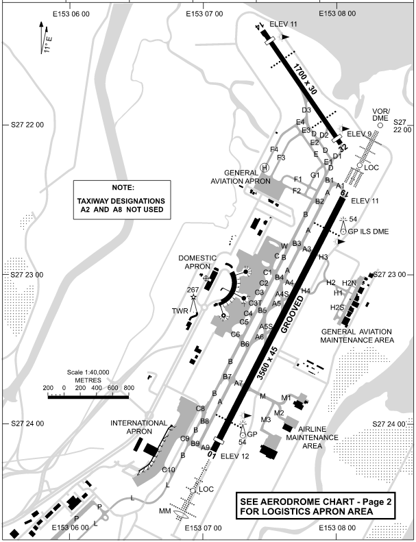
1. At YBBN and other airports most airlines only use high speed taxiways such as A5S, A4S, A6 & A5. See diagram. Now that you're able to control AI to the gate is there any way (perhaps a maximum aircraft weight assigned in the AFX/AFD/AFCAD taxiway files) to ensure airliners only use certain taxiways. Also in YBBN departing aircraft taxi out via taxiway B and in via taxiway A (or vice versa <- I need to verify which way round it is).
2. When I was learning to fly in Australia often times for traffic spacing (we'd be flying Piper Tomahawks at 70-90kts while F-111's were in the circuit), the tower would instruct us to do an orbit (on the downwind leg). If AI controller had control of any aircraft flying a regular circuit could this be an option to include to help with spacing? Basically an orbit is a 360 degree 2 min turn just to add spacing in the circuit. This is similar to what you're doing with SIDs/STARs. Might be cool in future if this was an option as well. (Just a future wishlist item but not critical).
3. Would it be possible to make the SID/STAR procedures operate on time of day? e.g. some airports have noise abatement procedures at night, so AI Controller turns off all daytime SID/STARS and only uses the ones authorized for certain hours of operation.
Questions:1. Much further into the future, how hard would it be down the track to develop a dumbed down version of AI controller (maybe a separate app) to control A) ground objects (i.e. move object "animated elephant" from waypoint 1 to waypoint 2...... to waypoint 33? B) ship/vessel traffic? One would allow us to add in animated wildlife into the sim anything from the animated wildlife (currently only available in the missions), to moving people, to custom non-road moving vehicles, to kite surfers or even surfers on waves, or even golf buggies on golf courses. Even further it could be used to place satellites in space (or at least an effect) so we can see moving satellites blinking across the sky at night.
2. Does anyone have a good UT2 .ini configuration for AI Controller? I'm about to start tinkering
3. I was just looking at Guam (AB WonPat) International Airport (PGUM) and noticed it doesn't have any SID/STARs but only uses IAP's with ILS, RNAV (RNP), RNAV (GPS), TACAN, VOR, VOR-DME and NDB/DME arrivals. Would AI Controller be able to handle any of these types of approaches? I'm assuming RNAV yes but the others not yet? https://www.airnav.com/airport/PGUM4. At YBAF where I learned to fly they separate ATC frequencies based on departures North and South (i.e. 10L/28R is 123.6 and 10R/28L is 118.1). Would it be possible to use AI Controller to set the inbound points (mt Cootha, Target, Swanbank etc) and direct traffic to specific runways for each frequency. I'm still not clear on my question here, so please bear with me. I can clarify further tomorrow (my head is foggy after 57 pages of AI Controller posts)
Humbly Yours and with Utter Respect,
Dean, -
I've been seeing them a lot lately. Would love to replace the texture with something more realistic...
-
I know exactly what it's like by the harshness of some in the FS community. 98 out of 100 people are wonderful, but the detractors can make your life hell on earth and not want to go on. Steve if you read this, I've been there. You just have to stay true to your vision. Maybe even finding a few trustworthy people who can be your support team.
The other alternative is, if commercially it's not viable, then how about open sourcing your code? You could still generate your own software in-house that you could sell, but at the same time others can jump in and develop your code further reducing your burden.
BTW I just downloaded the shader_release_v3.2.3 and it's fixed an issue for me with DX10 and alpha channels on the textures. Works great.
-
Many here may remember Paul Roussin from the FSX Beta Team. Paul is the author of GammaPro which is by far the best screen recording software.
Paul was diagnosed with terminal cancer not long ago and we lost him for a few minutes the other day.
Here's the transcript of his email to me.
Feel free to pass on.
What a birthday party I had, Important people from all over Syracuse come to my party.
As Al said I passed out standing up. It was about 5:30AM and I got off the couch to go to bed. As soon as I stood up everything turned brown and I felt myself in free fall. The timing of passing out was the time it took for my retinas to fade into darkness (perhaps 250 milliseconds???). The brown color was the filtering of the light through the blood of my eyelids. I have no recollection of hitting the floor.
I woke up later lying next to the top of the staircase staring into the stairwell wondering where I was. I have no idea how I got there unless I tumbled over the end of the couch. There was a picture on the wall of a vase of flowers and I realized I was in Kim’s house. I was laying on top of my left arm and had to roll on my right side to free my arm. I could not get up nor could I yell loud enough to awaken Kim(no air).
I finally maneuvered my feet down two steps of the stairs and used the railings to stand up. It was a frantic move to reach my bed having to use the tricks from childhood of falling forward. I made it to bed and laid down on my left side and went to sleep; bad move I should have gone to the hospital, but I had no idea of the trouble I was in.
Kim came by about 9:30 and I told her why all the lights were left on and apologized for vomiting on her rug. Later she called the Oncology center asking for advice and they told her to dial 911 or I would die.
At the emergency room things got really bad I began gasping for air not getting any because of the breaths being too shallow and I began dry vomiting every breath. The people in the emergency room saw me and respectfully turned away figuring I was in my death throes and was leaving. However I rolled over onto my left side and my breathing settled down and the vomiting reflex stopped. It was a very terrible moment.
The ER doctor asked if I had urinated at home lying on the floor and I said yes I was soaked(that has never happened before). He asked if I defecated and I said yes. He said I had died and the oxygen starved brain had stopped sending and receiving signals to and from the body. I was medically dead. He has no idea how I came back except that the fall may have moved the blood clot allowing blood into my lungs again. He also tried to figure out why laying on my left side was helping me to stay alive but said it has to be allowing blood into my left lung.
Kim, Al and Trudy came in later and I feel bad for the frenzy they must have witnessed. I was too busy fighting for air to be scared but they must have gone through hell as the ER was Helter Skelter.
The ER doctor decided to cut through all the procedural steps and relied heavily on his experience that I must have had a blood clot which was still blocking my breathing. He rushed me through a CT scan and they found one of the largest clots ever. It was so massive that it could not enter the lungs but had completely sealed them off except for the subsequent leakage that allowed me to live. Then he gave me the TPA medicine which broke up the clot. Later that night I noticed I could lay on my back and still breath. http://www.nlm.nih.gov/medlineplus/ency/article/007089.htm
Apparently this made lots of gossip and I had several heart doctors pass by to see if I was really alive. No one could believe anyone could have survived such a massive attack. I am called the Miracle Child. There were many quizzes testing to see if I had suffered brain tissue damage but I seemed to be fine. I will leave other details out,
Alfred came by every day and it was really helpful to see him. Trips to the hospital are not fun but he was there,
I did not see any white lights nor dancing ladies in white dresses running through fields of grain, I was gone and further with a dead brain there was no mechanism to record anything; I will never be able to remember hitting the floor. Perhaps if Hollywood offered a few million dollars I could yell out, “Oh! Wait! I remember something!”.
There was absolutely no pain at all, it was just as if the power went off in the middle of the night and came back on later; that was all. It was a beautiful death in that sense.
The clot was caused by the tumor which by controlling the liver alters the body chemistry and makes clotting in the legs highly probable which makes me ask why I was not placed on blood thinners to start with. Perhaps things were bad enough without adding yet more complications.
They brought me to surgery to put what they called filters into my returning veins. Because of my low blood pressure they could not give me a sedative and I waited and waited for the pain of the surgeon’s knife. Finally I asked, “Have you made the cut yet???” “Are you crazy!” the voice came back, “I am deadly afraid of blood!” What they did was push a pregnant needle in my leg vein (groin) and used wires to push it up to just below the heart and they released the filters which have spring loaded wires that hook the vein and stay put. The structures unfold into what looked like French Fry baskets of crisscrossed wires. I could see them on the real time x-ray machine; really neat. They filter all the returning blood. They said any new clot would get trapped and the body would dissolve it via digestive type enzymes. I am now a new improved incremental model version 2.0.
Tomorrow I get a CT scan to check on my dear friend the ever sinister colon tumor that threw me such a severe knockout punch. I will get the results on Friday. I will send out a follow up report.
Kim has been my greatest friend through this and her attention is beyond imagination. I can’t say enough about her.
What did I learn? Nothing philosophical, but it was one hell of a lesson in humility. Me a mighty warrior can be brought from full life to a full death in about one second; that is fragile! It was no Hollywood death where you linger about kissing all your girlfriends goodbye, it was lights out period.
I was placed on Coumadin (warfarin) and Kim was giving me two shots a day in the stomach. Yesterday they tested my Coumadin levels and told me to stop the shots. What a relief for both Kim and me.
Remember, Enjoy yourself for you only live twice!
Paul The Miracle Child.Paul's email address is proussin AT verizon DOT net and I'm sure would love to hear from everyone how much he is loved. Please drop him a line, he's a great guy who's life light is about to go out.
Sincerely,
Dean. -
Not as yet, but are there any DX-11 3d drivers (non-nvidia) that exist? Mine are only DX9
-
So soliciting feedback from the community about something that hasn't been done before on a large scale, and swapping ideas and discussing a project apparently seems to be what you're missing here... I am posting exactly in line with what Tom said this forum was about... <g>This forum was suggested by our members, and we are happy to set it up. This forum is a generic Photoreal forum by request. That is, it is a forum where commercial vendors can discuss their projects, and users can get help, swap ideas, and put their toe in the water to see if they might like creating Photoreal addons. Welcome aboard! -
How is posting video of photoscenery in a commercial photoscenery forum promoting a company? It is photoreal scenery for Guam. The video is of something that has not been done on a massive scale before a complete audio environment for photoscenery over a massive area in FS. On a side note, I'm a sole developer who has had zero income for 2 months now due to all my other product lines having to be shut down due to piracy, I'm living in the third world helping the poor and needy at the same time. I need to eat next week and pay rent and pay $223 for web hosting fees to support the FS community, I'm down to my last $50 and I have a fiancee and 5 soon to be sister in laws. After nearly 25 years I still fail to understand why some people in the FS community seem to have such a bad attitude towards any commercial add-on. It costs money and time to develop this stuff and it costs money to make this stuff and host it and serve the community. Figure out my costs here... $223 per month to run the website, $100 per month for electricity, $100 per month for internet, 30% of sales go to stores. I'm not in this for profit, I never have been, I've been in this to do stuff for the FS community that would not be possible otherwise. I've been working 16 hours per day almost 7 days per week laying down my life for the poor and needy in the Philippines and also trying to serve the FS community and it's responses like the above that make me want to say forget it.

 We already run about 10 different processes to the imagery improvement process. Adding any extra processing to each image could mean each state takes twice as long to render and twice as much cost in terms of electricity and computing power, which would then increase the cost of the product to be outside of the reach of any of us, including me.


Words I need to share with our Community
in Hangar Chat
Posted
Tom, love and prayers from Melanie and I. Your love, dedication and support of the entire flight simulator community has been above and beyond the call of duty. If there's anything we can do, please let us know.
Sincerely,
Dean & Melanie Mountford.