


gcltlee
Members
-
Joined
-
Last visited
-
-
Hi Guys, Does anyone tried to use Flight One GTN750/650 shoot the GPS approach in Citation, I was trying to shoot GPS approach in KFAT, I pre-select GPS(LPV) 29L approach which gonna give me vertical guidance generally but this plane may not work properly,so I disconnect A/P after passing FAF,then I hear Glide Slope Warning when I try to descent as normal, I realize the vertical guidance may work so I landed then tried another approach, active the APP mode after start my initial approach point, this time the VSI started to move back and forth, the plane is totally not stable, plane descent over 1500fp and terrain warning occurs, I have to disconnect A/P manually approach. My question is where the Glide Slope indicator come from in the PFD when I shoot GPS approach? There is no ILS signal on that runway so I just confused, second question is how to mute the G/S warning when shoot GPS approach ,thanks ! Qing Li
-
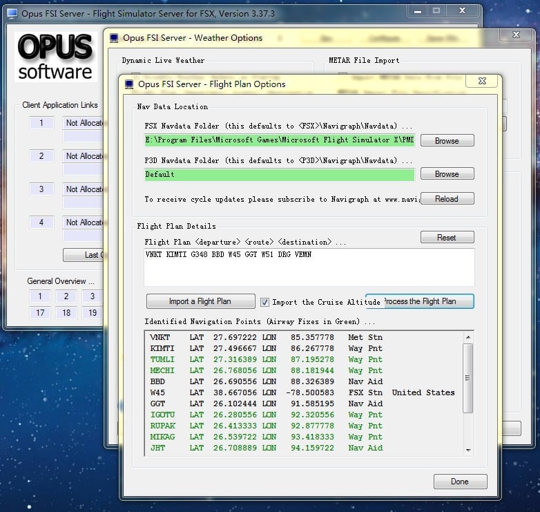
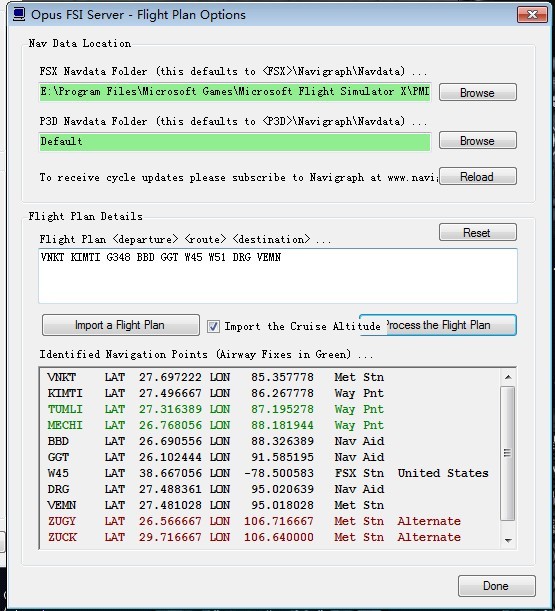
I point out the PMDG navadata folder and I use AIRAC1311 W45 001 KWJ 35.120278 126.800556 W45 002 VENUS 35.125000 127.582222 W45 003 AMICK 35.125278 128.497778 W45 004 PSN 35.122500 128.999445 W45 005 SGR -16.441647 -39.082472 W45 006 GAXAM -16.815333 -39.658500 W45 007 DADNA -17.542333 -40.793833 W45 008 ATIMI -18.618000 -42.521167 W45 009 OPLUT -18.860667 -42.903500 W45 010 ANLES -19.189333 -43.440000 W45 011 CNF -19.558214 -44.048514 W45 012 BHZ -19.835770 -44.003564 W45 013 AKSUG -20.365667 -44.348333 W45 014 TENIM -20.755500 -44.600000 W45 015 ARENA -21.026667 -44.782500 W45 016 NIGMA -21.167000 -44.872834 W45 017 GIKTU -22.046167 -45.462000 W45 018 MUKSA -22.116333 -45.507667 W45 019 SIDUS -22.767500 -45.947000 W45 020 TEXAS -23.093500 -46.171833 W45 021 BCO -23.406428 -46.385464 W45 022 RDE -23.891000 -46.528167 W45 023 NEROK -24.274667 -46.745833 W45 024 PETRI -24.802500 -46.987834 W45 025 VUKUS -25.913356 -47.558725 W45 026 TUVAM -27.163833 -48.215833 W45 027 FLN -27.669917 -48.540453 W45 028 LRS 11.944667 -66.671250 W45 029 VARGA 11.245556 -66.595278 W45 030 JUREL 10.969750 -66.567028 W45 031 VVC 4.066944 -73.382222 W45 032 VIDAL 4.316667 -73.355556 W45 033 MIGAN 4.723056 -73.311945 W45 034 BLI -8.750570 115.163306 W45 035 ENTAS -7.712956 114.370292 W45 036 SBR -7.373939 112.771220 W45 037 BA -6.966667 111.416667 W45 038 ANY -6.974522 110.379983 W45 039 PIALA -6.790358 109.136817 W45 040 CA -6.697981 108.559758 W45 041 KASAL -6.543992 107.940584 W45 042 HLM -6.271944 106.886975 W45 043 DENER 15.456667 -25.692222 W45 044 SVT 16.829156 -25.064625 W45 045 DOSON 73.517500 80.380000 W45 046 PESIK 75.650833 91.498889 W45 047 USATO 76.200833 99.049722 W45 048 MELUS 77.717778 104.233333 W45 049 SPL 43.496581 16.304722 W45 050 SAL 43.937861 15.168108 W45 051 MINTU 44.340000 14.695556 W45 052 LOS 44.527097 14.472847 W45 053 CRE 44.902881 14.416547 W45 054 KULEN 45.165278 15.133611 W45 055 LLK 26.762195 80.880472 W45 056 BODOG 26.026944 83.581945 W45 057 PPT 25.590417 85.089917
-
the above picture is the test to see here is an actual FP
-
In this attachment the W45 airway was identified by opus but it's not a waypoint, in addition the X and H airways across China can not been distinguished by Opus Hope you guys can solve this issue soon thanks
-
Thank you for your proposal!But sorry for that, for example LinzhiAirport Final APP FOR rwy 23 will fly arc R 5NM track into the valley to land rwy23, i was written according to Linzhi RNP chart data in FSX then test,however in the FINAL APP the egpws was caution terrain, i want to change APP track but i dont knew when will it caution, so i need to knew the mode of egpws, it can help me to finish off it. :lol:
-
Hi, everyone: in the past few days, i I have written the RNP Sid/Star program For CHINA.LinZhi airport, but in final App the EGPWS was prompt Caution Alert with Waring Alert, I tryed to changed Arc track and check track again but i dont kenw when happen with it. and pardon my english, :rolleyes:

