Jump to content
Sign in to follow this  
  • entries
    56
  • comments
    7
  • views
    33,884

About this blog

Random flight simulator musings, review addendums and flight logs

Entries in this blog

Gaiiden

Sun Up and Sun Down

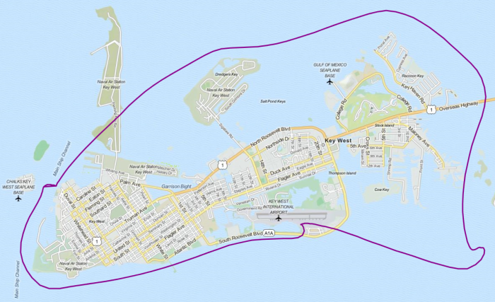
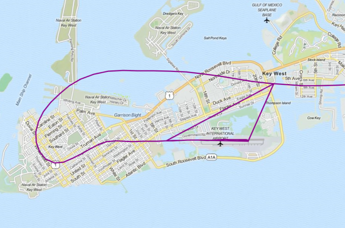
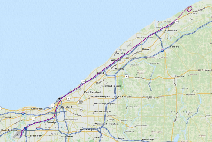
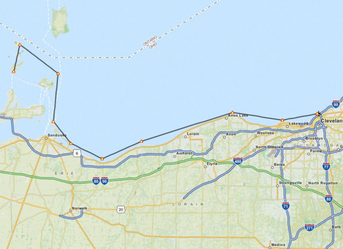
Finally took my first flight of 2014 since I returned home from Dubai. I knew what I wanted to do for a flight but getting around to it took a lot more effort that I thought it would given the nature of the hobby of flight simulation. Plenty of stuff happened while I was away, so first I had to catch up on product updates and try some new mods to the SkyMaster and the sim in general I picked up on in the interim. I also had to download, install and configure the latest REX texture product - which has amazing textures but I found it a bit disappointing that you can only install every texture in a theme pack instead of just the ones you want. To do that you have to install them individually, which is a bit of a pain. It's especially puzzling since this was a feature in the previous REX texture product. I also had some extensive work to do with the Bahamas Airfield Package I'm using to get the most out of this area of the Caribbean. For some reason pretty much all the airports have tower and ground frequencies, some with approach as well. Actually, the majority of them should simply include a unicom tuned to 122.8 for common traffic advisory. So I had to edit and recompile in ADE all the airports north of Nassau that I would be flying around for this flight. Then too I needed to make voicepack files for the airports so I could keep proper track of where planes were. All in all though these changes made for a great flight so I can't complain, and the author of BAP and I are in contact and I will most likely be passing my improvements on to him for a new release.


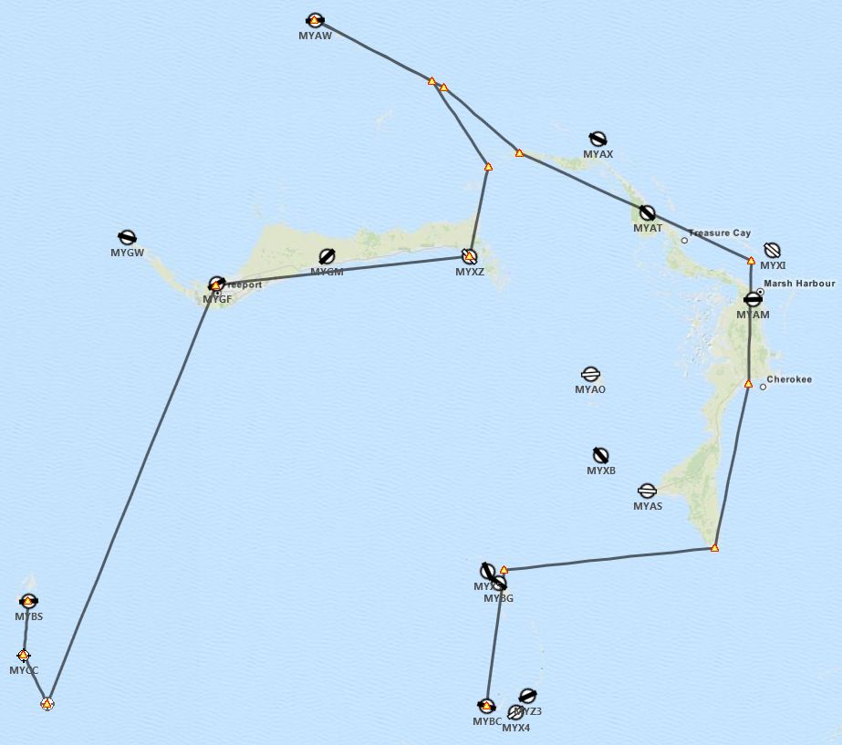
Right, so the flight. I originally planned for a single flight up to Walkers Cay (MYAW) but wanted to get a full experience from the new REX textures, especially the sky textures based on screenshots I've seen on their forums. So I extended the flight and broke it down into two legs, one to fly at sunrise and another to fly at sunset. The only difficult thing about planning the second leg was finding an airport that was lit and also easily navigable to since once it gets dark seeing the smaller islands can be near impossible. Thankfully the southern-most airport still north of Nassau, Chub Cay (MYBC), has a lit runway and is easy to find at the end of a chain of islands. Here was my original plan:


T_plan.jpg

Leg 1: Sunrise


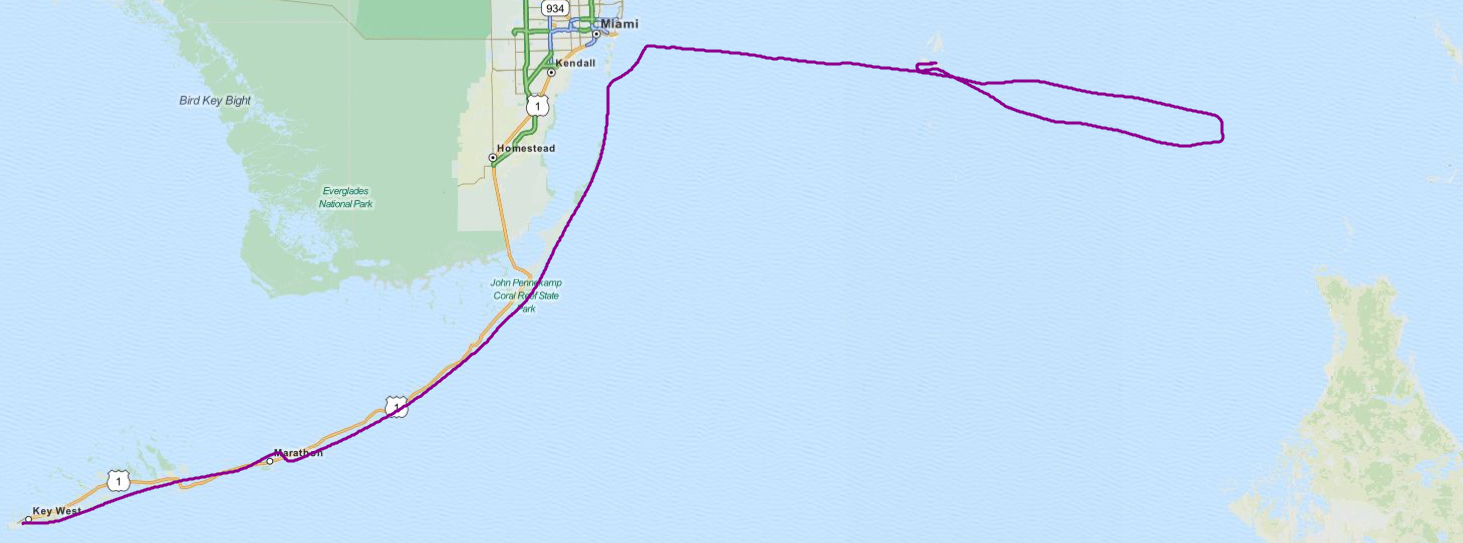
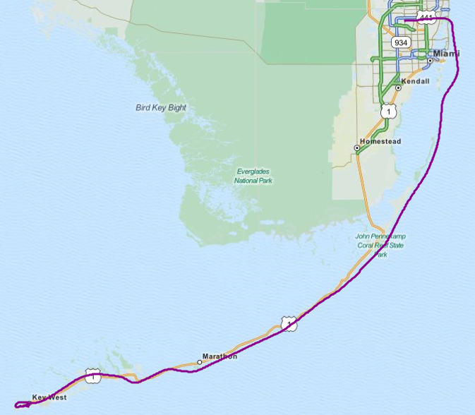
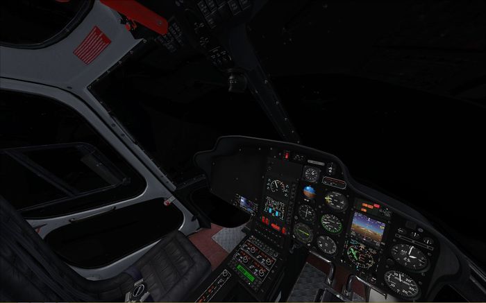
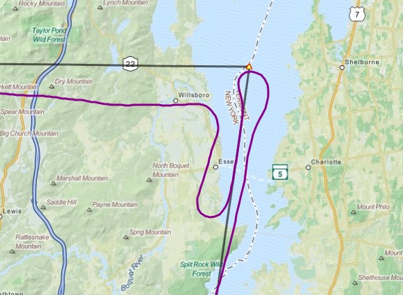
After preflight and taxi out to the runway I checked the sock and saw a crosswind. I decided to take off west and of course as soon as I begin to taxi down the runway a plane announces it is a few miles out inbound to land out of the west. I made it to the end and was considering parking on the grass and waiting but the pilot updated his position and was still a few miles out so I turned about, skipped my engine runup and just went straight into the takeoff. I was climbing out and turning south while he was still over 2 miles away so that worked out alright. Clouds were low, so I kept it around 1,000 feet as I cruised towards the two small islands south of Bimini to have a look-see. One of them, North Cat Cay had a carrier group stationed offshore, which was cool. The southern-most one, Ocean Cay, looks like a man-made affair still under construction. No idea what for though. I did a loop around Ocean Cay back up past North Cat Cay rather than departing straight for the Freeport VOR as originally planned, but VFR plans are meant to be broken, I say!


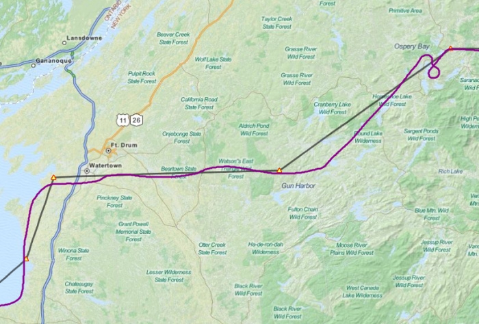
The clouds didn't let up by the time I reached Grand Bahama Island so I needed to request permission for Class D airspace transition. I left the VOR behind and switched to terrain navigation, following the south shore of Grand Bahama until I reached Deep Water Cay and headed north along a chain of islands towards Walkers Cay. There was plenty of traffic elsewhere, mostly Treasure Cay and West End, so the pattern was clear when I reached Walkers Cay and was able to enter straight into downwind with a nice turn to base and final lined up with the runway. I dropped full flaps since the runway was only 2,500 feet long and to complicate matters there were two rather tall pine trees right at the runway threshold I needed to clear. But I got her down with a heavy bump and only needed some light braking. The runway turns straight into the short taxiway leading to the apron so that helped extend it a bit as well.


Leg 2: Sunset


I climbed back into the cockpit an hour and a half before sunset. The clouds were still low but they were more scattered, so after takeoff I made the decision to climb above them since there was only one layer to deal with. I hadn't flown the 337 higher than a few thousand feet so getting up to FL150 was a new experience. I adjust the prop pitch slightly to keep my RPM in the green and I was able to use the fuel flow gauge to properly lean the mixture - too high or too low and you saw the fuel flow drop. I kept an eye on my EGT gauge but the needles stayed nice and low. I was at full throttle and my manifold pressure was almost out of the green arc - too bad this airplane isn't turbocharged. Still, I managed to make 130kts as I cruised over Great Abaco Island. As the sun started to descend, so did I so as it got darker I would be able to still see the smaller islands I would eventually be following. I was supposed to fly to the tip if Great Abaco and vector out to the Berry Islands but decided to follow the Great Abaco Highway instead, which would point me to the northern-most island in the Berry chain. There was also an arriving aircraft into Great Harbour Cay that made it easy to find the north islands. Also, the SkyMaster has a GPS and while I wasn't using it to follow a track you can see the islands on the screen to help with navigation.


It was almost fully dark as I approached Chub Cay, the island at the end of the Berry chain. While I hadn't heard a single plane on approach to Chub Cay, wouldn't you know that just as I'm turning south to follow the island chain and call out my position someone else also declares their intent to land. Fortunately they were a bit closer and making a direct approach so that gave me time to meander down the chain and set up for a downwind pattern leg, which by the time I got there the other guy had just landed. I didn't hear him call clear of the runway so I he probably disappeared because no parking spots were open. Still, I kept my eyes peeled on final after rolling out a bit late from my base turn and needing to S-curve in a bit. I don't think I even really noticed the trees on the small island on my approach until I looked later at the screenshot - shows how experienced I am at night flying. Fortunately I skimmed them but didn't hit them. There were no obstacles short of the threshold so I was able to make a nice shallow approach and had a much smoother landing this time with only a notch of flaps needed as this runway was 5,000 feet. I rolled out short of the end and turned about without needing to brake and taxied back to the apron where I parked.


T_trail.jpg

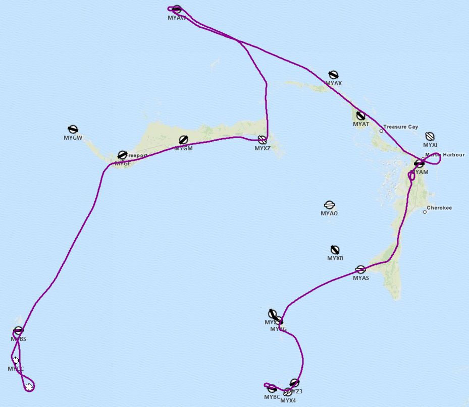
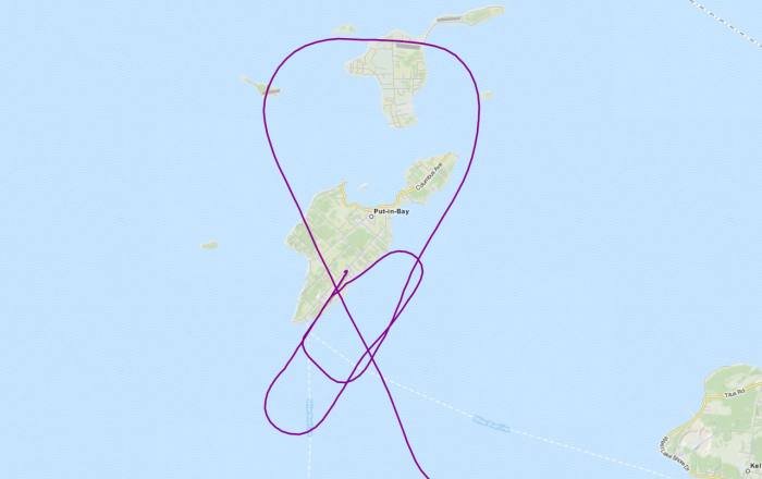
You'll notice some loops in the trail over MYAM as this is where I descended within a gap in the cloud cover so I needed to spiral a bit to stay in that clear area away from the clouds. Other than a few other deviations previously mentioned the flight went according to plan.


Next up, I will be flying a loop around the central Bahamas, ending up at Nassau. I plan to stay put for a few flights from Nassau to the surrounding islands in a few different aircraft before moving on south.

Gaiiden

Given that I'm about to install FSX on a clean computer for like the 4th time and still don't entirely remember all the stuff I've done with it over the years I decided to create a log here to chronicle all the additions and tweaks I make so that next time a clean build is required I can just follow the steps rather than trying to remember what to install/tweak next. It's also a way for others to get ideas for tweaking their system and FSX products as well.


Things to Back Up on Main Drive

  • Ultimate Traffic 2 databases - primarily ones I've created
  • Standards.XML
  • FSX.cfg
  • Flight Simulator X Files folder
  • ENB mods
  • Saitek device profiles
  • FSWC profiles

Initial install procedures and additional tweaking taken from NickN's all-encompassing guide

Additional information used for tweaking gotten from the AVSIM FSX Hardware & Software Guide


Uninstall Note: FSX Acceleration is installed on top of the default FSX install and only one at a time will show in the Programs and Features window. So after uninstalling Acceleration go back and then you can uninstall FSX


4/10/14 - FSX Deluxe Edition installed

  • Program run after install to create folders

4/10/14 - FSX Acceleration Pack installed

  • Program run after install to activate, update settings, create new folders
  • My Documents/Flight Simulator X Files replaced with backup
  • Standard.XML control file replaced with backup
  • ai_player.dll modified for AI timeout extension - do not replace with backup from previous install
  • fsx.cfg replaced with backup
  • ENB series replaced from backup (using John Venema's settings - set EnableBloom=0 under [Effect])
  • Use these settings for good image quality/performance

4/10/14 - ORBX BOB installed

  • Required for my default scenery design flight scenario

4/10/14 - FSUIPC installed

  • Make sure to register at end of install - license key in email

4/10/14 - Confirmed the Windows Aero framerate tweak still works

4/10/14 - Converted system to DX10 preview mode

4/10/14 - Real Environment Extreme Essentials+ Overdrive installed

  • Installed REX Auto Updater, updated to latest version
  • Restored settings
  • Initial texture install

4/10/14 – Installed REX4 Texture Direct HD

4/12/14 - Shade installed


4/12/14 - Soundstream installed


4/12/14 - A2A Accu-Feel installed

  • Upgraded to 2.0
  • Disabled turbulence modeling

4/12/14 - Ultimate Traffic 2 (SP2) installed

4/12/14 - A2A ShockWave Lights installed

  • Updated to 1.2
  • Default C172 modified to add taxi light and remove beacon flash from cockpit view:
    light.4 = 1, -20.51, 0.00, 6.20, fx_shockwave_beaconh_lowl
    light.7 = 6, -1.45, -9.1, 2.6, fx_shockwave_landing_light_narrow_down_22
  • Add shockwave strobes to UT2

4/12/14 - Tweaked Maule and Cub turn radii

  • For tighter turns in Maule AI aircraft overwrite in aircraft.cfg [contact_points] with this:
    point.0 = 1, -8.0, 0.00, -3.5, 1500, 0, 0.36, 350.0, 0.3, 2.5, 0.7, 0.0, 0.0, 0
  • For tighter turns in Piper Cub AI aircraft overwrite in aircraft.cfg [contact_points] with this:
    point.0=1, -6.00, 0.0, -3.6, 1800, 0, 0.238, 350.0, 0.300, 2.5, 0.40, 0.0, 0.0, 0.0, 0.0, 0.0

4/12/14 - Installed FS Global Ultimate The Americas


4/16/14 - Re-implemented some stuff from Install #3

  • Flusifix tweaks
  • HD Moon
  • Edit Voicepack
  • Touchdown effects
  • Environmental Reflection X

4/16/14 - Installed Carenado Cessna SkyMaster 337H

  • Service pack installed
  • aircraft.cfg modified to allow ATC to callout aircraft type/model - "atc_type=Cessna" and "atc_model=C337" (under [General] section)
  • Need to add atc_id to any fltsim profiles used
  • Shockwave light settings

Previous Install #3


11/6/13 - Ultimate Terrain X USA (v1.2b) installed

11/6/13 - Super Traffic Board installed

  • Update to SP1A to allow connection with latest UT2 database (Summer/Fall 2013)

11/20/13 - EditVoicePack X installed

11/20/13 - various FSX effect, environment and aircraft tweaks

11/20/13 - FS Water Configurator installed

  • HD Wave animation (set 2) installed and activated
  • Moon Specular 30%
  • Moon Glow Reflection 10%

11/20/13 - FTX Global Base v1 installed

11/20/13 - FlusiFix-2006 V5.0 installed

  • Increased AI taxi speed
  • Weakened snow taxi effect
  • Edited power line masts

11/20/13 - Installed LatinVFR Key West

11/20/13 - Installed Miami City X 2012


11/20/13 - Installed AI Ship Traffic for the world


11/21/13 - Installed Ultimate Terrain X Tropical American and Carribean

11/22/13 - Installed Instant Scenery 3


11/23/13 - Dodosim Bell 206 installed

11/25/13 - Installed TropicalSim 15 Caribbean Airports Pack

  • See email for alternate Addon Scenery/Scenery TCNM file

11/25/13 - Installed Bahamas Airfield Package

  • Edited out tower freq for MYBS

1/16/14 – Installed FTXVector (will replace UTX on future installs)

  • Ensure FTXGlobal is at least v1.2


Previous Install #2


8/21/13 - Airport Design Editor installed

  • Copy over Thumbs and Generic Buildings folders from backup
  • Copy over dat/ini files from /FSX folder from backup
  • Pro Key reg in email
  • Big Thumbnail Pack for default scenery objects

8/21/13 - Whisplacer installed

  • Really just have to re-export objects as long as original folder is intact

8/21/13 - Wally-Bob's NJ 5m Mesh installed

8/23/13 - SunSkyJet KPHL installed


8/23/13 - Carenado V35B installed

  • aircraft.cfg files backed up
  • Optional patch applied - aircraft.cfg [lights] and [fltsim.x] sections restored from original files
  • Shockwave lights settings applied
  • aircraft.cfg modified to allow ATC to callout aircraft type/model - "atc_type=Beech" and "atc_model=BE35" (under [General] section)

8/23/13 - Drzewiecki Design New York City X installed


8/24/13 - RemoteFlight server installed

  • For use with HD radio stack on iPad

8/24/13 - Plan-G installed


8/24/13 - US Cities X Buffalo/Niagara installed

  • Moved outside of FSX folder after install

8/24/13 - FlyTampa KBUF installed

  • Moved outside of FSX folder after install

9/8/13 - Installed CeraSim Bell 222

9/8/13 - Installed Helicopter Total Realism 1.5

10/2/13 - Installed KGFL


10/14/13 - Installed Nemeth AS355

  • Repaint FedEx (add fallback to Texture.2 in texture.cfg)

10/19/13 - Installed NorthEast Fall scenery to retain foliage colors through October


10/26/13 - Installed US Cities X Cleveland

  • moved outside of main FSX folder
  • need to compile out Tower frequency from 3W2 & 3T7
  • works well with OhioX for Cedar Point scenery (need to disable 3W2 that comes with it)

10/28/13 - Installed Alabeo D17 Staggerwing

  • aircraft.cfg modified to allow ATC to callout aircraft type/model - "atc_type=Beech" and "atc_model=BE17" (under [General] section)


Previous Install #1


FSX SDK installed

  • Note: install creates an "SDK" folder inside the folder assigned for install
  • Installed using this guide from FSDeveloper
  • Needed to transfer files off disc for setup

MegaScenery Earth New Jersey and New York installed

  • Make sure to layer UT water above MSE scenery so that all lakes are properly exposed to FSX water

Confirmed the Windows Aero framerate tweak works

Aerosoft Manhattan X installed

  • Moved outside of FSX folder after install

Installed Nemeth AS350 from Hovercontrol

  • Primarily for use with Heli Traffic

Installed Bell 206 Longranger from Hovercontrol

  • Primarily for use with Heli Traffic

Installed GMax Agusta 109 from Hovercontrol

  • Primarily for use with Heli Traffic

Installed Agusta 109 from AVSIM

  • Primarily for use with Heli Traffic

Installed Bell 407 from Hovercontrol

  • Primarily for use with Heli Traffic

Installed Bell 430 from Hovercontrol

Installed Schweizer2 300C (1 & 2) from Hovercontrol

  • Primarily for use with Heli Traffic


Gaiiden

Tropic Thunder

For my last flight of the year I wanted to make it to the Bahamas so that next year I could launch on a grand tour of the islands as I continued to move south in the Caribbean. My chosen destination for this was Nassau, given that it hosts the largest airport and that airport is rendered by a TropcialSim addon I purchased as part of a 15-airport pack for the Caribbean in a sale on SimMarket. I did a check of the weather and although things were a bit rough around Miami I was just going to be passing by so didn't expect to catch the worse of it. I climbed back into the SkyMaster, ran through my preflight and got taxi clearance to the active behind a Southwest airliner taking off. I pulled up to the hold short and radioed the tower for clearance but they had me hold for arriving traffic a few miles out. While that traffic was approaching another aircraft announced landing intentions and ATC gave them clearance. Then another. These aircraft were like 3-5 minutes out each but ATC wouldn't slot me inbetween. Finally after holding for almost 15 minutes waiting for three aircraft to land ATC cleared me for takeoff.


Cloud cover was low so I only cruised around 1,000 feet and the light rain stopped a few miles from the airport. I had my comms tuned to the CTAF that Marathon was part of so when I neared the airport I realized I was about to cross the landing paths of incoming aircraft and swung a bit more northward to pass west of the airport, then I crossed over the runway to get back to the eastward side of the keys. Around this time things started to get a little bumpy and I had to throttle back from 160kts to 140kts in case of sudden severe turbulence as 160kts is just under the yellow arc. From this point on I was mostly 140-150kts depending on how the air was behaving. I had a few more bumps before arriving offshore of Miami and turning east to vector towards Bimini, the western-most islands of the Bahamas. Clouds remained low and closed in to overcast with only about 10nm visibility, but not rain.

The leg to Bimini was a bit tough since I don't use autopilot. The horizon was very unclear thanks to the low cloud cover and reflection of the water so it was hard to know when I was banking slightly unless I kept an eagle eye on my instruments. I was tracking a VOR vector from the Miami area even though Bimini has its own VOR so when I finally arrived at the island I was about 2-3nm south of it. But still not too bad, I wanted to see whether I could hit a target from a vector since the majority of these islands don't have their own VORs for me to vector in on. I then vectored outbound from the Bimini VOR to my next leg, which would put me in the middle of the Berry Islands north of Nassau and let me vector south towards the airport along the main runway heading for an easy straight-in approach or pattern entry.

However about 20nm into the 80nm leg to the Berry Islands from Bimini I noticed lightning quite frequently off in the distance. I pulled up the REX weather radar and it didn't show any thunderstorm activity ahead of me. I checked the weather at Nassau on the web and it didn't give any indication of thunderstorms. I pondered over whether I could head south and try to swing around the storm and then head north to Nassau but I had no information about this storm, like the direction it was headed it. I could run into it on my way north to Nassau. What the hell was this storm even doing here? Well, I figured it was just because this was the Bermuda Triangle after all, and sudden storms are known to coalesce. Given the Triangle's reputation, once I started seeing lightning light up my cockpit and hearing thunder I did an about-face and headed back for Bimini!

There's a small airstrip on Bimini that can handle my aircraft easily so that's where I put her down once I got back to the island, leaving the storm behind. The airfield is not supposed to have a control tower but it did, no doubt a mistake on the part of the author of the Bahamas Airfield Package I downloaded to get better renditions of all 64 airports in the Bahamas. I notified the author so hopefully when I climb back in the cockpit next year there will be an update that removes the tower frequency. I didn't deal with the tower I just disabled AI traffic and landed. I had been wondering though as I approached and passed Bimini earlier why I hadn't heard any action from it on the CTAF.


trail_sm.png


Until next year...

Gaiiden

I got bored of lounging at the beach so decided to check the FBO over at the airport to see if there were any charter flights available. Turns out a family of three that just arrived in port on a cruise ship were looking to meet up with some friends aboard a private yacht arriving at Key West this afternoon. But the yacht wasn't looking to put into port and it had a helipad so the family decided to just charter a helicopter to pick them up from the pad on the cruise ship and ferry them out to the yacht. Man, must be nice to have the dough to splurge on that! Well, at least I get a cut. So I hopped in the Bell 206 sitting on the tarmac and fired her up, took off and skimmed the south side of the key, around Fort Zachary Taylor and landed on the bow of the cruise ship where the family was waiting. My landing was straight in, no wobbles, no futzing - a smooth approach and the softest touchdown I've ever done ever. Which was good cause I had an audience and they were sitting right on the pad!


After I landed I pulled the throttle back but in messing around with Shift+# keys to find a window that would help me open up the doors I accidentally shut off the engine. Oh well, probably safer for the family to board that way anyhow! I finally remembered just opening the co-pilot door up front opens all the doors except mine, so the mom, dad and daughter could finally stow their day-trip luggage and climb aboard. This time I remembered to go into the Fuel and Payload menu to add weight for my three passengers and their baggage. I gave the dad 175lbs, the mom 115lbs and the daughter was 75lbs. Their baggage was only 35lbs. We took off from the ship and circled north around the key to find the yacht. The captain was nice enough to stop for us but apparently ignored my suggestion to turn into the wind. It was a 10kt breeze so even though I approached slightly crosswind it didn't push me around too much and wasn't a real issue. What I did find surprising however was that coming in to land I was having a much more difficult time keeping the helicopter stable on my approach. It wanted to oscillate back and forth a lot, since the center of gravity had shifted further to the rear with my passengers and baggage. Still, after a bit of hovering and nudging around I finally found the edge of the pad and then scraped my skids along to the center to let people out.

Once my passengers were offloaded I went and removed their weight from the Fuel and Payload screen, took off an made the short hop back to the airport, completing a nice circle around the key. Coming in to land at the airport was exactly like landing on the cruise ship - back to the loadout of just me the helicopter was really stable and I made a smooth approach and landing with no need to hover and futz around. I'm really annoyed now I didn't remember to change the loadout the other two times I simulated passengers, the difference is very noticeable! I've always read about how important it is to properly load an aircraft but I've never really experienced it like this before. I'll have to make sure to always remember from now on - I will actually make it a checklist item for pre-flight and takeoff in the helicopters and pre-flight in the aircraft.

trail.png

Gaiiden

Cruising the Keys

Finally cleared up my development commitments and made it through a successful FSDevConf so I was able to focus on getting the sim set back up to fly the SkyMaster again. I got a great deal on LatinVFR's Key West scenery from a sale on SimMarket so I decided that would make for a nice shakedown cross country flight before I headed off across the open sea to the Bahamas. The scenery is overall very good, but it does have a certain lack of quality that makes me glad I didn't pay full price for it. There are several very visible seam lines in the photoreal textures and the textures themselves change quality from sharp to blurry in various areas. A portion of a bay area even shows landclass textures through the water instead of a sea floor. Even the airport AFCAD had a bug in it where aircraft would taxi straight onto the runway and pile up without holding - I had to modify the hold short node position to get the proper behavior. I also added a bunch of additional boats to wake trails that were empty on the photoreal water textures. But again, it's way better than default and even has night textures so I'm satisfied with the price I paid for it.


Anyways, the flight down from Miami to Key West went very well. There was some rain bands moving through the area and I got caught in one for a few minutes about 1/3 of the way down the keys but other than that it was just some low cloud cover I had to avoid. Taking off from Opa Locka (KOPF) I was able to depart straight out to the east and turn south along Miami Beach. I used the Dolphin VOR to stay 14nm distant and remain outside of the Miami Bravo airspace - the floor above me was 3,000 and I was at 2,500 and within 13nm the floor drops to 1,500. So a bit of DME arcing to the tip of Key Biscayne and then I was free to just follow the coast of the Keys the rest of the way down. I did my best to remain at 2,000+ for the first few keys as that was over a wildlife refuge area marked on the charts. I did have to drop to 1,000 feet as I got further south to avoid a drop in the cloud cover.


I had timed the flight so I would arrive at sunset but I forgot to adjust the time in FSX to account for DST - I need to advance the FSX clock an hour ahead of the actual time to get the proper lighting in the sim. So as I approached Key West and the sun was still above the horizon I went and bumped the time up to sunset. I followed the Overseas Highway since that took me around the naval base and set me up for a downwind entry into the pattern for runway 7 at Key West International (KEYW). I was a little rushed getting configured for landing so I missed looking back for my turning point to final and swung wide and had to S-turn back to line up for landing. Touchdown was pretty good - although like last time I got a little wobbly and came down rear left, rear right and then dropped the nose. I think I just need more power when I land.


trail1.png

trail3.png

Ignore the straight lines - I forgot to disconnect Plan-G before running some replays for landing shots

Gaiiden

Quarry Disaster

So I wasn't able to fly on Thursday, however since the flight I had planned would take place within a relatively small area I could use REX's archive weather feature to load up weather for a given time of day and fly with that. So I found some decent yet not-perfect conditions late in the morning of 10/31 and loaded that into the sim. I had crafted the scenario beforehand with some default objects from FSX and the Acceleration add-on pack. I wanted to do another medevac airlift after the one I did in Niagara, and I originally planned to fly to Put-In-Bay airport out on Middle Bass Island since that had a helipad. The situation would be a critical patient that was driven from his home to the airport to be picked up by the chopper. But then I realized that was a pretty lame scenario and besides, I had just flown there before in the Staggerwing. So I looked around the Cleveland scenery area a bit more. I considered a shooting on the University campus that had photoreal texture coverage, but they have a university medical center and overall the distance was too short. I really wanted to head back out to the islands. Then I spotted this open mining pit on Kellys Island, which I learned was a limestone quarry. I don't know if it's still operational or not but frankly for this purpose I didn't care as the entire situation is fictional to begin with. So I checked out various FSX objects and found one that produced explosions and fires - perfect! Then I just set about a few props, some actors - and I was ready to go.


There are two medical pads in the Cleveland scenery so I decided to depart from one and arrive at another. I chose to depart from the ground pad and arrive on the roof pad because that was more challenging. Plus the hospital with the roof pad was closer on the return trip. I used SkyVector to take a simple bearing from the helipad to the island, which I dialed into my HSI and simply followed that all the way out to the island. The Bell 222 has twin turbine engines, so if one flamed out on me I could continue with the other, no need to stick close to land like I had with the Staggerwing. The direct flight lasted about 20 minutes as I zoomed out near redline at 140kts. The 222 feels a lot more sensitive than the 206 but part of it is the VSI on the 222 is a lot bigger than the 206, so where the needle shows 500fpm climb on the 222 I would read more as a 1,000fpm climb in the 206. So it took me a while to adjust back to that.


I came up on the island without any trouble, the bearing worked perfectly. I circled in to land when all of the sudden I crashed in mid-air. I thought at first I had somehow overstressed the airframe since I was pushing redline the whole way there, but then I noticed the message from the sim stated I had collided with an object, not torn apart my chopper. That's when I realized I had smacked into the bounding box defining the very large explosion area object I had set. God dammit. So after the situation reloaded and dumped me back at St. Vincent's I went into my scenery editing tools and disabled crash detection for the explosion area object like I should have thought to do when I first built the damn thing. Then I had to fly out all over again, but this time at least I was able to approach and land without any trouble. Ok well, without crashing at least. I made a great initial approach but in attempting to spin about to present my loading side to the patient I almost lost it and had to just drop her down and then taxi around to face the right way.


Once I had the patient loaded it was back in the air and back near redline to race back to Cleveland so this guy could get proper treatment. However I realized after the flight that I had forgotten to go into the weight and fuel menu and change the passenger load after I had "picked up" my patient and a medical doctor that would treat and monitor him on the way to the hospital. I realize I also didn't do this during my last medevac scenario. I did think about doing this beforehand this time, but just completely forgot during the actual event. Maybe next time.


I also forgot to make sure I knew where the blasted hospital was for my return trip. Luckily I knew generally where it was and spotted it on my first pass over the area. I belatedly called Lakefront ATIS to get wind direction, which I should have done much earlier, then circled around to approach the pad. ******* crap it was tiny. I managed to make the approach clean and land without having to circle again, so I'll say that my patient was at least alive when he left the helicopter and didn't die while waiting for me to get the bird on the ground. I also didn't jar him into a cardiac arrest as I landed at a gentle 1.4 ft/s. Honestly though in reality I never got to the offloading stage because I went to taxi forward a bit more to turn about and present my loading doors to the hospital roof door and started to fall through the helipad. So I said screw it and captured a shot of me on the pad from the instant replay.


Now, I plan to hop back over to the Cessna 337 down in the tropics but before that I have a ###### ton of work to get done this month and I don't know when that flight will happen. I will be uploading the airlift situation to AVSIM like I did with my last one. The link to download it is here.

Gaiiden

Plant Inspection

The Cleveland scenery package includes a nuclear power plant that has a heli pad, so for this flight I role played as a charter pilot who was hired to ferry a nuclear inspector to the plant for an unscheduled spot check. The inspector arrived from Washington D.C. on a private jet and then transferred over to my helicopter for the final leg of his journey. I found a new paint for the Dodosim Bell 206B that was to my liking, although I tried to find something government or corporation-like first. Other than that there wasn't much else to do to get ready for this flight.


I departed Cleveland International (KCLE) and used interstate highways to lead me first to downtown Cleveland and from there I picked up the interstate that would take me out to the power plant. Simple, although I forgot to orient myself before lifting off so as I rose I had to figure out which direction to head off in! With roads I've learned it's still very hard to tell which road is which - even major highways. Luckily there were lots of other references for me to use as well such as waterways and railroad tracks. I had Plan-G open, which gives me an uncluttered view of the roadways, but I was able to use the Cleveland TAC just as easily to identify where I was. I was tuned to the CTAF while flying and heard a departure call across my route from Lost Nation (KLNN) but was clear before they actually took off.


Upon reaching the plant I did an overfly of the cooling towers - too bad they couldn't simulate updraft, I'm sure it wouldn't be a good idea to do this in real life but that's what makes a sim so much fun sometimes. I circled around to land, there was little to no wind so I just used the circle to lose altitude for my approach. I managed to slow down low over the ground to a walking pace without coming to a full stop hover short of the pad like I normally do. So I made the last few dozen feet at almost a hover taxi and settled a bit rough onto the pad but not enough to bounce or damage the skids - and I didn't futz around either just made an overall smooth and professional-looking approach. I was quite pleased with myself.


I had planned a return trip but didn't have the time for it so this flight ended here. I have one more helicopter flight to try tomorrow if the weather permits.


trail.png

Gaiiden

Day Trip

So the good news regarding my throttle quadrant issue from the last flight is that it's not broken. I noticed the same issue when I swapped it for my newer quadrant and that led me to think of other problems, which eventually made me realize that one of the adjustable controls on my X52 HOTAS was to blame. Specifically it was the wheel that I use to control the throttle on the Bell helicopters, and to do that it is set to the propeller pitch axis. D'oh! But good to know I don't need to spend another $70 on a new quadrant.


I did a lot of prep for this flight, like making sure that I had scenery that would be useful along the way. I noticed I would be flying right past Cedar Point, which contains an amusement park, and I managed to find some scenery that put some simple 3D objects in that area. It wasn't anything sophisticated but it did make it easy to spot while flying for a landmark reference. I've been to the park before and it does indeed have some amazing roller coasters.


I also made sure that all the airports I would tune to for traffic advisories along the way had spoken names, not default phonetic ones, and used EditVoicepack as necessary to ensure this. It's a lot harder to remember the airport designations when flying along and listening to see of there are any arriving/departing aircraft I may need to look out for. While mucking around in EditVoicepack I thought about the fact that CTAF transmission are pretty poorly rendered in the sim. I don't know why I never put much thought towards this before but it's true. Aircraft don't say their type and they don't repeat the name of the airport at the end of the transmission. These are pretty standard rules, to my understanding, so I was surprised to not find any voicepack mods for this in either the AVSIM or flightsim.com download libraries. So of course I just figured out how to do it myself. It's available on the AVSIM library.


I also imported some additional phraseology mods I stumbled across on my search for the non-existent CTAF mod. You can find more on that and the Ohio scenery in my FSX Installation and Tweaking Log.


leg1plan.png

I decided to hop into the Beech Staggerwing produced by Alabeo as I hadn't flown it in one of my flights yet, only for a review. It's a tail dragger, and I normally don't bother with tail draggers because they are a pain in the &@($* to handle on the ground and during take-off and landing but I'll make an exception in this case because the Staggerwing is just a beautiful aircraft and has one of those big rotary engines that just sounds awesome under power, with the deep thrum I can really feel through my subwoofer. It took me a while to get up and going - I wanted to be wheels up with the sun but first I had to troubleshoot the recurring propeller pitch issue, then I realized I never installed the aircraft since I last reformatted my system, and then when on taxi to the active I actually crashed into another aircraft! I don't know why Ground didn't tell me or the other aircraft to stop, like it usually does, but - BAM! So after I reloaded the flight and got ready to depart of course I had to wait a few minutes for the deluge of taxi clearance requests to fall off since the AI traffic reloaded with the sim... and then I just taxied in spot view. Screw it.


Anyways I finally made it into the air about an hour after sunrise and made my way west towards the Bass Island group out on Lake Erie north of Sandusky, Ohio. I kept her low and slow the whole way and it took me about 30 minutes to get out to the islands. On the way I monitored some traffic frequencies and checked in on the weather report before tuning to the CTAF for the airport on South Bass Island, Put-In-Bay (3W2), to see which runway was active. I figured 21, but turned out to be 3. There were three other aircraft arriving so I took a long swing around the islands before entering the pattern to give them time to land and get out of the way - especially because one said it was making for 21, not 3. What I didn't count on was to be on short final and find an aircraft positioned on the runway for takeoff! Honestly, unless I had paused the sim and set up for an external screenshot I probably wouldn't have seen it since by the time I was close enough to spot it I was too nose-high. Fortunately there is a displaced threshold so I still probably would have flown over it on landing had I not seen it. Not sure if it was going to start taking off I announced a go-around and swung back into the pattern. I checked the ATC window and saw no notification of the aircraft taking off so I just shrugged, swung back around and landed over it! Turns out the airport was poorly designed by the US Cities developers and I fixed it to allow aircraft to depart properly.


leg1trail.png

leg1pattern.png

My wonderful pattern work around 3W2. Longer, shallower approach 2nd time to spot & clear the aircraft

So in the real world after I parked and shut down I went off to bed for a few winks but my virtual self was off exploring the islands for the day until it was time to climb back into the cockpit for the flight home around 4pm.

leg2plan.png

There was some more confusion on active runway use when taking off - the sock was pointing at runway 21 but I heard traffic coming in for runway 3 so I hustled to the hold short, rolled and took off from 21 while they were still 4 miles out. I flew back on the opposite side of Kellys Island but other than that the flight was essentially the same going as it was coming. Sandusky traffic was landing from the west so it didn't get in my way and I cruised around FL017 back along the shore of Lake Erie until I was close enough to get ATIS from KBKL and contact the tower for landing instructions. I was hoping they were also landing from the west so I could just fly straight in but instead had to enter downwind to land out of the east. Either way though it's really cool to be approaching from the west and flying past downtown Cleveland. I considered flying back to a different airport in the area covered by the US Cities scenery but the lakefront airport is just too cool to pass up - reminds me of Meigs in Chicago - RIP

I had a weird case of yawing almost uncontrollably off the runway shortly after touchdown and I still haven't really figured out why. I managed to stop before falling off a small cliff in the terrain mesh near the water and had a few good bounces taxiing back onto the runway. Would have really sucked to crash at the end of a flight. I'll have to remember to do a replay of my landing if that happens again - I wonder if it was from my tail wheel touching the ground while it was unlocked. I may have unlocked it too soon and should have slowed down further until I felt my rudder authority weaken. Again, not much experience with tail draggers here...

leg2trail.png

I've got ideas for two helicopter flights, one for the 206 and one for the 222 if I can find time to do them before the start of November in two days. Then it's down south for the winter!

Gaiiden

Slow Going

I realized two things when planning for my next flight. First was that down in the Bahamas I saw fall-colored trees on the islands. These went away at the start of November and were replaced with proper green foliage. The second was remembering that the scenery that comes with Buffalo, Cleveland, Detroit, and Chicago is not made for winter textures, which start showing in the sim at the start of November. So I decided to get in some more flights in the north while conditions were good for them before switching south to the Caribbean for the winter, when conditions are good for that scenery.


I actually considered skipping over Cleveland and Detroit and heading straight for Chicago but when I took another look at the US Cities X Cleveland package I realized there was plenty of value in stopping over here. For one, there's the Burke Lakefront Airport (KBKL) right on the water in front of downtown Cleveland, which makes for a really nice approach. Then there are several chopper pads to stage flights out of and even some islands on Lake Erie to make a $100 burger run out to - I'm thinking in the Staggerwing. I tried looking for a better rendition of the lakefront airport but couldn't find one better than what shipped with the product and had no time to make my own.


plan.png

Download flight plan

I recently re-installed Ultimate Traffic 2 as for some reason it was gradually decreasing aircraft density settings on its own for some reason, leaving me void of any air traffic after a few minutes. While I was at it I updated to the latest traffic schedule as well. This meant that while departing Niagara Falls International (KIAG) I had to wait a couple of minutes for two aircraft to arrive. Actually only one of them landed the second was told to go around. During my takeoff roll I noticed I wasn't getting a whole lot of power. I had enough to take off, and I waited until I had enough for a climb out before rotating just before the end of the runway - luckily there were no immediate obstacles and I was able to raise gear quickly and establish a shallow climb out. I remained puzzled as I checked over my instruments and noticed the RPM indicator was only at 2,000 rather than the normal 2,500 at full power. Thanks to the low cloud cover I wasn't climbing high anyways and quickly leveled off and took another look around the cabin and finally noticed the prop pitch knob was not pushed fully in - even though the knob on my Saitek throttle quadrant was all the way forward. I played around with it a bit and realized that there was an issue with reading the knob position and anything near high RPM setting would cause the prop pitch to oscillate wildly between 2,000 and 2,500 RPM making the aircraft lurch around in the process. So I lowered the prop pitch until it held steady at just over 2,000 RPM and then adjusted my throttle and mixture accordingly. Again, luckily I wasn't planning on flying very high due to a FL035 cloud ceiling so the low prop pitch wasn't a problem worth turning around for.

This does teach me an important lesson however, and that is to always visually check the position of levers/knobs/switches in the sim and not take for granted that operating a hardware control will do the job properly. The fact that I made it off the ground in this case was due mainly to the situation - I was at sea level so had lots of engine power, there were no obstacles immediately past the runway and the runway itself was long enough to build up enough speed to ensure not only that I could rotate but continue to climb out. If any of these things had been different I probably would have had to ditch off the end of the runway or hope I could brake hard enough to stop on the runway - if I had made the decision to do so before attempting the take off anyways and crashing into a tree. And all this could have been prevented had I visually checked and noticed the prop pitch knob wasn't functioning properly prior to takeoff. Or that I wasn't generating max RPM at the start of my takeoff roll.

Again, luckily this scenario played out okay and it just meant I was only able to cruise at just over 130 kts instead of my usual speed of around 160. My plan was to climb to FL065 and go over the Erie Charlie airspace but clouds were low and I needed to stay in the denser air to get as much out of my prop as possible. While passing Erie, PA I tuned to the approach frequency but never saw an option on my ATC menu to request clearance to transit the airspace. So don't know what was up with that - I flew literally right along the shore past the airport where the Charlie airspace reached all the way to ground level. I hit a bit of turbulence after entering Ohio, just some strong wind gusts that would push me around a bit - a few minor up/down drafts as well but nothing really rattling to the airframe and I was heavy with a full load of fuel anyways.

I had also re-installed Plan-G to a new version and it reset all my connection options. I don't use Plan-G as a navigation aid (crutch, really if you want my honest opinion) so I don't let it show me any data from the sim after I connect to it - with the exception of the wind indicator and the highlighting of what waypoint I'm at in my flight plan as I can't find a way to turn those off. One thing I forgot to switch off was the sound effects, including the default system chime that plays as you approach a waypoint. Well, that's also the chime you hear when you're in danger of getting an OOM error! I almost had a fit thinking the system was about to OOM under the conditions I had running before I realized that I still had my system sounds nearly muted in the volume control panel and this chime was too loud so had to be coming from an application. Phew!

There was one good thing about the slow flight, which is it caused me to arrive just around sunset. I was able to make straight-in for runway 24R so it was almost a direct approach into the sunset - very pretty. My power settings (set up during previous pattern practice) were all screwed up thanks to the low-pitched propeller so I had to feel my way down to the ground a bit more than usual but managed to float only a little ways past the touchdown marks and make an exit off the high-speed taxiway. Then it was more waiting on my way to parking as I had to cross over an active runway that had an aircraft on final approach. But overall it's nice to have crowded skies again.

I restarted the sim and played around with the throttle quadrant and found it still exhibited inconsistent behavior. I would set the prop pitch to high RPM and it would set fine in the sim but then when I moved the mixture to full rich the prop pitch in the sim would pop out to about 80%. Or pulling the throttle back to idle could cause the prop pitch to pop out of full, but not consistently. So I will maybe have to buy a(nother) new quadrant. It's served me well these past several years though!

trail.png

Gaiiden

FedEx Delivery

Was looking for more things to do around the Buffalo/Niagara areas and realized that one of the airports that was done for the photoscenery was actually owned by the Eurocopter company (CNJ3). I had the Nemeth Designs Eurocopter AS-355 Ecureuil II in my library from a sale on PCAviator that I had only used for my HeliTraffic NYC flights. Looking on OZx for repaints for the chopper I came across a fictional FedEx paint. I checked for flights out of KBUF and sure enough there were FedEx cargo planes. So I created the fictional story of FedEx wanting delivery of a chopper to their KBUF hub so they could handle last-minute deliveries to the airport or make fast deliveries from the airport.


I spent some time last week getting familiar with the systems and procedures for the AS-355 and already had a flight saved with the helicopter shut down. But when I loaded up the flight all the controls were reset to their "on" positions and I had to turn everything off again to go through the engine start checklist properly. Only problem was that I couldn't get the engines to actually start. So I ended up having to reload the flight to turn everything back on (except the engines) slew up a few hundred feet and disable slew so FSX would make the engines run, then slew back to the ground. With the engines running and the collective as low as it went the helicopter still wanted to rotate on the pad. After I lifted off and started flying around I found that the thing was extremely sensitive - being used to a more docile Bell I was having a hard time not over-correcting for just about everything. The chopper has an autopilot and trim controls for all pitch axis but I couldn't find a good way to use them without the mouse on the 3D panel. Also during the flight I had this weird issue of the cockpit not rendering the outside world and just showing me black all around. It cleared up after a few minutes but I'd never seen this before.

2013-10-24_15-49-42-775.jpg

Coming in to land at KBUF I made the initial approach from spot view because my cockpit view was still nonfunctional. When I started having trouble I switched back into cockpit view and found it working again - but it didn't really help. The chopper is so damn nimble and my joystick sensitivity is set so high I could barely control it down to a hover over the pad. I finally said screw it, toggled slew mode and put it on the pad that way for some nice closing screenshots. Not proud of myself for having to do that but if I had crashed things probably would have been broken. I think I need to do a lot more research into the aircraft's capabilities with FSX, but honestly I'm more than happy to stick with just the Bell 206/222 for now. It made for a nice role playing flight, but the AS-355 can remain an AI craft with my HeliTraffic flights for the foreseeable future, until I have the time and patience to properly grok all its systems and flight characteristics.
Gaiiden

Pushing and Pulling

So my new throttle quadrant came on Friday, a lot sooner than I expected but hey no complaints! I expected it to fit right into my existing setup because I had one USB port remaining in the Pro Flight Yoke hub, but when I installed the drivers (after plugging it directly into the PC) and plugged it into the yoke the quadrant failed to show up in the taskbar so I could open it up in the profiler and assign button commands. The light was on, it showed up in the Control Panel but when I looked at its properties none of the axis or buttons responded. So I unplugged it and fed the cable through the back of the desk and down to connect directly to my PC again and that worked. A minor annoyance. After that I was able to program the buttons and I swapped around the axis knobs to match the layout of the twin aircraft I had purchased.


1379280_10151767499038740_291660464_n.jp

So the aircraft I ended up buying was the Carenado Cessna SkyMaster 337H centerline twin. I had a feeling it was the kind of aircraft I was looking for and Ray Marshall's review on AVSIM told me that I was right. While it's awesome having redundancy when flying, a normal twin engine aircraft with propellers to either side can give you all sorts of trouble when one of the engines quits on you. Your thrust is now offset and the aircraft wants to roll and yaw - so even after you've shutdown the engine (if it didn't just flame out on its own) and feathered the prop now you have to bank into the active propeller and hold the rudder all the way to the nearest airport and then land like that! With the centerline twin, when one engine cuts out you're simply back to flying a single engine aircraft. Of course, the centerline twin does have its own issues. For one thing it's not quite as immediately obvious as a normal twin when an engine fails if it happens to be the rear engine since you can't see it and the plane almost flies as it was with two engines running. This isn't a big deal while in flight (or even when landing depending on the circumstances) but on takeoff it's a huge problem as the craft is not certified to takeoff on one engine and when taxiing it's even harder to tell when the rear engine quits on you. For this reason the normal procedure is to simply shut down the front engine when you taxi, and use the rear prop only. It's really weird to be honest, rumbling down a taxiway and staring at an unmoving propeller in front of you! But also kinda cool in that "hey, look at me!" sorta way. Additionally, it's normal procedure to begin the takeoff roll on the rear engine only to confirm you have power before adding power from the front engine. It's this kind of unique operation that attracts me to an aircraft.

Taxiing for takeoff in the C337 I found the aircraft to handle way better on the ground than my usual V35B and even better than the default C172. Unlike the V35B where you line up the taxi line over the attitude indicator to stay centered, the C337 is a bit wider and you have to line up the taxi line over the upper-right screw holding the attitude indicator to the panel. I followed the procedures outlined in the manual that came with the aircraft and everything played out as it should from taxi to takeoff. Climbing out of Opa-Locka Executive (KOPF) I raised the gear and saw the effect the huge gear doors had on my climb performance before the aircraft cleaned up - definitely something to remember. I'm used to just waiting until I run out of runway in the V35B to lift my gear but in the C337 it's best to make sure you're clear of any obstacles before you do so lest you lose altitude on your climb thanks to the drag induced by the gear doors operating.

So for the shakedown cruise I didn't look to follow much of a flight plan or adhere to any proper airspace clearance - I just wanted to get the aircraft off the ground and back on the ground in one piece - it can really be difficult to do when you're trying to figure out how the airplane handles and what gauges are where and what buttons do what. Thankfully the handling issue wasn't an issue because the aircraft flies smooth as silk. I was trimmed out and cruising hands-off in no time. Going into shallow turns and tight banks was like whipping around curves on a race track. She doesn't get up to speeds much faster than the V35B but still somehow feels more nimble.

Approach and landing was alright. I had no problem getting the aircraft configured for landing and the approach was good but just over the runway things got a little squirrely and I ended up landing on my left rear wheel, right rear wheel and then nose wheel. So a little tipsy but no real damage. I had a notch of flaps and came in just over the touchdown markings. Floated a little - it takes a lot of landings to get used to how high off the ground you are when you are that close to it.

The backdrop to my flight was the wonderfully detailed Miami City X 2012 scenery from Drzewiecki Design - thankfully this one didn't cause me any OOM errors and the need to switch to DX10. I will be staying in Miami a bit longer to get further checked out on the C337 before starting my tour of the Caribbean. In the meantime I'll be catching up on my reading for twin engine operations from PC Pilot and PC Aviator magazine articles. I have some helicopter flights planned for both Miami and Niagara and the V35B will continue to move out west...
Gaiiden

This took a few days to happen thanks to the weather, and even still when I climbed into the cockpit it was with the expectation that I would probably be turning around after my first planned leg, but there was a chance things would clear up enough for me to continue on by then. Wind was light mainly from the north so I was able to takeoff in the direction I wanted to head in initially, with a straight climb out to about FL016 as clouds were reported to be at FL021. I was able to stay low by flying first along Lake George and then over some lowlands at Ticonderoga and then along the waterway separating New York and Vermont. The clouds stayed low the whole time as expected.


Eventually I needed to turn west, at the 286 radial to Saranac Lake, but when I got there the clouds had become even lower and although they were scattered they were huge puffy clouds that I couldn't see around, so I pulled a 180 and started heading back - but then I noticed the overcast ceiling above me had become broken and huge hole was inviting me up. So I quick tuned in and got flight following from Burlington Approach and began to climb through the hole to get above the clouds. Now, climbing over clouds is a tricky business and my decision to do so came mostly from the type of aircraft I was flying which could handle the altitude. It's impossible to know (short of a PIREP) how tall clouds are until you are up over them, so climbing over does not always work. Fortunately in this case the clouds topped out around 6-8,000 feet and I continued up to FL100 just to be sure and also just because I hardly ever have an excuse to fly that high! On the way up I forgot to lean the mixture (which was already halfway lean for general cruise) and it was noticing the cylinder head temperature rising that got my attention - I thought the fading sound of the engine was just due to the rarefied atmosphere! The RPM indicator didn't show any overspeed so I left the prop at full pitch.


track1.jpg

All the way to Saranac Lake VOR and onwards to Watertown VOR I would be flying through various MOAs. Most that I checked had floors well above me even at FL100, but one in particular had a floor at 100 feet, so I made sure to have Boston Center frequency on standby and tuned to that when I approached the area. Again, there's no simulation of MOA activity in FSX but I like to keep things as real as possible. I originally planned to go direct to Watertown from Saranac Lake but that would have taken me through restricted airspace and thus I was forced to follow the 249 radial out of SLK until I intercepted the 282 radial from ART.


track2.jpg

I strayed a little off the path however past SLK after I did a spiral descent back through another gap in the scattered overcast to get back down to the deck now that the land had flattened out and the Adirondacks were behind me. I knew there was some more overcast weather coming up and there's certainly not many things worse than being stuck on top of clouds while flying VFR. That and the wind pushing me off course was giving me fits correcting for. I over-corrected and ended up on the north side of my westward track, which was where I certainly did not want to be as that was the side nearest to the restricted airspace. Once past ART it was back to hugging the shore of Lake Ontario past Oswego and Rochester - I transitioned the Rochester Delta airspace since I couldn't climb high enough to feel comfortable cutting across the bay. The weather was crappy around Oswego with overcast skies and about 9sm visibility but cleared back up to scattered clouds and around 15sm visibility approaching Rochester and stayed mostly that way through to Niagara.


track3.jpg

To set me up on approach to KIAG I planned to turn to heading 240 after intersecting the 20 radial from the Buffalo VOR. It's hard to get this wrong, considering that 24 is a numerical marking on the OBI and beforehand I had set the heading bug over it to make sure I knew what direction I had to head in. You can see I turned around the right time but somehow I ended up tracking roughly 223, which brought me towards KBUF instead. I realized this as I passed over North Buffalo Suburban airport, which I recognized from my last flight out of the area, and spotted KBUF almost directly ahead of me. So what went wrong? I know positively that I was pointed at heading 240 on my OBI - the only thing I can think of is that I was a victim of gyroscopic drift (yes this is enabled in my Realism settings). I haven't done a lot of long haul cross country flying until now and have never gotten into the habit of checking my gyroscopic compass against my magnetic compass every now and then to ensure accuracy. Lesson learned!


track5.jpg

Download the Plan-G flight plan

I still managed to make a decent approach and landing at KIAG without getting completely lost trying to find the airport, so in the end things didn't work out too bad. I managed to make it all the way back to Niagara and now I'm set up to continue my westward trek. But at the same time with this winter weather approaching I'd like to escape to someplace warm and tropical, so on that note I've also purchased my first twin engine aircraft and have a second throttle quadrant on the shipping truck headed my way. Happy days! You'll have to wait and see in the next week or so what twin I've bought but since this is my first twin I decided to keep things relatively simple and found the perfect plane to make the transition to multi-engine flying.

Gaiiden

Mountain Hop

Time to complete the trip I began on my last flight when I was forced to divert due to weather.


The plan was simple - just depart north out of K09, tune into the Glens Falls VOR and gradually head east until I intercepted the 190 radial which would take me in for a direct approach on Runway 19 at KGFL. Thankfully unlike most simple plans that actually turn out to be not so simple, this one did indeed work out as planned. There was no wind throughout the flight so I was able to takeoff north and land south with no issue. I had to ascend and descend through a scattered cloud layer around 4300 feet but worked to keep my VFR cloud separation as best as possible. I realized today that I've been forgetting to activate the NAV radios and confirm the beacon signal - probably because I've flown the last two flights without a fully prepared flight plan in which I usually note the beacon codes and seeing them reminds me to tune in and listen. I really don't have to since the DME indicators on my radio stack with RadioHD on my iPad show the name of the VOR I'm tuned to, but I think it's still a good habit to stick to. My landing at KGFL was almost perfect - timed my descent well enough that I didn't need to dive or climb excessively to establish my glide path but just as I entered the touchdown zone I flared too much and ending up floating about 100 yards or so before finally settling down. I still have to get used to knowing how high I am from the runway.


track.jpg

I've already planned out my next flight. Was considering Montreal or Toronto but couldn't find enough decent scenery to make it worth my while - plus my vector data is only highly accurate for the US. So I'll be heading back to Niagara and then from there on to Cleveland, Detroit and Chicago before starting a long haul west into Orbx territory (Central Rocky Mountains)

Gaiiden

To the Mountains

So my original plan after Buffalo was to continue working my way west and head towards Chicago. But then I up and purchased FS Global ULTIMATE - The Americas as I have mostly flown with nothing but default MSFS mesh (the only exception being a 5m mesh over parts of northern NJ). So with some hi-fidelity mesh installed I had to fly over mountains and the closest were the Adirondacks in upstate New York. So - where could I fly to around that area? To help me there I headed on over to the Virtual-Dispatch scenery database which is the most comprehensive collection of airport sceneries I've yet found that is easy to search and see what airports are in what area. If you know of any that aren't listed it's really easy to add some so definitely do so! Anyways, I found KGFL in Glen Falls that would be a perfect destination and started working my route. I decided to simply fly along the Lake Ontario coast, turn inland around 20mi south of the Watertown VOR and just cruise around the mountains until I picked up the Glen Falls VOR and use that to track to the airport from wherever I ended up. The one problem I knew I might have was weather - it was nice in Buffalo when I departed but the report for Glen Falls was fog all morning. So I made sure to keep a list of alternates ready.


I should mention this was the second attempt at making this trip - the day before I tried after flying the helicopter around but just as I was leaving the Buffalo area some strong turbulence hit and ripped my aircraft apart again. So that put me off flying for the rest of the day. When I came back for this second try I just disabled completely the "Clear Air Turbulence" setting in AccuFeel - screw it. Not worth the trouble. Before departing KBUF airspace the other day though I did one touch and go since the wind was calm - it still worked fine the way I did it with the headwind on my last flight. Sweet.


sm_sf.jpg

So the flight went well until I reached the mountains. Flying over the lake I was able to climb through a gap in the scattered cloud cover to FL050 around Rochester since I wanted to cut across the bay and stay out of Charlie airspace - so extra height would help me glide to shore if my engine failed. I waited until I was outside of an MOA with a floor of FL040 - technically I could fly in it and just stay tuned to the proper control frequency but since FSX doesn't simulate any MOA activity I just try to avoid them. When I am forced to fly through I simply set my radio to the proper frequency. Anyways shortly after I hit the westward edge of the Adirondack range the weather closed in to conditions that were less than ideal for flying through mountains - I probably could have forged on but always better to play it safe. Fortunately at the time I was just flying by Piseco Airport (K09) so I quick entered the pattern there and put the plane on the ground. Live to fly another day - that's a good motto. Hopefully the weather clears up soon!


track_sm.jpg
Gaiiden

Niagara Tour

Weather was turning crappy at home (Nor’easter that’s here now was on the way back on Monday when this flight took place) but up in Buffalo they were having some nice weather so I hopped into the Bell 206B from last time and took another flight around Niagara and Buffalo but in the daylight this time. No real plan, I just took off and headed for the falls, decided I wanted another pass and then decided to head over to Buffalo, turn around and come back. I knew I wanted to land over at the heli tour pad on the Canadian side, but that was about it.


Here is the route I flew:

Posted Image

I didn’t fly too high, kept it to around 1,000 feet the whole time – which probably annoyed the crap out of the virtual residents of Buffalo as I exited their city northwards over the urban areas, haha. One of the big challenges to helicopter flying is maintaining your altitude without any form of autopilot. I like the challenge, although sometimes I’m afraid it absorbs too much of my concentration – thankfully I don’t have any virtual traffic to really watch out for. Still, it’s hard – as this altitude chart shows

Posted Image

Note that the lines are 50 feet variances, but still that’s a good deal of ups and downs along the way!

I was particularly pleased with my landing this time out. I tuned into the KIAG ATIS to get the wind direction and marked it on my compass using the heading bug. Then I made a nice smooth approach to the pad into the wind and only hovered around for about 30 seconds before setting her down. I think I will make one more flight around the area to get back to the helipad at KBUF.
Gaiiden

Pattern Practice

That horrible landing from my last flight really bothered me (despite the fact that it's been a year IRL since I landed that aircraft), so I hopped back into the cockpit to do some pattern work this afternoon. At first I was a bit put off by the high-wind advisory I saw on weather.com but shrugged - it's a simulator I'm supposed to be able to just go up and see if I can handle it! However it turned out that the 20kt winds gusting up to 30kts was blowing only a degree off the runway in use, so I didn't have to fight any crosswind. No big deal, I'd rather just get my basic pattern work polished up first!


My patten was a racetrack pattern, not a rectangular pattern. After 4 attempts I found the best procedure: I take off, then after clearing the runway and raising my gear I throttle back to 75% power and turned crosswind at 800' AGL, holding my bank all the way around to downwind. By now I was at 1,500 MSL and held that altitude for my downwind leg. The runway was just under my wingtip tank, which put me at a good lateral distance. At midfield I throttled back to 50% power and maintained my altitude, which slows me up enough to drop well under the VLE speed of 145kts. When I hit even with the runway threshold I lower my gear, which is about the same time ATC comes on with clearance to land. I acknowledge then drop my throttle to about 35%, still holding altitude. This puts my speed in the white arc and I lower one notch of flaps and return the throttle to 50%. I'm now fully configured for landing and watch the runway disappear over my shoulder to put me at 45° off the threshold and I begin my bank through base and roll out onto final. I then reduce throttle to 25% and nose down to begin descending towards the runway. Crossing the threshold I level out and cut throttle to idle and let her settle.

The first attempt I tried without flaps, and couldn't get the plane to slow and settle - I floated over half the runway. The first two attempts I rolled out onto final past the runway and had to S-curve in. The last two attempts I rolled out early and did a 45° approach before turning a short final. Each attempt brought me closer to the touchdown marks which I finally nailed dead center on my fourth and last attempt.

The turn coordinator on the Bonanza is a bit... basic. It's actually hard to tell if I'm banked to a standard rate of turn or not as the needle doesn't seem to go past the mark - which means I could be turning faster than I want. Really the only thing I couldn't get consistent was my turn from downwind through base with a roll out to final aligned with the runway. If I can be sure to turn at the same rate I turned crosswind onto downwind, I should line up perfectly. But getting a consistent turn rate has proven difficult. I also haven't had much practice with coordinated turns lately so holding altitude was a challenge but by the last attempt I was staying at 1,500 MSL +/- 100 feet the whole pattern.

I will revisit this pattern again this week when the winds are calm and see how the Bonanza behaves without such a strong headwind in effect. Still, it was very pleasing to totally grease that last landing dead between the touchdown marks.
Gaiiden

VFR Long Haul

I can't believe it's been an entire year since I last flew the V35B. What the hell. Where has the time gone? This really puts things in perspective and makes me want to try to get back to spending some more time flying in the sim, especially since I recently upgraded my graphics card from an HD5870 to a much newer HD7970 - it's been 4 years since I upgraded my graphics card, and most likely another 4 before I do it again. There's been more too - FTX Global has been released, NYC 2013 X has been released, and before that I had installed Buffalo airport and Buffalo city/Niagara Falls scenery. All this together has made for an awesome flight, though not without its issues. I actually had to try three times (over three separate days) to get through this flight!


The first problem came when flying past Manhattan. The scenery by Drzewiecki Design is fabulous, don't get me wrong but it was unfortunately made for FSX systems with DX10 Preview enabled. It's frustrating that developers are building products that rely heavily on code Microsoft never finalized for the FSX platform, but there it is. My biggest complaint was that the company never made it known that DX10 Preview was (for all intents and purposes) required to run this add-on although you can run lesser-resolution textures and sim graphical settings to not get Out Of Memory (OOM) errors under DX9. Last ever day-one purchase I will make from that developer, that's for sure! I'm not satisfied at all with DX10 Preview and so while I thought I had the sim tweaked properly to use the scenery under DX9 the sim start giving me warning chimes flying past the city - but didn't crash. I muted the system volume in the mixer so the warning chimes wouldn't bug me and flew on - but 3/4 of the way to Albany my entire computer hard locked.

The second problem came from an add-on I've had installed for a while, A2A's Accu-Feel. It's never given me any problems and has lent a lot of added ambiance and realism to my sim, but on my second attempt of this flight it screwed me over bad. I was about halfway up the Jersey shore and the weather was beautiful - light winds, little clouds. The aircraft was trimmed out perfect at 1,500 feet and I only had one hand on the yoke. Suddenly I started to get a bit of chop that escalated in another two seconds to severe turbulence. Just as I grabbed the throttle lever to yank it down FSX reported that my aircraft had been overstressed and destroyed! I deduced this was Accu-Feel's "clear air turbulence" at work, which can sometimes bump you around with pockets of turbulent air in otherwise calm conditions.

The third try, I did my best to ensure nothing would go wrong. I had done a few test flights around Manhattan with some new scenery textures and settings. I had toned down the turbulence levels in Accu-Feel. I even stuck a fan next to my case to help blow off hot air exiting the back just in case that hard lock the first flight had actually been my computer overheating. And I crossed my fingers!!
Because I did three flights, I used pictures captured from all three in my album above - the weather and flight paths were essentially the same.

You can get the flight plan and the breadcrumb file from here.
 

Posted Image


The flight kicked off okay. I taxied out to Runway 35 under the direction of ATC and departed, turning south and picking up the Delaware river to follow to the Delaware Bay and along the southern coast of NJ. This being the third time doing it I was trimmed out and cruising easily. Clouds were scattered up around 2,000 so I stayed at 1,500 and close to the shore in case I had engine trouble. On the previous flight attempts I would take a 12nm DME arc around Atlantic City bravo airspace but decided I really didn't want to ditch in the ocean if my single engine decided to quit on me so I stuck near the shore and requested clearance through the airspace. The skies cleared up around the Barnegat Inlet so I decided to climb up to 5,000 feet (FL050) for some better views, but that just meant I had to descend again shortly thereafter to slip under the NYC bravo airspace and prepare to enter the NYC SFRA.

No airframe-rending turbulence so far, and now I had to try and make it past Manhattan without tripping an OOM. But even though I knew better I wanted some good pictures and while panning around to get angles I started hearing the warning chimes. I muted the system volume, kept my eyes forward and just flew on. A few dozen miles up the Hudson and I began to relax since the sim was still running smoothly and wasn't giving me hassles with taking screen captures, something that tends to fail when things are unstable. Still, I was worried the whole rest of the flight given that I had triggered the warning chimes.

Following the Hudson River was easy, although I did zone out a bit and not realize I was low enough to be passing through some Class D airspace along the way - I had planned to be flying higher but the weather had other ideas. Pretty sure I was through and out of the airspace by the time I realized it but FSX still gave me the option to request a transition so I did, then reported clear like a minute later. Oh well. Speaking of the weather, it was crummy as I approached Albany and for the rest of the flight. It's unfortunate given that my first two attempts had great weather along the entire route. I was hesitant of even trying the flight but careful study if the METARs and TAFs as well as referencing weather.com led me to believe the weather would remain within VFR minimums and I would not have to divert along the way. I was right (*phew*).

Posted Image

Reaching Albany I made my first navigational blunder. I was supposed to follow I-89 to I-90 but instead ended up along I-88 for a short while before realizing that I was heading too much due west. I should have really just been looking out for the Mohawk River running along I-90 rather than trying to pick out the road itself! Light rain had started by now and visibility was down to 7-8 miles - I wish I could have climbed higher to get a better view of the roads but the clouds were just too low. Regardless once I picked up the river following I-90 all the way out to Utica wasn't a problem. Of course once I there I once again failed to properly navigate via roads and decided instead to follow a boat canal towards Oneida Lake - ironically it turns out I was indeed following the road I was supposed to be following (Rt 69/13) before I turned off to follow the canal!

Posted Image

But whatever, I made it up to the shore of Lake Ontario and from there it was pretty much smooth sailing navigation-wise. I was able to identify the towns of Oswego and Rochester as I flew by them, and picked up the Robert Moses Parkway that led from the shore of the lake inland towards Buffalo. The sun was approaching the horizon and lights were coming on - which makes things a lot more confusing if you are not familiar with the area. All the lights make it hard to pick out roadways - and airports. The default FSX airports are very easy to see since their runways stick out from the surrounding terrain. The KBUF scenery was part of the terrain textures and didn't have the "hard edges" other airports do that make them more visible. Also, the lighting of KBUF at this time of day was very dim compared to the rest of the scenery. I was too low to really see the darker patch of land very well, and had to practically fly over the airport to recognize it. Not too different from real life really - have you ever looked out a plane window and tried to find the airport when you know you should be able to see it? Harder than you think! I had expected to guide myself in along I-290 but once again my road navigation messed me up. I was cleared right pattern to runway 23 and marked it with my heading bug on my compass, but still got completely disoriented approaching the airport.

Posted Image

I managed to make the right pattern entry to runway 23 - I actually ended up pretty well lined up - but in the process I completely lost sight of the airport again!! So I thouht I had taken too long to turn base and final and the airport was off to my right, so I turned that way. Then I saw it out to my left and turned back to line up, not realizing I had looped around. Trying to pay attention to my compass and find the airport at the same time was just too much - I spotted a runway and went for it! Of course I made things even worse by floating over pretty much the entire 7161 feet of runway before finally landing and braking hard to come to a stop just before the start of the opposite end threshold. Fortunately I didn't have to suffer any rebukes from ATC for landing on runway 14 instead of runway 32 and they gave me taxi directions to the general aviation stalls on the other side of the airport. So after a while taxiing I finally pulled into a stall and shut down.

Geeeezz

Learned some interesting things on this flight. Better to trust rivers than roads, and do some better planning for visual approaches to new airports. Overall I'd say the flight went well - I mean I did (finally) make it in one piece! The entire trip took a little over 4 hours, which makes it both my longest and farthest continuous flight that I have logged here in this journal. I plan to spend some time choppering and flying around the Niagara/Buffalo area as well as upstate NY - then I've decided to move on to Chicago... hopefully before next year!!!

Oh and as a bonus, I had time this evening to take a quick hop in a new Bell 206 livery.

Gaiiden

NYPD Patrol

I made a day-one purchase of Drzewiecki Design's New York City X product, which I had been salivating over for months, and ended up with a scenery add-on that brought my computer to its knees with the dreaded Out Of Memory error, which is what happens when too much is loaded into FSX at once and it runs out of the ability to address enough virtual memory to keep up. Turns out the product, as shipped, required the use of DX10 Preview mode, which is an aspect of FSX that Microsoft never fully developed before dropping the software. Therefore there are a number of issues with using DX10 but over the years these issues have largely been solved, enough so that a good portion of FSX users now fly with DX10 enabled all the time. I was not one of those people. Note the past tense.


Rather than fight for a refund I decided hell with it, lets see if I can get DX10 mode up and running. It took me a while but I finally figured out everything I needed to do to make it work on my system. I have updated my Install Log with details on the steps and techniques I put into action to get things working. It's not something I will want to use for anything but helicopter flying around Manhattan, but at least I can now do that with this new product. I suppose I will also need to run DX10 if I decide to fly and aircraft up/down the Hudson as well past NYC - I plan to make a few more tweaks and test that on my next flight, which is a 5 hour trip from KPHL to KBUF.

Anyways, I'm going to refrain from day-one product purchases from now on. Despite getting DX10 working I'm still rather annoyed the developer didn't bother to mention at all that the scenery was pretty much incapable of being run under DX9. It wasn't intended to be a DX10-only product but then it should have been delayed in release if the developer didn't want to have it only run on DX10 systems.

Alright enough ranting - let's talk about the flight. I spent a little over an hour in the air, taking the Coney Island and South Shore routes from Floyd Bennett Field (NY22) then patrolling the harbor, up the East River, across Central Park and down the Hudson to the West 30th St Heliport (KJRA). I tried to aim for a pad on approach but I still can't time my hover to happen over the pad - instead I ended up a few feet over the water just off the pad and tried to creep forward but couldn't stay steady and after a minute or two of futzing around I just put her down wherever I could. I at least managed to pull off a good 1.1 ft/sec landing when the wheels touched down. A short break (didn't even bother throttling back the engines) and it was back up and down the rest of the way to the tip of Manhattan, a short hop to the Downtown Heliport (KJRB). Again, my approach ended up short of the pad - but close still so I'm getting there. A bit less futzing, but I rushed the landing and ended up taking a good bump at 2.1 ft/sec. Down safe though, so I shut down on the pad - I should have taxied to a parking spot really.

Nothing too exciting, just an excuse to spend some time flying around the scenery to see if there were any issues. I got no OOM error box popping up and forcing me to shut down the sim but after landing at KJRB whenever I looked north I would get an occasional system chime warning me that I was dangerously close to generating an OOM error box.
Gaiiden

Medical Emergency

Having not flown since January, it was high time I got some stick time on something, and I figured the best way to do that would be to role play a bit with a scenario that didn't require a ton of pre-flight planning (other than designing the small bit of extra scenery needed) and where I could just hop in the sim and go without doing engine startups and talking to ATC and all that jazz. I've been sitting on the US Cities X - Niagara/Buffalo scenery for nearly just as long now and decided it was high time I got some use out of that as well. A while ago I found a sweet yellow/black medical livery for the Cerasim Bell 222B and the Niagara/Buffalo scenery has a hospital helipad so I decided to have an emergency airlift. But from where? Looking around the scenery I spotted the bridge linking the US and Canada and once I confirmed it was a hard surface I could land on I opened my scenery toolbox and got to work adding cars, a median barrier and light poles. The scenario is that traffic is backed up all to hell and someone is having a heart attack or whatever and first responders on the scene can't wait for an ambulance to fight its way through the logjam. So in comes the helicopter to the rescue!


<object width="500" height="375" classid="clsid:d27cdb6e-ae6d-11cf-96b8-444553540000" codebase="

http://download.macromedia.com/pub/shockwave/cabs/flash/swflash.cab#version=6,0,40,0"><param name="flashvars" value="offsite=true&lang=en-us&page_show_url=%2Fphotos%2Fgaiiden%2Fsets%2F72157633501313348%2Fshow%2F&page_show_back_url=%2Fphotos%2Fgaiiden%2Fsets%2F72157633501313348%2F&set_id=72157633501313348&jump_to=" /><param name="allowFullScreen" value="true" /><param name="src" value="http://www.flickr.com/apps/slideshow/show.swf?v=124984" /><param name="allowfullscreen" value="true" /><embed width="500" height="375" type="application/x-shockwave-flash" src="http://www.flickr.com/apps/slideshow/show.swf?v=124984" flashvars="offsite=true&lang=en-us&page_show_url=%2Fphotos%2Fgaiiden%2Fsets%2F72157633501313348%2Fshow%2F&page_show_back_url=%2Fphotos%2Fgaiiden%2Fsets%2F72157633501313348%2F&set_id=72157633501313348&jump_to=" allowFullScreen="true" allowfullscreen="true" /></object>


Before I could get going though I decided to update my ATI drivers, which I still had running 11.12 because versions later than that had changed the 3D gaming settings interface and I was too lazy to figure out how to get good looks out of the sim similar to the old settings I had. Then this post came up on the FTX forums and I decided to give it a whirl. It does a good job nixing the jaggies - I get a little shimmer on my 3D instrument needles but that's it. The graphics quality is definitely a lot "crisper" than my previous settings without being so crisp you get jagged edges everywhere. I also had to update a few external programs given the time that had passed since I last flew.


Finally I could boot up the sim and hop straight onto the pad at the Women and Children's Hospital of Buffalo with the engine running. I took off and headed north, flying over the water so I could stay low (1,500 feet) and go 130kts without bothering the residents too much. Soon I was passing over American Falls and the bridge was in sight as I continued to decelerate and work out my approach. I ended up swinging over the Canadian side to come at the bridge from the side at a 45° angle. However there was a feisty 9kt wind to go with the low cloud cover (thankfully the rain that was intermittent throughout the area held off) and down near the bridge the canyon funneled it and not only did you hear it but you certainly felt its effects. I think I did at least two complete 360° rotations trying to line up my landing. I'm sure my patient wasn't feeling any better watching me try to land. Finally though I was able to stabilize and edge over the bridge and thump her down. Anything over 4 ft per second could cause damage to my landing gear - I landed at 3.9 ft/s. That was close! Oh and I also almost rolled into a cop car because I forgot I had wheels not skids after touching down.


We got the patient loaded up in good order - she was in stable condition. Once we were buttoned back up I took her up and out, minding the tall light posts to either side. We flew back over Horseshoe Falls, giving our passenger a chance to sight-see, then it was back to the deck and 130kts racing for Buffalo. The winds were starting to buffet at bit, so the ride wasn't as smooth as I'm sure our patient would have liked but her condition didn't worsen. Once back over the city I had to circle once to spot the hospital, then it was a straight approach, minor futzing over the pad and a nice gentle 1.8 ft/s landing to ensure the continued good health of our passenger. Of course, this time on landing I forgot that the door to egress the patient was on the other side, so I had to taxi through a K-turn so the patient could be offloaded without falling off the side of the helipad. That would be bad.


Well, thankfully my first foray as a medical evac pilot came out okay. I just checked in with the doctors and it looks like our patient will be making a full recovery. Hurrah!


If you'd like the scenery I used to test your own skill, you can download it here.


Next time I hope to hop in the Bonanza V-tail for a nice long flight up to Buffalo and then some heli tours of the falls...

Gaiiden

FSX Heli Traffic

nycairpsace_t.jpg


I spent a week learning how to utilize the payware FSX add-on

Heli Traffic 2009, which I felt was a bit pricey at first but now feel it was money well spent. Beyond figuring out how to use the add-on itself was the challenge of creating my own schedules for aircraft to fly. Rather than letting the add-on generate random traffic that would flit about directly from one pad to another I decided it was much better to have the aircraft follow real routes and flight rules. At first I used the in-game method of creating schedules which the manual leads you through – you slew the aircraft to a point in space and add a waypoint to the schedule through the add-on interface. This is great and easy for a single schedule, but how to keep track of where they are all going so you don’t have mid-air collisions? And not just with other aircraft but skyscrapers too.


So I looked at the Heli Traffic 2009 files that contained the schedule data and they are in XML format, which is very easy to edit by hand and very easy to decipher as well. Lat/lon coordinates in decimal format gave the location of the waypoint followed by the height in meters the aircraft should be above sea level (not ground level) when it reaches that point. Easy.


So first I used the SkyVector

NYC helicopter sectional charts and right-clicked to add GPS waypoints to my flight plan along the routes I wanted the aircraft to fly. This gave me coordinates in degrees, minutes, seconds and I needed to convert that to decimal format. At first I tried looking up an online converter but they all wanted me to plug in the three values separately and not a simple copy/paste of the whole lat/lon pair. So I simply turned to Google Maps, which turned out to be better in the long run as it let me visually check multiple routes at a time. I pasted the degree, minute, second coordinates into the GMaps search box and it would give me the location in decimal format. By creating my own map, I was able to easily save the location to the map as a pin. Then I copied the decimal lat/lon and saved it in the pin’s description box and titled the pin with a waypoint number and height (in feet). Once I had all the waypoints in I drew a line connecting them.


Here are the three Google Maps I created with all the routes:

Part 1 | Part 2 | Part 3


If you open them all in the same window you should be able to overlay all three together as I can. Still, it was annoying to find that after a certain number of pins/lines GMaps would paginate the markers so only one page would render at a time, hence splitting them up into three separate maps so I could see them all at once. By creating waypoints near other waypoints it was easy to make sure one aircraft stayed above/beside another. Still it was hard to visualize in just 2D so next I loaded up Google Earth and imported the GMap KML files. That gave me the same as GMaps. I then had to hand-edit the KML files to add altitude data (in meters) to the lines, as the KML file was also an XML schema.


Once I had all the routes’ elevations plugged in (thank you Google for the conversions) I made a few tweaks in areas where I noticed lines intersecting, but surprisingly I managed to do a good job with just the GMaps plotting, though it was definitely harder within the city. Fortunately once I had the lines in Earth and the 3D buildings layer toggled I could use the mouse cursor to place it atop a building and get the height of the building to know the elevation needed to fly over it if needed.


Now it was finally back to the Heli Traffic files to create all the routes. This involved nothing but lots and lots of copying and pasting. First copy paste the general schedule layout, then add the proper number of waypoints, then copy in the coordinates for each and the height for each. I know from experience in programming how horribly easy it is to screw things up when you copy/paste so hopefully I didn’t make too many errors – although I caught myself a few times.


Now that I have a better idea of what’s involved with getting a whole bunch of schedules working together I’ll be looking at a way to automate more of this process of converting KML data to the XML format used by Heli Traffic.

Gaiiden

As I mentioned in my last flight log, this morning I hopped into the Dodosim Bell 206B and took off from the Downtown Wall Street Heliport (KJRB) to circle closer around the World Trade Center. No problems there - the wind was calm and conditions were clear around the city so after circling the WTC I headed off up north to retrace an earlier helicopter flight up to Haverstraw, NY to land at the public pad there (H43). I passed the Intrepid Air & Space museum along the way and I wonder if they will be adding the Enterprise exhibit to it at a later date, perhaps when they update with a completed WTC.


<object width="500" height="375" classid="clsid:d27cdb6e-ae6d-11cf-96b8-444553540000" codebase="http://download.macromedia.com/pub/shockwave/cabs/flash/swflash.cab#version=6,0,40,0"><param name="flashvars" value="offsite=true&lang=en-us&page_show_url=%2Fphotos%2Fgaiiden%2Fsets%2F72157630565270066%2Fshow%2F&page_show_back_url=%2Fphotos%2Fgaiiden%2Fsets%2F72157630565270066%2F&set_id=72157630565270066&jump_to=" /><param name="allowFullScreen" value="true" /><param name="src" value="http://www.flickr.com/apps/slideshow/show.swf?v=109615" /><param name="allowfullscreen" value="true" /><embed width="500" height="375" type="application/x-shockwave-flash" src="http://www.flickr.com/apps/slideshow/show.swf?v=109615" flashvars="offsite=true&lang=en-us&page_show_url=%2Fphotos%2Fgaiiden%2Fsets%2F72157630565270066%2Fshow%2F&page_show_back_url=%2Fphotos%2Fgaiiden%2Fsets%2F72157630565270066%2F&set_id=72157630565270066&jump_to=" allowFullScreen="true" allowfullscreen="true" /></object>


There were a few small bumps flying up the Hudson river but nothing major - weather continued to hold clear and calm until I was about 5 miles out from Haverstraw when some low clouds hit and dropped my visibility down to around 10sm - no doubt some morning fog that had yet to burn away from the day's building heat. The fog wasn't over Haverstraw though so visibility was not further reduced and I had no trouble spotting the aerial tower landmark next to the heliport and crossing over the river on approach. Coming around to land I was definitely sloppy on the controls but thought I had a decent rate of descent going as I transitioned into a hover. I thought I felt my skids touch the ground as I started to rotate to the right but it might have just been uncompensated rotor torque rotation because when I cut the throttle to settle the skids I dropped a couple feet and crashed instead.


Man, just not having any luck with the helicopter landings lately :(

Gaiiden

World Trade Center

Aerosoft released an update to their Manhattan X product that added the latest construction progress of the new World Trade Center and I released a new airport down in central Jersey by the shore. Since the Bonanza V-tail was still parked up at Greenwood Lake (4N1) I decided to take a VFR flight down the Hudson to cruise past the new WTC buildings and then continue down the NJ coast to visit the newly-designed Lakewood Airport (N12).


<object width="500" height="375" classid="clsid:d27cdb6e-ae6d-11cf-96b8-444553540000" codebase="http://download.macromedia.com/pub/shockwave/cabs/flash/swflash.cab#version=6,0,40,0"><param name="flashvars" value="offsite=true&lang=en-us&page_show_url=%2Fphotos%2Fgaiiden%2Fsets%2F72157630550754700%2Fshow%2F&page_show_back_url=%2Fphotos%2Fgaiiden%2Fsets%2F72157630550754700%2F&set_id=72157630550754700&jump_to=" /><param name="allowFullScreen" value="true" /><param name="src" value="http://www.flickr.com/apps/slideshow/show.swf?v=109615" /><param name="allowfullscreen" value="true" /><embed width="500" height="375" type="application/x-shockwave-flash" src="http://www.flickr.com/apps/slideshow/show.swf?v=109615" flashvars="offsite=true&lang=en-us&page_show_url=%2Fphotos%2Fgaiiden%2Fsets%2F72157630550754700%2Fshow%2F&page_show_back_url=%2Fphotos%2Fgaiiden%2Fsets%2F72157630550754700%2F&set_id=72157630550754700&jump_to=" allowFullScreen="true" allowfullscreen="true" /></object>


Flight Log


Things got right off to a rough start as I couldn't seem to start the Bonanza on the ramp at 4N1. I went through the checklist twice and double checked my controls and instruments twice as well, but when I switched the key on the engine would turn over but refuse to catch. It may be because I think my last flight in the Bonanza used a freeware wear and tear mod, and I had since uninstalled it so there may have been something the mod set that I couldn't change to get the engine to catch. So I switched aircraft to the Cessna 172, it fired up just fine then I switched back over to the V-tail and the engine kept running, which is why I think it was that damage mod I uninstalled.


Taxi and departure were routine, and I was in a turning climb up to my cruising altitude in no time. I leveled off smoothly at 2500' and turned southeast to intercept the Hudson River at the Tappan Zee Bridge. I was flying completely VFR but I couldn't help glancing down at the REX moving map every now and then. I normally don't zoom in close so I can't use it effectively to tell me where I am but this time I had and when I looked at it I realized I must not have turned south enough because I was over the border into NY! As I went to bank further south I looked out my left window and saw the Tappan Zee, which meant I had been on track and the REX map was a few miles off. I should just trust my own navigation better :P


Once I had the Tappan Zee in sight I began to descend and slow down to prepare to penetrate the Hudson VFR corridor that allows me to travel through NYC airspace unmolested by ATC. I ran through my entry checklist and was right on the numbers, trimmed out steady as I cruised past the first mandatory report point. I made it all the way to mid town Manhattan before I hit a bit of chop and was too slow cutting back the throttle - it bounced me up to 1300' which is 101' higher than I'm allowed to be. I wonder if ATC would have squawked at me in real life but probably not, I wasn't there for long although to get back down I had to cut throttle way back since I also have to remain under 140kts. I throttled back so far in fact the gear warning light and tone came on as I was below 1500' and the plane thought I was trying to land with my gear up! I realized afterwards though I needn't have had to throttle back so drastically - I was trying to keep the needle under 140 but I was looking at the MPH reading not the KTS reading! Geeez.


Now, since it took me a while to get off the ground and I had to be at work in under an hour, once I cleared the SFRA by passing over the Verrazano Bridge I throttled up to full and began to climb up over 2000' so I could fly straight over Sandy Hook's wildlife protection zone and make a beeline down the coast for my destination. Of course I was nearly to 2000' before I remembered the reason I like to go around Sandy Hook rather than over is because climbing above the wildlife protection zone also puts me in NYC airspace, whose floor is 1500' in this area. So I radioed NY Approach for Bravo airspace transition and continued on my merry way. Man that's two potential times I could have ticked off ATC in real life.


Descent and approach to Lakewood was uneventful. I tuned to KBLM for a weather report as I passed by and noted the wind, selected my landing runway, checked the pattern and set up to fly over the airport so I could double-check the sock before turning on my approach. There was no other traffic on approach so I lined up, intercepted the PAPI glide slope and brought her down. I flew a pretty sloppy pattern but ended up aligned alright. I flared a bit early and coasted down the runway a bit before finally landing and bounced once as well. Had to stand on the brakes a bit to exit the runway but didn't flip the airplane at least. I have Accu-Feel installed and boy did those brakes let me know I was abusing them, haha.


The WTC update is quite comprehensive and a fly-by only showed off the buildings. I'm thinking tomorrow I'll take a helicopter up and explore it a bit more fully.

Gaiiden

Stay Awake

With a couple of early mornings coming up and being on a schedule of falling asleep around 3-4am I needed to reboot my sleep period and the way I do that is to simply stay up through to the next day as long as possible. Since as I start getting more and more tired my brain isn't so good at handling working on the computer so I sacked out in bed and started watching season one of Flying Wild: Alaska on Netflix. Wow, what a great show. Of course, I'm annoyed that they have to edit a lot of things in a way to make stuff look a bit more dangerous and thrilling than it actually is but that's reality TV for you right there. Still, despite the "tension" editing the family and pilots of Era Alaska are all such great characters and get along so well with the camera it's very enjoyable to watch them do their jobs. I remember being young and wanting to live in Alaska and be a bush pilot. I've moved on from that dream but a small part of me still holds on to it and it's nice to be able to satisfy that small part in a small way.


<object width="500" height="375" classid="clsid:d27cdb6e-ae6d-11cf-96b8-444553540000" codebase="http://download.macromedia.com/pub/shockwave/cabs/flash/swflash.cab#version=6,0,40,0"><param name="flashvars" value="offsite=true&lang=en-us&page_show_url=%2Fphotos%2Fgaiiden%2Fsets%2F72157630102716358%2Fshow%2F&page_show_back_url=%2Fphotos%2Fgaiiden%2Fsets%2F72157630102716358%2F&set_id=72157630102716358&jump_to=" /><param name="allowFullScreen" value="true" /><param name="src" value="http://www.flickr.com/apps/slideshow/show.swf?v=109615" /><param name="allowfullscreen" value="true" /><embed width="500" height="375" type="application/x-shockwave-flash" src="http://www.flickr.com/apps/slideshow/show.swf?v=109615" flashvars="offsite=true&lang=en-us&page_show_url=%2Fphotos%2Fgaiiden%2Fsets%2F72157630102716358%2Fshow%2F&page_show_back_url=%2Fphotos%2Fgaiiden%2Fsets%2F72157630102716358%2F&set_id=72157630102716358&jump_to=" allowFullScreen="true" allowfullscreen="true" /></object>


Anyways despite being tired, watching the pilots at work made me want to fly so I did a bit of pre-flight planning and hopped into the sim for a real flight the first time since I reformatted my computer at the beginning of May. I originally planned several stops at small private turf airfields to get as close to the "bush" as I could but realized I was really too tired for much and decided to just visit one of my favorite small airfields, 2NJ3. I like this field because it's small, provides a challenging approach from both ends over trees and power lines and is fenced in for most of its length meaning you don't have much room for error when landing.


Because of the short runway length I hopped into the Cessna 172S, which I had left sitting up at KFWN. Weather from up there in northern NJ down to 2NJ3 in central NJ was pretty clear, with a slight chance of precipitation on the way but high cloud cover and light winds. This was also my first complete flight using the brand new release version of the REX Essentials weather engine I helped to beta test these last few months. While I had a slight drop in visibility passing over Aeroflex-Andover there was no precipitation and winds were smooth, giving me a bit of a push in the tail to speed me on but no bumps. I was feeling pretty good about myself handling the plane so well while trying to not fall asleep at the controls until I made my mistake.


Approaching 2NJ3 I tuned to Trenton-Mercer, which is only 4nm away from the field, to get an updated weather report. Winds had shifted a bit, but it was in my favor as they were blowing almost straight down one of the runways, which is great because fighting a crosswind when you have fences to either side of you isn't fun (although it is a challenge). Knowing my runway, I decided to pass right of the airport so I could turn over the field into the left pattern to check landing conditions. As I hit the DME mark telling me I was over the field I looked out my left window but didn't see anything. In normal scenery with lots of Autogen trees and buildings it can be sometimes hard to spot a small airfield, but with my satellite scenery having no such objects, the ones I added around the airport should be sticking out like a beacon. I flew in circles for a few minutes trying to locate the field before thinking to start circling KTTN figuring I was in the wrong location altogether.


Well I was correct - I was nowhere near to the right side of the airport like I had expected to be because I screwed up my reading of the NAV2 CDI needle. I had placed it to the right of center thinking to pass the field on the right but I had it backwards in my head - the CDI needle to the right meant I was left of the radial that was leading me straight to the airport, which meant I arrived left of the field and was looking out the wrong window!! I don't know whether it was because I hadn't flown in a good while or I was sleepy - but probably a little bit of both led to the error. Once I located the airport though I was able to circle and land without any problems, turn around and take off again. Once in the air I headed northeast following visual aids and up the Raritan River to KLDJ where I left the plane tied down on the ramp.


Well, I was still awake so I decided to make the short trip over to NYC where I had left one of my Bell 206s at the KJRB heliport in downtown. I figured it was a nice enough day to cruise up the Hudson and pay a visit to a small public heliport up in Haverstraw, NY - H43. Well I hadn't even made it to the GWB before I started to literally pass out at the controls. One second I'd be flying along fine and then I'd realize I was climbing, or had eased off stick pressure and had slowed down, or had nosed over too far... but I was determined to make it so I buckled down and managed as best I could not to crash into the ground. Finally I was on approach to Haverstraw and was descending to hover over the small clearing when I nosed back too far and flew backwards into a tree.


So close.. and yet...


Oh well, maybe on my next trip I'll be more awake!

Gaiiden

This review addendum addresses issues with KC Flight Shop's Republic RC-3 Seabee product. You can read the review of this aircraft here on AVSIM.


Revised Checklist


There were several things I felt were wrong or missing from the checklist included in the product so I have revised it and uploaded it to the file library here at AVSIM. This is for the kneeboard checklist only.


ATC Voice Pack


The aircraft is setup to identify itself as "Seabee" with its type as "Amphib" - however there are no such entries in the default FSX voice pack to allow the default ATC to actually display or say these phrases when appropriate during communications. So for example when talking to ATC or on a CTAF your pilot voice would say "taxiing to runway 02, NC1701". When contacting a Center for flight following you would also identify yourself with just the registration number and say "is type " with a blank because the voice pack has no entries for saying or displaying "Seabee Amphib".


There is actually a model type in the default voice pack for "Seabee" but that would be only if you wanted to identify yourself as "Republic", so that during ATC/CTAF traffic communications you would say "taxiing to runway 02, Republic NC1701" and then you would identify yourself to a Center as "is type Republic Seabee". However then you have the problem of there being no "Republic" aircraft type in the default voice pack.


I've given you both options. You can either refer to yourself as "Seabee NC1701" and "is type Seabee Amphib" or "Republic NC1701" and "is type Republic Seabee". The former will require no aircraft.cfg editing while the latter will require you change some values around after installing the voice pack to get it to work (see next section). You can download the voice pack from the AVSIM file library.


Aircraft.cfg Modifications


There are several changes that need to be made to correct issues with the aircraft. Before you modify your aircraft.cfg file be sure to make a copy as backup in case anything should go wrong in the process.


X'd Out Performance Figures


In the [General] section you'll find "xxx" for some of the performance figures. They are supposed to read "520nm" and "12,000ft".


Improper Empty Weight


In the [WEIGHT_AND_BALANCE] section you'll find the empty_weight parameter is wrong. Set it to 2190 to match the actual performance figure.


Allow Tail Wheel Locking


In the [contact_points] section add to the end under gear_system_type the line tailwheel_lock = 1 - this will allow you to now use the keystroke assignment to lock and unlock the tail wheel


It has since been explained by the aircraft creator that only certain models of Seabees came with a locking, castering tail wheel or a steerable one, not both. Since this aircraft has a steerable tail wheel the real solution here is to ignore the "Lock Tail wheel" procedures in the checklists. But if you still want a lockable tail wheel then here you go.


Disable Autopilot and Trim Tabs


There is no autopilot in the aircraft yet it can still be accidentally activated with a keystroke if you have any assigned to AP functions. To prevent this from happening go to the [autopilot] section and change the autopilot_available parameter to 0. The aircraft also has fixed tabs on the aileron and rudder that you should not be able to adjust during flight. To disable this, head over to the [flight_tuning] section and set the aileron_trim_effectiveness and rudder_trim_effectiveness parameters to 0.


Alternate Voice Pack


If you want to identify yourself as "Republic Seabee" instead of the default "Seabee Amphib" using my custom voice pack files then go to the [general] section and change the atc_type parameter to "republic" and the atc_model parameter to "seabee".

Gaiiden

Unplanned Excursion

Today I woke up early - way way early. Like, before the sun had risen early. Bleh. So to make up for it I decided to boot up the sim and hop into a plane and fly somewhere. No idea what or where I just loaded things up and looked at where my aircraft were. I decided to go with the Cessna 172 parked at Red Lion (N73), fly out to the coast and then up into the hill country of northern NJ to the northern-most airfield in the state, Sussex (KFWN). I knew the weather was decent and figured if I hit a point in my flight where low ceiling blocked me I would just divert to the nearest airport, no harm no foul. The plan for the flight was tossed - I did it all seat of the pants and wrote up the plan attached to this entry afterwards. Worked out fine, this time. Don't plan to make it a habit just wanted to get in the cockpit and flying before the sun got too high and spoiled my dawn light.


<object width="500" height="375" classid="clsid:d27cdb6e-ae6d-11cf-96b8-444553540000" codebase="http://download.macromedia.com/pub/shockwave/cabs/flash/swflash.cab#version=6,0,40,0"><param name="flashvars" value="offsite=true&lang=en-us&page_show_url=%2Fphotos%2Fgaiiden%2Fsets%2F72157629671746287%2Fshow%2F&page_show_back_url=%2Fphotos%2Fgaiiden%2Fsets%2F72157629671746287%2F&set_id=72157629671746287&jump_to=" /><param name="allowFullScreen" value="true" /><param name="src" value="http://www.flickr.com/apps/slideshow/show.swf?v=109615" /><param name="allowfullscreen" value="true" /><embed width="500" height="375" type="application/x-shockwave-flash" src="http://www.flickr.com/apps/slideshow/show.swf?v=109615" flashvars="offsite=true&lang=en-us&page_show_url=%2Fphotos%2Fgaiiden%2Fsets%2F72157629671746287%2Fshow%2F&page_show_back_url=%2Fphotos%2Fgaiiden%2Fsets%2F72157629671746287%2F&set_id=72157629671746287&jump_to=" allowFullScreen="true" allowfullscreen="true" /></object>


Here is the flight plan for this trip.


Taxi and takeoff was uneventful although I forgot I still need to tweak the Shockwave3D lights put on the default 172 when they first install - the beacon is too bright and flashes in the cockpit and I have to add a taxi light. Again though - must get flying! I'll tweak them for my next flight. I've also decided to start sticking with the safety suggestion by the FAA that landing lights be kept on below 10,000' - in the past I've only had them on while in the pattern or departing.


Heading out for the coast I had to weave around some low clouds, hanging 5-700 feet over the ground. I dropped down to 250' so I could buzz the Barnegat Bay lighthouse (which is an accurate model I downloaded off AVSIM then placed properly over the satellite scenery) but I belatedly realized I probably should have waited until I was over the water to fly that low so as not to disturb sleeping residents in the houses below me! Oh well, it's Monday they should be up getting ready for work anyways.


Up the coast and turning back inland I was once again weaving around clouds - plenty of lateral clearance. Things cleared up for a bit as I left the morning sea mist behind but hazed in again a short while later as I approached the higher elevations. The haze burned off though by the time I was getting ready to enter the pattern for Sussex.


It's been a while since I've taken a flight and it doesn't take long for me to lose my ability to fly properly in some aspects. Two stupid mistakes I made this flight were 1) forgetting to listen to VOR station idents and 2) approaching my landing runway from the wrong end. I love that second one. It was almost an epic fail because as I lined up for a straight-in approach an aircraft announced it was taking off. Had I not realized my idiotic mistake we might have had a collision. Luckily I realized my error almost instantly - it's the fact that I was even thinking of lining up opposite the runway heading which is embarrassing. So I swung around in a tight left pattern and was coming in for my landing way too hot - the runway at Sussex has been shortened considerably due to age (they keep moving the thresholds towards the center) so I needed a nice slow approach. To that end, I announced a go around and flew the pattern again - which was okay since I obviously needed the practice. I turned early for my final because I lost sight of the airport rolling out onto my base leg - damn hills. Other than that it was a nice smooth approach and touchdown with full flaps.


I have a new aircraft to review so I'll be busy with that but I'll be making at least one cross-country flight in it during testing so once that review's posted I'll add the flight log here as well.

Sign in to follow this  
×
×
  • Create New...